List of cultural property of national significance in Switzerland: Glarus
This list contains all cultural property of national significance (class A) in the canton of Glarus from the 2009 Swiss Inventory of Cultural Property of National and Regional Significance. It is sorted by municipality and contains 30 individual buildings, 7 collections and 4 archaeological finds.
The geographic coordinates provided are in the Swiss coordinate system as given in the Inventory.
Glarus
| KGS No.? |
Picture | Name | Street Address | CH1903 X coordinate | CH1903 Y coordinate | Location |
|---|---|---|---|---|---|---|
| 9609 | 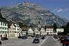 |
Old City, Medieval / Early Modern City | 723.950 | 211.300 | 47°02′28″N 9°04′11″E / 47.04114°N 9.069706°E | |
| 2701 | 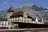 |
Glarus railway station building, goods shed, locomotive shed and turntable | Bahnhofplatz | 724.086 | 211.166 | 47°02′24″N 9°04′17″E / 47.039909°N 9.071459°E |
| 2690, 8804, 9331 |  |
Former High School, Cantonal Library and Cantonal Archive | Hauptstrasse 60 | 723.752 | 211.331 | 47°02′29″N 9°04′02″E / 47.041456°N 9.06711°E |
| 2691 | 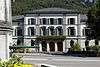 |
Courthouse with Side Pavillons | Spielhof 6 | 723.734 | 211.397 | 47°02′31″N 9°04′01″E / 47.042053°N 9.066891°E |
| 2692 |  |
Brunner House | Im Sand 9 | 723.766 | 211.085 | 47°02′21″N 9°04′02″E / 47.039241°N 9.067227°E |
| 2693 |  |
House in der Wiese | Wiesli 5 | 723.447 | 211.405 | 47°02′32″N 9°03′47″E / 47.042178°N 9.063118°E |
| 2694 | Schuler-Ganzoni House with Parking Structure | Gerichtshausstrasse 58 | 723.507 | 211.250 | 47°02′27″N 9°03′50″E / 47.040773°N 9.063865°E | |
| 2724 |  |
Cantonal Armory (Zeughaus) | Landstrasse 38 | 723.414 | 211.630 | 47°02′39″N 9°03′46″E / 47.044208°N 9.062745°E |
| 2696 |  |
Art Museum | Volksgarten | 724.086 | 211.023 | 47°02′19″N 9°04′17″E / 47.038623°N 9.07142°E |
| 2698 | 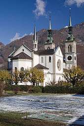 |
Swiss Reformed City Church with Reformed and Catholic Rectory |
Sandstrasse | 723.625 | 211.192 | 47°02′25″N 9°03′55″E / 47.040229°N 9.065402°E |
| 2676 | Factory Complex Jenny & Co. with Comptoir | Ennenda, Fabrikstrasse 7, 9 | 724.370 | 210.878 | 47°02′14″N 9°04′30″E / 47.037266°N 9.075116°E | |
| 9301 | G.T. Mandl-Foundation Library | Netstal, Kreuzbühlstrasse 68 | 723.045 | 213.866 | 47°03′52″N 9°03′31″E / 47.064385°N 9.058498°E | |
| 2786 | Powerplant am Löntsch | Netstal | 722.350 | 212.980 | 47°03′24″N 9°02′57″E / 47.056546°N 9.049112°E | |
| 2791 | Stähli House | Netstal, Grünhag 30 | 722.346 | 213.200 | 47°03′31″N 9°02′57″E / 47.058525°N 9.049118°E | |
| Unknown | ISOS Stadt: Glarus | |||||
| Unknown | ISOS Urbanized Village: Ennenda |
Glarus Nord
| KGS No.? |
Picture | Name | Street Address | CH1903 X coordinate | CH1903 Y coordinate | Location |
|---|---|---|---|---|---|---|
| 2650 | 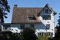 |
Herrensitz Milt (Elsener House) | Bilten, Elsenerstrasse 12 | 720.170 | 222.810 | 47°08′43″N 9°01′23″E / 47.145347°N 9.023037°E |
| 2689 |  |
Vor dem Wald (Roman Watchtower) |
Filzbach | 727.460 | 220.300 | 47°07′17″N 9°07′06″E / 47.121411°N 9.118416°E |
| 2751 |  |
Herrensitz Haltli | Mollis, Kerenzerstrasse 19 | 724.227 | 217.694 | 47°05′55″N 9°04′30″E / 47.09859°N 9.075105°E |
| Unknown | Hof and Höfli with Gartenpavillon | Mollis, Steinackerstrasse 4 | 724.263 | 216.692 | 47°05′22″N 9°04′31″E / 47.089572°N 9.075304°E | |
| 2752 |  |
Zwicky House | Mollis, Vorderdorfstrasse 59 | 724.201 | 216.726 | 47°05′24″N 9°04′28″E / 47.089889°N 9.074497°E |
| 2764 | Hammerschmiede | Mühlehorn, Kohlplatz | 731.529 | 219.761 | 47°06′57″N 9°10′19″E / 47.115768°N 9.171868°E | |
| 2767, 8511 |  |
Freuler Palace and Museum of Glarus | Näfels, Bahnhofstrasse 2 | 723.343 | 217.750 | 47°05′57″N 9°03′49″E / 47.099258°N 9.063479°E |
| 2768 |  |
Catholic Church St. Hilarius | Näfels | 723.380 | 217.890 | 47°06′02″N 9°03′50″E / 47.100511°N 9.064004°E |
| 2769 |  |
Letzi (Medieval Fortifications) | Näfels | 723.480 | 217.980 | 47°06′05″N 9°03′55″E / 47.101301°N 9.065346°E |
| 2797 | Industrial Plant and Settlement for Jenny & Co. | Niederurnen, Ziegelbrücke | 723.165 | 221.512 | 47°07′59″N 9°03′44″E / 47.133123°N 9.06216°E | |
| Unknown | ISOS Village: Mollis | |||||
| Unknown | ISOS Urbanized Village: Näfels | |||||
| Unknown |  |
ISOS Special Case: Factory Site, Ziegelbrücke |
Glarus Süd
| KGS No.? |
Picture | Name | Street Address | CH1903 X coordinate | CH1903 Y coordinate | Location |
|---|---|---|---|---|---|---|
| 9608 | Bergeten, Ruins of a Medieval Alpine Camp |
Braunwald | 716.500 | 200.190 | 46°56′33″N 8°58′08″E / 46.942574°N 8.968846°E | |
| 2654 |  |
Ortstockhaus | Braunwald, Braunwaldalp Unterstafel | 717.083 | 200.820 | 46°56′53″N 8°58′36″E / 46.948137°N 8.976663°E |
| 2661 | 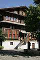 |
Gross House | Elm, Dorfstrasse | 732.050 | 197.937 | 46°55′10″N 9°10′21″E / 46.919403°N 9.172376°E |
| 2669 |  |
Suworow House | Elm, Dorf | 732.073 | 197.993 | 46°55′12″N 9°10′22″E / 46.919902°N 9.172695°E |
| 2662 |  |
Zentner House | Elm, Dorfstrasse | 732.009 | 197.897 | 46°55′09″N 9°10′19″E / 46.919052°N 9.171827°E |
| 8597 |  |
Naturwissenschaftliche Sammlungen Des Kantons Glarus, Engi |
Engi, Bergen | 730.340 | 205.288 | 46°59′09″N 9°09′07″E / 46.985849°N 9.15204°E |
| 2725 | Spinnerei Daniel Jenny & Co | Haslen | 723.350 | 205.000 | 46°59′05″N 9°03′36″E / 46.984595°N 9.0601°E | |
| 2729 |  |
Pantenbrücke (Bridge) | Linthal | 717.650 | 192.020 | 46°52′08″N 8°58′55″E / 46.868894°N 8.981836°E |
| 2655 | Sunnezyt House | Luchsingen, Hauptstrasse 18 | 721.048 | 201.010 | 46°56′57″N 9°01′44″E / 46.949135°N 9.028785°E | |
| 2740 |  |
Brummbach House | Matt, Brummbach 36 | 731.791 | 201.823 | 46°57′16″N 9°10′12″E / 46.954402°N 9.170103°E |
| 11741 | 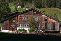 |
Steggut House | Matt, Brummbach 21 | 731.757 | 201.747 | 46°57′13″N 9°10′11″E / 46.953725°N 9.169634°E |
| 2742 |  |
Schiffmeister House (Schönenberger House) |
Mitlödi, Rain 3 | 724.657 | 207.877 | 47°00′37″N 9°04′41″E / 47.010224°N 9.078066°E |
| 8598 | Industrial Archives of Glarus | Schwanden, Mühlestrasse 19 / Iii | 724.691 | 206.089 | 46°59′39″N 9°04′41″E / 46.994138°N 9.078022°E | |
| Unknown | ISOS Dorf: Elm | |||||
| Unknown | ISOS Weiler: Steinibach | |||||
| Unknown | ISOS Dorf: Diesbach | |||||
| Unknown | ISOS Weiler: Adlenbach | |||||
| Unknown | ISOS Dorf: Rüti |
References
- All entries, addresses and coordinates are from: "Kantonsliste A-Objekte". KGS Inventar (in German). Federal Office of Civil Protection. 2009. Retrieved 25 April 2011.
External links
- Swiss Inventory of Cultural Property of National and Regional Significance, 2009 edition:
- "Revision of the PCP Inventory (Revision des KGS-Inventars)". KGS Forum. Federal Office of Civil Protection (13/2008). 2008.
This article is issued from Wikipedia - version of the 8/12/2016. The text is available under the Creative Commons Attribution/Share Alike but additional terms may apply for the media files.