List of cultural property of national significance in Switzerland: Neuchâtel
This list contains all cultural property of national significance (class A) in the canton of Neuchâtel from the 2009 Swiss Inventory of Cultural Property of National and Regional Significance. It is sorted by municipality and contains 90 individual buildings, 17 collections and 23 archaeological finds.
The geographic coordinates provided are in the Swiss coordinate system as given in the Inventory.
Bevaix
| KGS No.? |
Picture | Name | Street Address | CH1903 X coordinate | CH1903 Y coordinate | Location |
|---|---|---|---|---|---|---|
| 9626 |  |
Baie De Bevaix, Prehistoric Lake Shore Settlement | 553.000 | 197.000 | 46°55′21″N 6°49′18″E / 46.922434°N 6.821565°E | |
| 9627 | Treytel-A Sugiez, Neolithic Funerary and Cultural Center | 551.800 | 197.000 | 46°55′20″N 6°48′21″E / 46.922348°N 6.80581°E |
Boudry
| KGS No.? |
Picture | Name | Street Address | CH1903 X coordinate | CH1903 Y coordinate | Location |
|---|---|---|---|---|---|---|
| 3939 |  |
La Baume Du Four, Prehistoric Settlement | 552.350 | 201.325 | 46°57′41″N 6°48′45″E / 46.96129°N 6.812578°E | |
| Unknown | ISOS petite City / bourg: Boudry | |||||
| Unknown | ISOS cas particulier: Areuse Boudry | |||||
| Unknown | ISOS cas particulier: Grandchamp | |||||
| Unknown | ISOS cas particulier: Trois Rods |
Corcelles-Cormondrèche
| KGS No.? |
Picture | Name | Street Address | CH1903 X coordinate | CH1903 Y coordinate | Location |
|---|---|---|---|---|---|---|
| Unknown | ISOS village urbanisé: Corcelles |
Cornaux
| KGS No.? |
Picture | Name | Street Address | CH1903 X coordinate | CH1903 Y coordinate | Location |
|---|---|---|---|---|---|---|
| 9632 |  |
Ensemble De La Vieille Collection of Neolithic and Roman Sites |
569.000 | 209.000 | 47°01′53″N 7°01′51″E / 47.031313°N 7.030809°E | |
| 10462 | Gardens of the Souaillon Castle | Souaillon | 567.085 | 208.259 | 47°01′28″N 7°00′20″E / 47.024555°N 7.00567°E |
Cortaillod
| KGS No.? |
Picture | Name | Street Address | CH1903 X coordinate | CH1903 Y coordinate | Location |
|---|---|---|---|---|---|---|
| 4002 |  |
La Fabrique Neuve | Rue De La Fabrique 2 | 555.806 | 199.516 | 46°56′43″N 6°51′29″E / 46.945257°N 6.85816°E |
| 9629 | 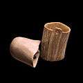 |
Le Petit Cortaillod, Prehistoric Lake Shore Settlement | 555.100 | 198.800 | 46°56′20″N 6°50′56″E / 46.93877°N 6.848957°E | |
| Unknown | ISOS village: Cortaillod |
Cressier
| KGS No.? |
Picture | Name | Street Address | CH1903 X coordinate | CH1903 Y coordinate | Location |
|---|---|---|---|---|---|---|
| 4009 |  |
Former Church of St-Martin and Jeanjaquet Castle | Route De Frochaux 27 | 568.649 | 210.927 | 47°02′55″N 7°01′34″E / 47.04863°N 7.026058°E |
| 9631 | |
Ensemble de la Vieille Thielle Collection of Neolithic and Roman Sites |
570.200 | 210.700 | 47°02′48″N 7°02′47″E / 47.046659°N 7.046484°E | |
| Unknown | ISOS village: Cressier (NE) |
Gorgier
| KGS No.? |
Picture | Name | Street Address | CH1903 X coordinate | CH1903 Y coordinate | Location |
|---|---|---|---|---|---|---|
| 4020 |  |
Gorgier Castle | Rue Du Château 27 | 550.268 | 195.452 | 46°54′30″N 6°47′09″E / 46.908311°N 6.785866°E |
| 9641 |  |
La Béroche, Gallo-Roman settlement |
549.200 | 194.900 | 46°54′12″N 6°46′19″E / 46.903265°N 6.77191°E | |
| 11790 |  |
Prehistoric Lake Shore Settlement | 550.900 | 194.900 | 46°54′12″N 6°47′39″E / 46.903392°N 6.794221°E |
Hauterive
| KGS No.? |
Picture | Name | Street Address | CH1903 X coordinate | CH1903 Y coordinate | Location |
|---|---|---|---|---|---|---|
| 11608 |  |
Laténium Cantonal Museum of Archeology |
Espace Paul Vouga | 564.441 | 206.350 | 47°00′26″N 6°58′16″E / 47.007248°N 6.971041°E |
La Brévine
| KGS No.? |
Picture | Name | Street Address | CH1903 X coordinate | CH1903 Y coordinate | Location |
|---|---|---|---|---|---|---|
| 3946 | 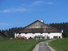 |
Double House | La Grosse Maison | 532.457 | 202.103 | 46°58′00″N 6°33′04″E / 46.966563°N 6.551113°E |
La Chaux-de-Fonds
| KGS No.? |
Picture | Name | Street Address | CH1903 X coordinate | CH1903 Y coordinate | Location |
|---|---|---|---|---|---|---|
| 3957 |  |
Abattoirs | Rue Du Commerce 120–126 | 552.639 | 215.782 | 47°05′29″N 6°48′54″E / 47.091349°N 6.814865°E |
| 3951 |  |
Ancien Manège (habitation collective ouvrière depuis 1968) |
Rue du Manège 17, 19 | 553.973 | 216.791 | 47°06′02″N 6°49′56″E / 47.100518°N 6.832332°E |
| 8845, 9338 |  |
Library of the City of Chaux-de-Fonds and the Département audiovisuel (DAV) | Rue du Progrès 33 | 553.516 | 217.217 | 47°06′16″N 6°49′35″E / 47.104318°N 6.826268°E |
| 3960 | 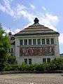 |
Crematorium | Rue de la Charrière 106 | 554.635 | 218.240 | 47°06′49″N 6°50′27″E / 47.113597°N 6.840906°E |
| 9804 |  |
Domaine des Arbres | Rue Moïse-Perret-Gentil 37 | 553.978 | 218.098 | 47°06′44″N 6°49′56″E / 47.112275°N 6.832265°E |
| 3978 | 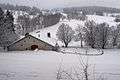 |
Farm House des Brandt | Les Petites-Corsettes 6 | 555.128 | 217.364 | 47°06′21″N 6°50′51″E / 47.105752°N 6.847489°E |
| 9803 |  |
Farm House Haute Fie, House Carrée | Le Valanvron 9 | 557.162 | 221.094 | 47°08′22″N 6°52′26″E / 47.139436°N 6.873931°E |
| 9802 | 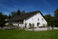 |
Farm House les Crêtets | Rue des Crêtets 148 | 552.508 | 215.572 | 47°05′22″N 6°48′47″E / 47.08945°N 6.813162°E |
| 3965 |  |
Grand Fountain | Avenue Léopold-Robert | 553.838 | 217.064 | 47°06′11″N 6°49′50″E / 47.102964°N 6.830526°E |
| 9793 |  |
Loge l‘Amitié | Rue de la Loge 8 | 553.851 | 216.857 | 47°06′04″N 6°49′51″E / 47.101103°N 6.830718°E |
| 9795 | 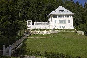 |
Blanche House | Chemin de Pouillerel 12 | 552.713 | 217.435 | 47°06′22″N 6°48′56″E / 47.106222°N 6.815667°E |
| 3974, 8670 |  |
Museum des Beaux-Arts | Rue des Musées 33 | 553.754 | 216.783 | 47°06′02″N 6°49′46″E / 47.100431°N 6.829448°E |
| 8766 |  |
Museum D‘Histoire Naturelle | Avenue Léopold-Robert 63 | 553.428 | 216.708 | 47°05′59″N 6°49′31″E / 47.099734°N 6.825161°E |
| 8671 | 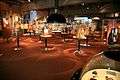 |
Museum international d’horlogerie «l’homme and le temps» | Rue des Musées 29 | 553.867 | 216.770 | 47°06′01″N 6°49′51″E / 47.100322°N 6.830938°E |
| 10113 |  |
Spillmann SA | Rue du Doubs 32 | 553.604 | 217.493 | 47°06′25″N 6°49′39″E / 47.106807°N 6.827399°E |
| 3980 |  |
Synagogue | Rue du Parc 63 | 553.358 | 216.810 | 47°06′02″N 6°49′27″E / 47.100646°N 6.824229°E |
| 3955 |  |
Théâtre and Salle de musique | Avenue Léopold-Robert 27–29 | 553.688 | 216.930 | 47°06′06″N 6°49′43″E / 47.101749°N 6.828563°E |
| 11623 | 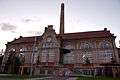 |
Power plant | Rue Numa-Droz 174 | 552.571 | 216.305 | 47°05′46″N 6°48′50″E / 47.096048°N 6.813915°E |
| 3956 |  |
Villa Anatole Schwob | Rue du Doubs 167 | 552.812 | 216.704 | 47°05′59″N 6°49′01″E / 47.099654°N 6.817048°E |
| 3961 |  |
Villa Fallet | Chemin de Pouillerel 1 | 552.789 | 217.302 | 47°06′18″N 6°49′00″E / 47.105031°N 6.816682°E |
| 3982 | .JPG) |
Villa Gallet | Rue David-Pierre-Bourquin 55 | 553.620 | 216.390 | 47°05′49″N 6°49′40″E / 47.096887°N 6.827723°E |
| 9794 |  |
Villa Jaquemet | Chemin de Pouillerel 8 | 552.710 | 217.306 | 47°06′18″N 6°48′56″E / 47.105062°N 6.815641°E |
| 9799 |  |
Villa Stotzer | Chemin de Pouillerel 6 | 552.670 | 217.251 | 47°06′16″N 6°48′54″E / 47.104564°N 6.81512°E |
| Unknown | UNESCO World Heritage Site: La Chaux-de-Fonds/Le Locle, Watchmaking Town Planning (since 2009) |
|||||
| Unknown | ISOS ville: La Chaux-de-Fonds |
La Chaux-du-Milieu
| KGS No.? |
Picture | Name | Street Address | CH1903 X coordinate | CH1903 Y coordinate | Location |
|---|---|---|---|---|---|---|
| 3983 |  |
Farm House Du Grand Cachot | Le Cachot 28 | 541.639 | 205.962 | 47°00′08″N 6°40′17″E / 47.002144°N 6.671262°E |
La Sagne
| KGS No.? |
Picture | Name | Street Address | CH1903 X coordinate | CH1903 Y coordinate | Location |
|---|---|---|---|---|---|---|
| 9800 |  |
Double House | Les Coeudres 39 | 550.847 | 209.195 | 47°01′55″N 6°47′31″E / 47.03197°N 6.79198°E |
| 4121 |  |
Temple | 552.781 | 211.382 | 47°03′06″N 6°49′02″E / 47.051782°N 6.817194°E | |
| Unknown | ISOS village: La Sagne |
La Tène
| KGS No.? |
Picture | Name | Street Address | CH1903 X coordinate | CH1903 Y coordinate | Location |
|---|---|---|---|---|---|---|
| 4051 | Clinique De Préfargier, Maison De Santé | Marin-Epagnier, Préfargier 6 | 567.309 | 206.223 | 47°00′23″N 7°00′32″E / 47.006253°N 7.008763°E | |
| 9634 | Les Bourguignonnes-les-Perveuils, zones cultuelles | Marin-Epagnier | 567.700 | 207.000 | 47°00′48″N 7°00′50″E / 47.013261°N 7.013849°E | |
| 4049 |  |
La Tène, La Tène culture Settlement |
568.300 | 206.100 | 47°00′19″N 7°01′18″E / 47.005194°N 7.021802°E | |
| 9633 | Les marais d‘Epagnier, Prehistoric and Medieval Sites |
568.700 | 206.800 | 47°00′41″N 7°01′37″E / 47.01151°N 7.027014°E | ||
| Unknown | ISOS cas particulier: Cité Martini | |||||
| Unknown | ISOS cas particulier: Montmirail | |||||
| Unknown | ISOS cas particulier: Préfargier |
Le Landeron
| KGS No.? |
Picture | Name | Street Address | CH1903 X coordinate | CH1903 Y coordinate | Location |
|---|---|---|---|---|---|---|
| 4026 |  |
Chapelle Ste-Anne | 570.418 | 212.029 | 47°03′31″N 7°02′57″E / 47.058623°N 7.049266°E | |
| 9796 |  |
Croix du Bourg | Centre Bourg | 571.574 | 211.134 | 47°03′02″N 7°03′52″E / 47.050623°N 7.064537°E |
| 9630 | |
Ensemble de la Vieille Thielle, Collection of Neolithic and Roman Era Sites |
571.400 | 210.600 | 47°02′45″N 7°03′44″E / 47.045813°N 7.062281°E | |
| 4028 |  |
Fountain de St-Maurice | Bourg sud | 571.588 | 211.082 | 47°03′01″N 7°03′53″E / 47.050156°N 7.064725°E |
| 9487 |  |
Fountain du Vaillant | Bourg nord | 571.570 | 211.177 | 47°03′04″N 7°03′52″E / 47.05101°N 7.064482°E |
| 4025, 8731 |  |
Town Hall with the Dix-Mille-Martyrs Chapel and Museum | Ville 35 | 571.613 | 211.083 | 47°03′01″N 7°03′54″E / 47.050166°N 7.065054°E |
| Unknown | ISOS petite City / bourg: Le Landeron |
Le Locle
| KGS No.? |
Picture | Name | Street Address | CH1903 X coordinate | CH1903 Y coordinate | Location |
|---|---|---|---|---|---|---|
| 10493 |  |
Ancien Hôtel des Postes | Rue Marie-Anne-Calame 5 | 547.762 | 212.247 | 47°03′33″N 6°45′04″E / 47.059186°N 6.751044°E |
| 4035, 8674 |  |
Monts Castle and Museum d’horlogerie | Route des | 547.681 | 212.745 | 47°03′49″N 6°45′00″E / 47.063659°N 6.74992°E |
| 4043 | 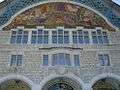 |
Town hall | Avenue de l‘Hôtel-de-Ville 1 | 547.365 | 211.869 | 47°03′21″N 6°44′45″E / 47.055755°N 6.745862°E |
| 11624 |  |
Immeuble | Rue du Crêt-Vaillant 28 | 547.735 | 212.312 | 47°03′35″N 6°45′02″E / 47.059769°N 6.750681°E |
| 4037, 8673 |  |
Moulins souterrains du Col-des-Roches (Cave mills in the Col des Roches) |
Col-des-Roches 25 | 545.493 | 211.137 | 47°02′56″N 6°43′17″E / 47.049019°N 6.721312°E |
| 4047 |  |
Villa Favre-Jacot | La Côte-des-Billodes 6 | 546.480 | 211.716 | 47°03′16″N 6°44′03″E / 47.054308°N 6.734233°E |
| 10114 |  |
Zenith SA | Rue des Billodes 30–38/ Rue de la Côte 37, 39, 41 | 546.955 | 211.813 | 47°03′19″N 6°44′26″E / 47.055218°N 6.740473°E |
| Unknown | UNESCO World Heritage Site: La Chaux-de-Fonds/Le Locle, Watchmaking Town Planning (since 2009) |
|||||
| Unknown | ISOS ville: Le Locle |
Les Brenets
| KGS No.? |
Picture | Name | Street Address | CH1903 X coordinate | CH1903 Y coordinate | Location |
|---|---|---|---|---|---|---|
| Unknown | ISOS village urbanisé: Les Brenets |
Les Verrières
| KGS No.? |
Picture | Name | Street Address | CH1903 X coordinate | CH1903 Y coordinate | Location |
|---|---|---|---|---|---|---|
| Unknown | ISOS village: Les Verrières |
Milvignes
| KGS No.? |
Picture | Name | Street Address | CH1903 X coordinate | CH1903 Y coordinate | Location |
|---|---|---|---|---|---|---|
| 9624 | 20110831_1777_HDR.jpg) |
Baie D‘Auvernier, Prehistoric Lake Shore Settlement | 557.100 | 202.600 | 46°58′23″N 6°52′30″E / 46.973083°N 6.874864°E | |
| 3929 | 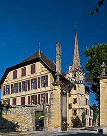 |
Auvernier Castle | Place des Epancheurs 4, 6 | 557.250 | 202.784 | 46°58′29″N 6°52′37″E / 46.974747°N 6.876818°E |
| 9091 |  |
Arsenal | Route De L‘Arsenal 2 | 556.145 | 201.800 | 46°57′57″N 6°51′45″E / 46.965824°N 6.862392°E |
| 9625 | 20110831_1772_HDR.jpg) |
Baie d‘Auvernier, Prehistoric Lake Shore Settlement | 556.800 | 202.250 | 46°58′12″N 6°52′15″E / 46.969915°N 6.870955°E | |
| 3986, 8672 |  |
Colombier Castle and Museum militaire et des toiles peintes Villa romaine, fortifications / château médiéval |
556.203 | 201.846 | 46°57′58″N 6°51′47″E / 46.966242°N 6.86315°E | |
| 3988 |  |
Domaine de Vaudijon | Chemin de Notre-Dame 30 | 555.894 | 201.182 | 46°57′37″N 6°51′33″E / 46.960249°N 6.859154°E |
| 3987 |  |
House de maître du Bied | Allée du Bied 48 | 556.940 | 200.904 | 46°57′28″N 6°52′23″E / 46.957817°N 6.872923°E |
| 3989 |  |
Manoir Le Pontet | Chemin du Pontet 2 | 556.094 | 201.999 | 46°58′03″N 6°51′42″E / 46.967611°N 6.861703°E |
| Unknown | ISOS village: Auvernier | |||||
| Unknown | ISOS village urbanisé: Colombier | |||||
| Unknown | ISOS cas particulier: Areuse (Boudry |
Neuchâtel
| KGS No.? |
Picture | Name | Street Address | CH1903 X coordinate | CH1903 Y coordinate | Location |
|---|---|---|---|---|---|---|
| 9798 | 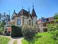 |
Abbey De Fontaine-André | Chemin De L‘Abbaye 51 | 563.334 | 206.687 | 47°00′37″N 6°57′23″E / 47.010219°N 6.956457°E |
| 9340 |  |
Pasteur Library of Neuchâtel | 561.733 | 204.986 | 46°59′41″N 6°56′08″E / 46.994828°N 6.935547°E | |
| 4059, 8783 |  |
Neuchâtel Castle and Archives de l‘Etat de Neuchâtel | Rue de la Collégiale 12 | 561.060 | 204.691 | 46°59′32″N 6°55′36″E / 46.992135°N 6.926724°E |
| 4071, 9339, 8964 | 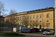 |
Collège Latin, Library publique and universitaire de Neuchâtel, | Place Numa-Droz 3 | 561.398 | 204.472 | 46°59′25″N 6°55′52″E / 46.990185°N 6.931186°E |
| 4060 |  |
Collegiate Church of Neuchâtel and cénotaphe | Rue de la Collégiale 5 | 561.023 | 204.671 | 46°59′31″N 6°55′34″E / 46.991953°N 6.92624°E |
| 4075 | 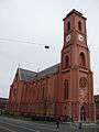 |
Notre-Dame Church | Rue Ed.-Desor 1 | 562.185 | 204.959 | 46°59′41″N 6°56′29″E / 46.994611°N 6.941491°E |
| 4081 | 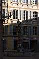 |
Fountain de la Justice | Rue de l‘Hôpital | 561.245 | 204.663 | 46°59′31″N 6°55′45″E / 46.991894°N 6.929159°E |
| 4080 |  |
Fountain de la place de l‘Hôtel de Ville | 561.413 | 204.666 | 46°59′31″N 6°55′53″E / 46.991931°N 6.931367°E | |
| 4084 |  |
Fountain de la rue des Moulins | Passage des Boucheries | 561.185 | 204.708 | 46°59′32″N 6°55′42″E / 46.992295°N 6.928366°E |
| 4078 |  |
Fountain de la rue du Château | Rue du Château | 561.025 | 204.613 | 46°59′29″N 6°55′35″E / 46.991432°N 6.926271°E |
| 4077 | 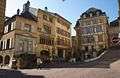 |
Fountain du Banneret | Rue Fleury | 561.186 | 204.634 | 46°59′30″N 6°55′42″E / 46.99163°N 6.928385°E |
| 4079 | 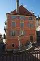 |
Fountain du Griffon | Rue du Pommier | 561.116 | 204.636 | 46°59′30″N 6°55′39″E / 46.991644°N 6.927465°E |
| 4083 |  |
Fountain du Lion | Rue du Temple Neuf | 561.295 | 204.580 | 46°59′28″N 6°55′47″E / 46.99115°N 6.929823°E |
| 4082 |  |
Fountain du Neubourg | Fountain du Neubourg | 561.255 | 204.754 | 46°59′34″N 6°55′45″E / 46.992713°N 6.929282°E |
| 10116 | 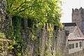 |
Fortifications | 561.200 | 204.650 | 46°59′30″N 6°55′43″E / 46.991775°N 6.928568°E | |
| 4064 |  |
Galeries de l‘Histoire | Avenue Du Peyrou 7 | 561.557 | 204.914 | 46°59′39″N 6°56′00″E / 46.99417°N 6.933239°E |
| 4088 |  |
Grande Rochette | Avenue de la Gare 24 | 561.618 | 205.071 | 46°59′44″N 6°56′02″E / 46.995586°N 6.934027°E |
| 4061 |  |
City Hall | Rue de l‘Hôtel-de-Ville 2 | 561.362 | 204.646 | 46°59′30″N 6°55′51″E / 46.991748°N 6.930698°E |
| 4062 | 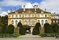 |
Hôtel Du Peyrou | Avenue Du Peyrou 1, 3 | 561.588 | 204.898 | 46°59′39″N 6°56′01″E / 46.994028°N 6.933648°E |
| 4063 | 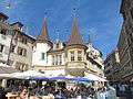 |
Maison Des Halles | Rue du Trésor 4 | 561.204 | 204.581 | 46°59′28″N 6°55′43″E / 46.991154°N 6.928627°E |
| 4092 |  |
House | Rue du Pommier 7 | 561.098 | 204.603 | 46°59′29″N 6°55′38″E / 46.991346°N 6.927231°E |
| 9500 |  |
House | Rue du Pommier 8 / Rue du Château 19 | 561.067 | 204.615 | 46°59′29″N 6°55′37″E / 46.991452°N 6.926823°E |
| 9501 |  |
House | Rue du Pommier 9 | 561.078 | 204.588 | 46°59′28″N 6°55′37″E / 46.99121°N 6.92697°E |
| 9637 | _2_110124.jpg) |
Monruz, Paleolithic open-air settlement |
563.670 | 205.900 | 47°00′11″N 6°57′39″E / 47.003158°N 6.960938°E | |
| 4065, 8702, 8968 |  |
Museum d‘art and d‘histoire de Neuchâtel | Esplanade Léopold-Robert 1 | 561.725 | 204.616 | 46°59′29″N 6°56′08″E / 46.991499°N 6.935473°E |
| 8675 |  |
Museum d‘ethnographie | Rue de Saint-Nicolas 2 | 560.654 | 204.497 | 46°59′25″N 6°55′17″E / 46.990366°N 6.921404°E |
| 8676 |  |
Muséum d‘histoire naturelle | Rue des Terreaux 14 | 561.364 | 204.782 | 46°59′35″N 6°55′51″E / 46.992971°N 6.930713°E |
| 4094 |  |
Observatoire cantonal | Rue de l‘Observatoire 52 | 563.058 | 205.559 | 47°00′00″N 6°57′11″E / 47.000057°N 6.952919°E |
| 4089 |  |
Parc de la Petite Rochette | Avenue de la Gare | 561.430 | 204.930 | 46°59′40″N 6°55′54″E / 46.994307°N 6.931568°E |
| 10118 | 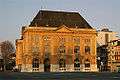 |
Poste | Place Numa-Droz 2 | 561.464 | 204.553 | 46°59′27″N 6°55′55″E / 46.990917°N 6.932047°E |
| 4108 |  |
Tour des prisons and former prison | 560.999 | 204.587 | 46°59′28″N 6°55′33″E / 46.991196°N 6.925931°E | |
| 4066 |  |
Villa James de Pury and a building with murals of Hans Erni | Rue de Saint-Nicolas 4 | 560.568 | 204.539 | 46°59′27″N 6°55′13″E / 46.990739°N 6.92027°E |
| Unknown | ISOS ville: Neuchâtel |
Rochefort
| KGS No.? |
Picture | Name | Street Address | CH1903 X coordinate | CH1903 Y coordinate | Location |
|---|---|---|---|---|---|---|
| 4119 | 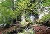 |
Cotencher, Paleolithic Cave | 551.585 | 201.600 | 46°57′49″N 6°48′09″E / 46.963709°N 6.802498°E |
Saint-Aubin-Sauges
| KGS No.? |
Picture | Name | Street Address | CH1903 X coordinate | CH1903 Y coordinate | Location |
|---|---|---|---|---|---|---|
| 9640 |  |
Le Béroche, Gallo-Romain Settlement |
548.900 | 194.700 | 46°54′05″N 6°46′05″E / 46.901443°N 6.767996°E | |
| 9639 |  |
Port Conty / Tivoli, Neolithic Settlement |
549.000 | 193.300 | 46°53′20″N 6°46′10″E / 46.888857°N 6.769465°E |
Saint-Blaise
| KGS No.? |
Picture | Name | Street Address | CH1903 X coordinate | CH1903 Y coordinate | Location |
|---|---|---|---|---|---|---|
| Unknown | ISOS village urbanisé: Saint-Blaise |
Valangin
| KGS No.? |
Picture | Name | Street Address | CH1903 X coordinate | CH1903 Y coordinate | Location |
|---|---|---|---|---|---|---|
| 4139 |  |
Valangin Castle | 559.558 | 207.197 | 47°00′53″N 6°54′24″E / 47.014587°N 6.906756°E | |
| 4142 |  |
Collégiale (temple) | Place de la Collégiale | 559.580 | 207.373 | 47°00′58″N 6°54′25″E / 47.016171°N 6.90703°E |
| Unknown | ISOS petite City / bourg: Valangin | |||||
| Unknown | ISOS cas particulier: Bussy / Le Sorgereux | |||||
| Unknown | ISOS cas particulier: La Borcarderie |
Val-de-Ruz
| KGS No.? |
Picture | Name | Street Address | CH1903 X coordinate | CH1903 Y coordinate | Location |
|---|---|---|---|---|---|---|
| 3985 | Farm House | Rue Jean-Labran 4 | 560.701 | 212.814 | 47°03′55″N 6°55′17″E / 47.065179°N 6.921301°E | |
| 10109 | Farm House | Rue Jean-Labran 6 | 560.648 | 212.814 | 47°03′55″N 6°55′14″E / 47.065176°N 6.920603°E | |
| 10110 | Farm House Aux Planches | Les Planches 52, 56 | 563.912 | 215.104 | 47°05′09″N 6°57′48″E / 47.08596°N 6.963387°E | |
| 4014 |  |
Engollon Church | Village | 560.692 | 209.801 | 47°02′17″N 6°55′17″E / 47.038077°N 6.921444°E |
| 4013 |  |
La Bonneville Abandoned Village |
560.250 | 209.400 | 47°02′04″N 6°54′56″E / 47.034444°N 6.915664°E | |
| 4017 |  |
Moulin de Bayerel | Route de Bayerel | 561.332 | 210.031 | 47°02′25″N 6°55′47″E / 47.040184°N 6.929845°E |
| Unknown | ISOS village: Dombresson |
Val-de-Travers
| KGS No.? |
Picture | Name | Street Address | CH1903 X coordinate | CH1903 Y coordinate | Location |
|---|---|---|---|---|---|---|
| 10108 | |
Farm House no. 1201, Monlési | Boveresse | 535.450 | 197.726 | 46°55′39″N 6°35′28″E / 46.927491°N 6.59106°E |
| 9791 |  |
House des Chats, House Petitpierre | Boveresse | 536.073 | 196.480 | 46°54′59″N 6°35′58″E / 46.916344°N 6.599414°E |
| 9792 |  |
Séchoir à absinthe | Boveresse, Route de Môtiers | 536.250 | 196.545 | 46°55′01″N 6°36′06″E / 46.916945°N 6.601729°E |
| 4054 | 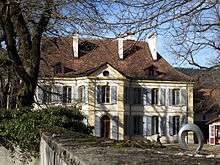 |
Ivernois Castle, Maison Boy de la Tour | Môtiers, Grande Rue 7 | 537.016 | 195.816 | 46°54′38″N 6°36′43″E / 46.910461°N 6.611885°E |
| 4052 |  |
Hôtel des Six-Communes | Môtiers, Rue Centrale 1 | 536.962 | 195.905 | 46°54′41″N 6°36′40″E / 46.911257°N 6.611164°E |
| 4055, 9638 | 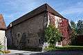 |
Prieuré / Prieuré St-Pierre High Middle Ages Church |
Môtiers, Rue Centrale 7 | 537.030 | 195.942 | 46°54′42″N 6°36′43″E / 46.911596°N 6.612051°E |
| 4056 | 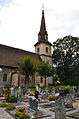 |
Temple | Môtiers, Ruelle du Temple | 537.010 | 195.970 | 46°54′43″N 6°36′42″E / 46.911846°N 6.611785°E |
| 4136 | 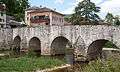 |
Areuse Bridge | Travers | 541.675 | 198.869 | 46°56′18″N 6°40′22″E / 46.938347°N 6.672645°E |
| Unknown | ISOS village: Buttes | |||||
| Unknown | ISOS village: Les Verrières | |||||
| Unknown | ISOS village: Môtiers | |||||
| Unknown | ISOS village urbanisé: Couvet | |||||
| Unknown | ISOS village urbanisé: Fleurier | |||||
| Unknown | ISOS village urbanisé: Travers |
Vaumarcus
| KGS No.? |
Picture | Name | Street Address | CH1903 X coordinate | CH1903 Y coordinate | Location |
|---|---|---|---|---|---|---|
| 9642 | La Redoute Des Bourguignons, Prehistoric Site / Hallstatt Tumulus |
547.000 | 192.450 | 46°52′52″N 6°44′36″E / 46.881055°N 6.743323°E |
References
- All entries, addresses and coordinates are from: "Kantonsliste A-Objekte". KGS Inventar (in German). Federal Office of Civil Protection. 2009. Retrieved 25 April 2011.
External links
- Swiss Inventory of Cultural Property of National and Regional Significance, 2009 edition:
- "Revision of the PCP Inventory (Revision des KGS-Inventars)". KGS Forum. Federal Office of Civil Protection (13/2008). 2008.
This article is issued from Wikipedia - version of the 11/6/2016. The text is available under the Creative Commons Attribution/Share Alike but additional terms may apply for the media files.