Glarus
| Glarus | ||
|---|---|---|
 | ||
| ||
 Glarus | ||
|
Location of Glarus  | ||
| Coordinates: 47°02′N 9°04′E / 47.033°N 9.067°ECoordinates: 47°02′N 9°04′E / 47.033°N 9.067°E | ||
| Country | Switzerland | |
| Canton | Glarus | |
| District | n.a. | |
| Area[1] | ||
| • Total | 103.7 km2 (40.0 sq mi) | |
| Elevation (Stadtkirche Glarus) | 472 m (1,549 ft) | |
| Population (Dec 2015[2]) | ||
| • Total | 12,570 | |
| • Density | 120/km2 (310/sq mi) | |
| Demonym(s) | German: Glarner(in) | |
| Postal code | 8750, 8754, 8755 | |
| SFOS number | 1632 | |
| Localities | Glarus, Netstal, Ennetbühls, Ennenda, Riedern, Hinter-Klöntal, Richisau, Klöntal | |
| Surrounded by | Glarus Nord, Glarus Süd, Muotathal (SZ), Innerthal (SZ) | |
| Twin towns | Wiesbaden-Biebrich (Germany) | |
| Website |
www SFSO statistics | |

Glarus (German: [ˈɡlaːrʊs]; French: Glaris; Italian: Glarona; Romansh: Glaruna) is the capital of the canton of Glarus in Switzerland. Since 1 January 2011, the municipality Glarus incorporates the former municipalities of Ennenda, Netstal and Riedern.[3]
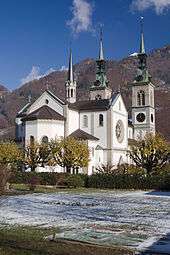
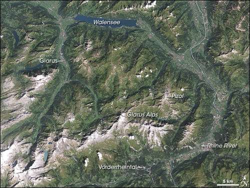
Glarus lies on the river Linth between the foot of the Glärnisch (part of the Schwyzer Alps) to the west and the Schilt (Glarus Alps)to the east. Very few buildings built before the fire of 1861 remain. Wood, textile, and plastics, as well as printing, are the dominant industries. The symbol of the city is the neo-romanesque city church.
The official language of Glarus is (the Swiss variety of Standard) German, but the main spoken language is the local Alemannic Swiss German dialect.
History

Glarus is first mentioned in the early 9th Century in Latin as Clarona. In 1178 it was first mentioned in German as Glarus.[4]
On 10 February 878, the Emperor Charles the Fat gave his wife Richgard or Richardis the monasteries of Säckingen, of St. Felix and of Regula in Zürich as a royal estate. This land grant included extensive political rights and a large estate. This estate covered land in the Rhine and Frick valleys, the southern Hotzenwald, land in Zürich, along Lake Walen and the valley of Glarus. Glarus remained under the Säckingen Abbey until 1395 (intermittently under the overlordship of either the Counts_of_Lenzburg and Kyburg and/or Raetia Curiensis[5]) , when the Glarus valley broke away from the Abbey and became independent.[6]
It became the capital of the Linth valley in 1419. In the 18th and 19th centuries, the valley began to be industrialized. Huldrych Zwingli a leader of the Reformation in Switzerland served in his first, Roman Catholic, ecclesiastical post in Glarus, starting around 1506. He served there for ten years. It was in Glarus, whose soldiers were used as mercenaries in Europe, that Zwingli became involved in politics. The Swiss Confederation was embroiled in various campaigns with its neighbours: the French, the Habsburgs, and the Papal States. Zwingli placed himself solidly on the side of the Holy See. In return, Pope Julius II honoured Zwingli by providing him with an annual pension. He took the role of chaplain in several campaigns in Italy, including the Battle of Novara in 1513. However, the decisive defeat of the Swiss in the Battle of Marignano caused a shift in mood in Glarus in favour of the French rather than the pope. Zwingli, the papal partisan, found himself in a difficult position and he decided to retreat to Einsiedeln in the canton of Schwyz. While he was not a reformer at Glarus, there he began to develop the ideas that would lead to the break with the Catholic Church in Zürich
In 1528 the Reformation gained a foothold in Glarus, directed by Zwingli in Zürich. Even though he had preached in Glarus for 10 years, the town remained strongly Catholic. However, following the Second war of Kappel in 1531 both the Catholic and Protestant residents were given the right to worship in town. This led to both religious groups using the town church simultaneously, an arrangement that caused numerous problems. By the 18th Century both the groups shared the church but had separate organs. In 1697 there were two financially and theologically independent parishes meeting in the city church.[7]
Following the French invasion in 1798, Glarus became the capital of the Canton of Linth in the Helvetic Republic. The administration of the Canton moved into Glarus. However, the new administrators had difficulties in establishing and enforcing any new regulations. In August 1802 the administrators of the new Canton left Glarus for Rapperswil due to the difficulties they had faced in Glarus. In 1803, with the Act of Mediation, the Canton of Linth was dissolved and Glarus became the capital of the smaller Canton of Glarus.[8]
In 1859, the railway reached Glarus from Weesen. The extension to Schwanden and Linthal opened in 1879.[9]
On the 10/11 May 1861, the town was devastated by a fire that was fanned by a violent Föhn or south wind, rushing down from the high mountains through the natural funnel formed by the Linth valley. The total loss is estimated at about half a million sterling, of which about £100,000 were made up by subscriptions that poured in from every side. About two-thirds of Glarus (593 buildings) were destroyed in the big fire. After this incident, Glarus was rebuilt in block fashion according to construction plans by Bernhard Simon and Johann Caspar Wolff.[10]
In 1864, the first European labor law to protect workers was introduced in Glarus, prohibiting workers from working more than 12 hours a day.
Geography

The town is located in the Glarner Mittelland on a broad valley floor between the Glärnisch and the Linth.
The municipality Glarus before 2011 had an area of 69.2 km2 (26.7 sq mi). Of this area, 23% was used for agricultural purposes, while 31.4% was forested; of the rest of the land, 2.7% was settled (buildings or roads) and the remainder (42.9%) was non-productive (2006 figures).[11]
With the incorporation of Ennenda, Netstal and Riedern in 2011, the municipality Glarus now has an area of 103.7 km2 (40.04 sq mi).[1] Based on the 2004/09 survey, about 26.3% of the total area is used for agricultural purposes, while 34.3% is forested. Of the rest of the land, 4.1% is settled (buildings or roads) and 35.2% is unproductive land. Over the past two decades (1979/85-2004/09) the amount of land that is settled has increased by 42 ha (100 acres) and the agricultural land has decreased by 60 ha (150 acres).[12]
Demographics
Glarus has a population (as of December 2015) of 12,570.[13] As of 2013, 24.9% of the population are resident foreign nationals. Over the last 3 years (2010-2013) the population has changed at a rate of 2.07%. The birth rate in the municipality, in 2013, was 9.8 while the death rate was 8.4 per thousand residents.[12]
As of 2013, children and teenagers (0–19 years old) make up 20.6% of the population, while adults (20–64 years old) are 61.1% and seniors (over 64 years old) make up 18.3%.[12]
Most of the population (as of 2000) speaks German (86.0%), with Italian being second most common (4.8%) and Albanian being third (2.6%).[11]
Historical population
The historical population is given in the following table:[4]
| year | population | Swiss Citizens | % German Speaking | % Protestant | % Roman Catholic |
|---|---|---|---|---|---|
| 1554 | ca. 1,550 | ||||
| 1682 | ca. 1,200 | ||||
| 1777 | ca. 2,400 | ||||
| 1837 | 4,094 | ||||
| 1850 | 4,082 | 3,960 | 86.0% | 14.0% | |
| 1870 | 5,485 | 5,204 | 77.7% | 22.6% | |
| 1888 | 5,357 | 4,968 | 98.1% | 71.6% | 28.0% |
| 1900 | 4,877 | 4,424 | 97.5% | 74.2% | 25.6% |
| 1910 | 5,123 | 4,471 | 94.8% | 70.8% | 28.7% |
| 1930 | 5,269 | 4,858 | 97.7% | 70.5% | 29.2% |
| 1950 | 5,724 | 5,376 | 96.2% | 68.0% | 31.4% |
| 1970 | 6,189 | 5,215 | 86.9% | 60.5% | 38.9% |
| 1990 | 5,728 | 4,723 | 86.1% | 51.9% | 42.4% |
| 2000 | 5,556 | 4,379 | 86.0% | 45.4% | 37.7% |
Economy
As of 2012, there were a total of 8,148 people employed in the municipality. Of these, a total of 175 people worked in 63 businesses in the primary economic sector. The secondary sector employed 2,479 workers in 200 separate businesses. Finally, the tertiary sector provided 5,494 jobs in 923 businesses. In 2013 a total of 2.% of the population received social assistance.[12]
Politics
In the 2015 federal election the most popular party was the BDP with 49.7% of the vote, followed by the SP with 47.7%. The remaining 2.6% went to unaffiliated or minor party candidates. In the federal election, a total of 3,250 votes were cast, and the voter turnout was 41.1%. The 2015 election saw a large change in the voting when compared to 2011. The percentage of the vote received by the SP increased sharply from 28.9% in 2011 to 47.7% in 2015, while the percentage that the BDP dropped from 57.7% to 49.7%.[14]
Crime
In 2014 the crime rate, of the over 200 crimes listed in the Swiss Criminal Code (running from murder, robbery and assault to accepting bribes and election fraud), in Glarus was 48.2 per thousand residents. This rate is only 74.6% of the average rate in the entire country. During the same period, the rate of drug crimes was 10.2 per thousand residents, which is similar to the rate in Glarus Süd, but about twice as high as the rate in Glarus Nord.[15]
Education
In Glarus about 71.3% of the population (between age 25-64) have completed either non-mandatory upper secondary education or additional higher education (either university or a Fachhochschule).[11]
Transport
Glarus railway station is on the Ziegelbrücke to Linthal railway line. It is served by the Zürich S-Bahn service S25 between Zürich and Linthal, and by the St. Gallen S-Bahn service S6 between Rapperswil and Schwanden. Both services operate once per hour, combining to provide two trains per hour between Ziegelbrücke and Schwanden. The stations of Ennenda and Netstal are also in the municipality, and served by the same trains.[16][17][18]
Climate
Between 1981 and 2010 Glarus had an average of 144.2 days of rain per year and on average received 1,506 mm (59.3 in) of precipitation. The wettest month was July during which time Glarus received an average of 198 mm (7.8 in) of precipitation. During this month there was precipitation for an average of 14.6 days. The months with the most days of precipitation were July and August. The driest month of the year was February with an average of 85 mm (3.3 in) of precipitation over 9.4 days.[19]
| Climate data for Glarus (517m a.s.l., reference period 1981–2010) | |||||||||||||
|---|---|---|---|---|---|---|---|---|---|---|---|---|---|
| Month | Jan | Feb | Mar | Apr | May | Jun | Jul | Aug | Sep | Oct | Nov | Dec | Year |
| Average high °C (°F) | 2.6 (36.7) |
4.1 (39.4) |
9.0 (48.2) |
13.9 (57) |
18.8 (65.8) |
21.3 (70.3) |
23.4 (74.1) |
22.5 (72.5) |
18.4 (65.1) |
14.0 (57.2) |
7.6 (45.7) |
3.7 (38.7) |
13.3 (55.9) |
| Daily mean °C (°F) | −0.7 (30.7) |
0.4 (32.7) |
4.5 (40.1) |
8.7 (47.7) |
13.2 (55.8) |
16.0 (60.8) |
18.0 (64.4) |
17.3 (63.1) |
13.8 (56.8) |
9.7 (49.5) |
4.0 (39.2) |
0.6 (33.1) |
8.8 (47.8) |
| Average low °C (°F) | −3.6 (25.5) |
−2.9 (26.8) |
0.5 (32.9) |
3.8 (38.8) |
8.1 (46.6) |
11.1 (52) |
13.2 (55.8) |
13.0 (55.4) |
9.8 (49.6) |
6.0 (42.8) |
1.0 (33.8) |
−2.2 (28) |
4.8 (40.6) |
| Average precipitation mm (inches) | 86 (3.39) |
85 (3.35) |
105 (4.13) |
97 (3.82) |
130 (5.12) |
168 (6.61) |
198 (7.8) |
190 (7.48) |
138 (5.43) |
96 (3.78) |
108 (4.25) |
104 (4.09) |
1,506 (59.29) |
| Average snowfall cm (inches) | 32.7 (12.87) |
29.9 (11.77) |
14.4 (5.67) |
0.5 (0.2) |
0 (0) |
0 (0) |
0 (0) |
0 (0) |
0 (0) |
0.7 (0.28) |
10.9 (4.29) |
31.5 (12.4) |
120.6 (47.48) |
| Average precipitation days (≥ 1.0 mm) | 10.6 | 9.4 | 12.3 | 11.9 | 13.8 | 14.2 | 14.6 | 14.6 | 11.7 | 9.7 | 10.9 | 10.5 | 144.2 |
| Average snowy days (≥ 1.0 cm) | 5.7 | 4.9 | 3.7 | 0.3 | 0 | 0 | 0 | 0 | 0 | 0.1 | 1.8 | 5.1 | 21.6 |
| Average relative humidity (%) | 82 | 78 | 73 | 68 | 71 | 74 | 75 | 78 | 81 | 81 | 82 | 83 | 77 |
| Mean monthly sunshine hours | 61 | 68 | 88 | 124 | 152 | 153 | 171 | 155 | 106 | 86 | 59 | 51 | 1,274 |
| Percent possible sunshine | 43 | 46 | 46 | 44 | 44 | 44 | 48 | 48 | 51 | 50 | 41 | 37 | 46 |
| Source: MeteoSwiss[19] | |||||||||||||
Gallery
 Town center of Glarus
 Kantonsparlement
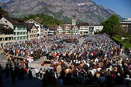
 Landsgemeindeplatz
 Glärnisch
 Glarus railway station
International relations
Twin towns — Sister cities
Glarus is twinned with:
Map
References
- 1 2 Arealstatistik Standard - Gemeindedaten nach 4 Hauptbereichen
- ↑ Swiss Federal Statistical Office - STAT-TAB, online database – Ständige und nichtständige Wohnbevölkerung nach institutionellen Gliederungen, Geburtsort und Staatsangehörigkeit (German) accessed 30 August 2016
- ↑ Amtliches Gemeindeverzeichnis der Schweiz published by the Swiss Federal Statistical Office (German) accessed 18 February 2011
- 1 2 Glarus in German, French and Italian in the online Historical Dictionary of Switzerland.
- ↑ Lothar Deplazes: Raetia Curiensis in German, French and Italian in the online Historical Dictionary of Switzerland.
- ↑ Säckingen in German, French and Italian in the online Historical Dictionary of Switzerland.
- ↑ Glarus from the High Middle Ages until the 18th Century-Churches in German, French and Italian in the online Historical Dictionary of Switzerland.
- ↑ Glarus in the 19. and 20. Centuries-Political and administrative development in German, French and Italian in the online Historical Dictionary of Switzerland.
- ↑ "Güterschuppen 8750 Glarus" (in German). Schweizer Heimatschutz.ch. Retrieved 2013-05-22.
- ↑
 Chisholm, Hugh, ed. (1911). "Glarus (capital)". Encyclopædia Britannica (11th ed.). Cambridge University Press.
 - 1 2 3 Swiss Federal Statistical Office accessed 10-Sep-2009
- 1 2 3 4 Swiss Federal Statistical Office - Regional portraits accessed 2 May 2016
- ↑ Swiss Federal Statistical Office - STAT-TAB, online database – Ständige und nichtständige Wohnbevölkerung nach institutionellen Gliederungen, Geburtsort und Staatsangehörigkeit (German) accessed 30 August 2016
- ↑ Swiss Federal Statistical Office - Nationalratswahlen 2015: Stärke der Parteien und Wahlbeteiligung nach Gemeinden (German) accessed 18 July 2016
- ↑ Statistical Atlas of Switzerland accessed 5 April 2016
- ↑ "S-Bahn trains, buses and boats" (PDF). ZVV. Retrieved 2014-08-08.
- ↑ "S-Bahn St.Gallen Map" (PDF). S-Bahn. Retrieved 2014-08-08.
- ↑ "Ziegelbrücke–Linthal" (PDF). Bundesamt für Verkehr. Retrieved 2014-08-08.
- 1 2 "Climate normals Glarus (Reference period 1981−2010)" (PDF). Zurich-Airport, Switzerland: Swiss Federal Office of Metreology and Climatology, MeteoSwiss. 2 July 2014. Retrieved 2016-02-21.
- ↑ "Wiesbaden's international city relations". City of Wiesbaden. Retrieved 24 December 2012.
External links
| Wikimedia Commons has media related to Glarus. |
- Official Web site (German)
- Glarus (municipality) in German, French and Italian in the online Historical Dictionary of Switzerland.
| Municipalities from January 1, 2011 | ||
|---|---|---|
| Former municipalities | ||