List of cultural property of national significance in Switzerland: St. Gallen
This list contains all cultural property of national significance (class A) in the canton of St. Gallen from the 2009 Swiss Inventory of Cultural Property of National and Regional Significance. It is sorted by municipality and contains 77 individual buildings, 14 collections, 20 archaeological finds and 1 other, special sites or objects.
The geographic coordinates provided are in the Swiss coordinate system as given in the Inventory.
Altstätten
| KGS No.? |
Picture | Name | Street Address | CH1903 X coordinate | CH1903 Y coordinate | Location |
|---|---|---|---|---|---|---|
| Unknown | ISOS Kleinstadt / Flecken: Altstätten | |||||
| Unknown | ISOS Spezialfall: Schlosslandschaft Ober-/ Unterrheintal (Altstätten, Balgach, Berneck, Marbach) |
Amden
| KGS No.? |
Picture | Name | Street Address | CH1903 X coordinate | CH1903 Y coordinate | Location |
|---|---|---|---|---|---|---|
| 9649 |  |
Betlis-Stralegg, Roman era Watch Tower, Ruined Castle |
729.620 | 221.870 | 47°08′06″N 9°08′50″E / 47.13511°N 9.147325°E |
Andwil
| KGS No.? |
Picture | Name | Street Address | CH1903 X coordinate | CH1903 Y coordinate | Location |
|---|---|---|---|---|---|---|
| Unknown | ISOS Spezialfall: Landscapes Matten/Wilen/ Zinggenhueb (Andwil / Gossau) |
Au
| KGS No.? |
Picture | Name | Street Address | CH1903 X coordinate | CH1903 Y coordinate | Location |
|---|---|---|---|---|---|---|
| Unknown | ISOS Verstädtertes Dorf: Balgach / Herrbrugg |
Bad Ragaz
| KGS No.? |
Picture | Name | Street Address | CH1903 X coordinate | CH1903 Y coordinate | Location |
|---|---|---|---|---|---|---|
| 9390 |  |
Village Baths with Trinkhalle (Water Cure Rooms) |
Bartholoméplatz 1 | 756.812 | 207.764 | 47°00′09″N 9°30′03″E / 47.002386°N 9.500742°E |
| 8090 |  |
St. Leonhard Chapel | Sarganserstrasse 4 | 756.190 | 208.980 | 47°00′48″N 9°29′35″E / 47.013467°N 9.492985°E |
| 8085 | 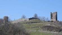 |
Ruins of Freudenberg Castle | 756.220 | 208.540 | 47°00′34″N 9°29′36″E / 47.009504°N 9.493228°E |
Balgach
| KGS No.? |
Picture | Name | Street Address | CH1903 X coordinate | CH1903 Y coordinate | Location |
|---|---|---|---|---|---|---|
| 8092 |  |
Old Rathaus (Town council house) | Steigstrasse 17 | 763.654 | 253.054 | 47°24′29″N 9°36′26″E / 47.407951°N 9.607131°E |
| Unknown | ISOS Spezialfall: Schlosslandschaft Ober-/ Unterrheintal (Altstätten, Balgach, Berneck, Marbach) |
|||||
| Unknown | ISOS Verstädtertes Dorf: Balgach / Herrbrugg |
Berg
| KGS No.? |
Picture | Name | Street Address | CH1903 X coordinate | CH1903 Y coordinate | Location |
|---|---|---|---|---|---|---|
| 9509 | Kleiner Hahnberg Castle | 748.980 | 262.316 | 47°29′41″N 9°24′57″E / 47.494711°N 9.415868°E | ||
| Unknown | ISOS Weiler: Zwingensteinhueb | |||||
| Unknown | ISOS Spezialfall: Hahnberg | |||||
| Unknown | ISOS Spezialfall: Schlosslandschaft Rorschach / Alter Rhein (Berg, Goldach, Mörschwil, Rheineck, Rorschacherberg, St. Margrethen, Steinach, Thal, Tübach) |
Berneck
| KGS No.? |
Picture | Name | Street Address | CH1903 X coordinate | CH1903 Y coordinate | Location |
|---|---|---|---|---|---|---|
| Unknown | ISOS Verstädtertes Dorf: Berneck | |||||
| Unknown | ISOS Spezialfall: Schlosslandschaft Ober-/ Unterrheintal (Altstätten, Balgach, Berneck, Marbach) |
|||||
| Unknown | ISOS Verstädtertes Dorf: Balgach / Herrbrugg |
Buchs
| KGS No.? |
Picture | Name | Street Address | CH1903 X coordinate | CH1903 Y coordinate | Location |
|---|---|---|---|---|---|---|
| Unknown | ISOS Spezialfall: Werdenberg Buchs |
Bütschwil-Ganterschwil
| KGS No.? |
Picture | Name | Street Address | CH1903 X coordinate | CH1903 Y coordinate | Location |
|---|---|---|---|---|---|---|
| Unknown | ISOS Urban Village: Bütschwil |
Degersheim
| KGS No.? |
Picture | Name | Street Address | CH1903 X coordinate | CH1903 Y coordinate | Location |
|---|---|---|---|---|---|---|
| 8114 |  |
Former Parish Church of St. Verena | Magdenau | 730.480 | 251.420 | 47°24′02″N 9°10′02″E / 47.400667°N 9.167237°E |
| 8112 | |
Cistercian Nuns Convent of Magdenau | Magdenau | 730.722 | 251.623 | 47°24′09″N 9°10′14″E / 47.402444°N 9.170502°E |
| Unknown | ISOS Verstädtertes Dorf: Degersheim | |||||
| Unknown | ISOS Spezialfall: Magdenau |
Ebnat-Kappel
| KGS No.? |
Picture | Name | Street Address | CH1903 X coordinate | CH1903 Y coordinate | Location |
|---|---|---|---|---|---|---|
| Unknown | ISOS Verstädtertes Dorf: Ebnat-Kappel | |||||
| Unknown | ISOS Spezialfall: Trempel |
Eggersriet
| KGS No.? |
Picture | Name | Street Address | CH1903 X coordinate | CH1903 Y coordinate | Location |
|---|---|---|---|---|---|---|
| Unknown | ISOS Weiler: Fürschwendi |
Eschenbach
| KGS No.? |
Picture | Name | Street Address | CH1903 X coordinate | CH1903 Y coordinate | Location |
|---|---|---|---|---|---|---|
| 8120 | Kusterhaus (Landrichterhaus) | Dorfstrasse 13 | 712.320 | 233.140 | 47°14′23″N 8°55′20″E / 47.239625°N 8.922136°E | |
| 10481 | Ruins of Fründsberg Castle | 713.675 | 238.055 | 47°17′01″N 8°56′29″E / 47.283593°N 8.941272°E | ||
| Unknown | ISOS Weiler: Gibel |
Flawil
| KGS No.? |
Picture | Name | Street Address | CH1903 X coordinate | CH1903 Y coordinate | Location |
|---|---|---|---|---|---|---|
| 8125 |  |
«Altes Rathaus» | Burgau | 733.630 | 252.072 | 47°24′21″N 9°12′33″E / 47.405898°N 9.20915°E |
| 9401 |  |
Gasthof Hirschen | Oberglatt | 733.370 | 252.666 | 47°24′41″N 9°12′21″E / 47.411292°N 9.205883°E |
| Unknown | ISOS Weiler: Burgau | |||||
| Unknown | ISOS Weiler: Raaschberg | |||||
| Unknown | ISOS Spezialfall: Oberglatt |
Flums
| KGS No.? |
Picture | Name | Street Address | CH1903 X coordinate | CH1903 Y coordinate | Location |
|---|---|---|---|---|---|---|
| 9650 |  |
Gräpplang Castle, Prehistoric Settlement, Medieval Ruined Castle |
743.750 | 218.620 | 47°06′11″N 9°19′57″E / 47.102967°N 9.332489°E | |
| 8134 | Chapel of St. Jakob | St. Jakob | 743.327 | 218.273 | 47°06′00″N 9°19′37″E / 47.099938°N 9.326808°E | |
| 8130 | Catholic Church of St. Justus | Marktstrasse | 744.710 | 217.300 | 47°05′27″N 9°20′41″E / 47.090888°N 9.344709°E | |
| Unknown | ISOS Verstädtertes Dorf: Flums |
Gaiserwald
| KGS No.? |
Picture | Name | Street Address | CH1903 X coordinate | CH1903 Y coordinate | Location |
|---|---|---|---|---|---|---|
| 8135 |  |
Catholic Parish Church of St. Josef | 742.260 | 254.030 | 47°25′18″N 9°19′27″E / 47.421696°N 9.324074°E |
Goldach
| KGS No.? |
Picture | Name | Street Address | CH1903 X coordinate | CH1903 Y coordinate | Location |
|---|---|---|---|---|---|---|
| Unknown | ISOS Spezialfall: Schlosslandschaft Rorschach / Alter Rhein (Berg, Goldach, Mörschwil, Rheineck, Rorschacherberg, St. Margrethen, Steinach, Thal, Tübach) |
Gommiswald
| KGS No.? |
Picture | Name | Street Address | CH1903 X coordinate | CH1903 Y coordinate | Location |
|---|---|---|---|---|---|---|
| Unknown | ISOS Spezialfall: Uetliburg / Berg Sion |
Gossau
| KGS No.? |
Picture | Name | Street Address | CH1903 X coordinate | CH1903 Y coordinate | Location |
|---|---|---|---|---|---|---|
| 9039 |  |
Former Gummibandweberei (Rubber Band Factory) |
Stadtbühlstrasse 12 | 736.726 | 252.840 | 47°24′44″N 9°15′01″E / 47.412168°N 9.250391°E |
| Unknown | ISOS Verstädtertes Dorf: Gossau (SG) | |||||
| Unknown | ISOS Spezialfall: Landscapes Matten/Wilen/Zinggenhueb (Andwil, Gossau) |
Grabs
| KGS No.? |
Picture | Name | Street Address | CH1903 X coordinate | CH1903 Y coordinate | Location |
|---|---|---|---|---|---|---|
| 8151 | Mill, Saw mill, Wool Washing Station and Hammermill | Glockenweg | 751.560 | 227.420 | 47°10′49″N 9°26′18″E / 47.180355°N 9.438295°E | |
| 11773 |  |
Double House | Werdenberg: Städtli 24, 25 | 753.459 | 226.127 | 47°10′06″N 9°27′46″E / 47.168291°N 9.462899°E |
| 11771 | 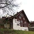 |
House | Werdenberg: Städtli 16 | 753.419 | 226.053 | 47°10′03″N 9°27′44″E / 47.167634°N 9.462347°E |
| 11772 |  |
House | Werdenberg: Städtli 23 | 753.445 | 226.102 | 47°10′05″N 9°27′46″E / 47.168069°N 9.462706°E |
| 11760 |  |
Row of Medieval Houses | Werdenberg: Städtli 2–7 | 753.467 | 226.106 | 47°10′05″N 9°27′47″E / 47.1681°N 9.462998°E |
| 10127 |  |
«Schlangenhaus» | Werdenberg: Städtli 14 | 753.432 | 226.045 | 47°10′03″N 9°27′45″E / 47.16756°N 9.462515°E |
| 8149 |  |
Werdenberg Castle | Werdenberg | 753.366 | 226.145 | 47°10′07″N 9°27′42″E / 47.168474°N 9.461679°E |
| 10126 |  |
Werdenberg City Walls | Werdenberg | 753.470 | 226.130 | 47°10′06″N 9°27′47″E / 47.168315°N 9.463045°E |
| Unknown | ISOS Spezialfall: Werdenberg (Buchs |
Hemberg
| KGS No.? |
Picture | Name | Street Address | CH1903 X coordinate | CH1903 Y coordinate | Location |
|---|---|---|---|---|---|---|
| 10128 |  |
«Rotes Haus» | Bächli, Brugg 693 | 732.243 | 240.188 | 47°17′58″N 9°11′14″E / 47.299315°N 9.187271°E |
| Unknown | ISOS Dorf: Hemberg |
Kirchberg
| KGS No.? |
Picture | Name | Street Address | CH1903 X coordinate | CH1903 Y coordinate | Location |
|---|---|---|---|---|---|---|
| 10129 |  |
Catholic Parish and Pilgrimage Church of St Peter Und Paul | Wilerstrasse | 720.885 | 252.442 | 47°24′42″N 9°02′26″E / 47.411688°N 9.040434°E |
| Unknown | ISOS Weiler: Bäbikon |
Lichtensteig
| KGS No.? |
Picture | Name | Street Address | CH1903 X coordinate | CH1903 Y coordinate | Location |
|---|---|---|---|---|---|---|
| 8178 |  |
Old Rathaus (Town council house) | Hintergasse 22 | 724.592 | 242.636 | 47°19′22″N 9°05′13″E / 47.322818°N 9.086812°E |
| Unknown | ISOS Kleinstadt / Flecken (Lichtensteig |
Lütisburg
| KGS No.? |
Picture | Name | Street Address | CH1903 X coordinate | CH1903 Y coordinate | Location |
|---|---|---|---|---|---|---|
| Unknown | ISOS Spezialfall: Lütisburg |
Marbach
| KGS No.? |
Picture | Name | Street Address | CH1903 X coordinate | CH1903 Y coordinate | Location |
|---|---|---|---|---|---|---|
| Unknown | ISOS Dorf: Marbach | |||||
| Unknown | ISOS Spezialfall: Schlosslandschaft Ober-/ Unterrheintal (Altstätten, Balgach, Berneck, Marbach) |
Mels
| KGS No.? |
Picture | Name | Street Address | CH1903 X coordinate | CH1903 Y coordinate | Location |
|---|---|---|---|---|---|---|
| 8189 | Castels Prehistoric to Medieval Hilltop Settlement |
749.930 | 212.825 | 47°02′58″N 9°24′43″E / 47.049487°N 9.411955°E | ||
| 9651 | Early Medieval Church of St Peter and Paul | 750.725 | 212.520 | 47°02′48″N 9°25′20″E / 47.046564°N 9.422313°E | ||
| Unknown | ISOS Verstädtertes Dorf: Mels | |||||
| Unknown | ISOS Dorf: Weisstannen |
Mörschwil
| KGS No.? |
Picture | Name | Street Address | CH1903 X coordinate | CH1903 Y coordinate | Location |
|---|---|---|---|---|---|---|
| Unknown | ISOS Spezialfall: Schlosslandschaft Rorschach / Alter Rhein (Berg, Goldach, Mörschwil, Rheineck, Rorschacherberg, St. Margrethen, Steinach, Thal, Tübach) |
Muolen
| KGS No.? |
Picture | Name | Street Address | CH1903 X coordinate | CH1903 Y coordinate | Location |
|---|---|---|---|---|---|---|
| Unknown | ISOS Spezialfall: Kulturlandschaft Unteregg / Rotzenwil / Hueb u.a. |
Neckertal
| KGS No.? |
Picture | Name | Street Address | CH1903 X coordinate | CH1903 Y coordinate | Location |
|---|---|---|---|---|---|---|
| 8194 | 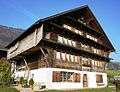 |
Haus Näf | Furth: Furt 520 | 729.375 | 243.310 | 47°19′41″N 9°09′01″E / 47.327958°N 9.15026°E |
| 8195 |  |
Oberes Türmlihaus | Furth: Furtstrasse 93 | 729.836 | 243.289 | 47°19′40″N 9°09′23″E / 47.327679°N 9.156351°E |
| 10141 | 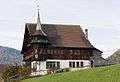 |
Unteres Türmlihaus | Furth: Furtstrasse 95 | 729.744 | 243.262 | 47°19′39″N 9°09′18″E / 47.327454°N 9.155126°E |
| Unknown | ISOS Dorf: Mogelsberg | |||||
| Unknown | ISOS Spezialfall: Spreitenbach / Furth |
Nesslau
| KGS No.? |
Picture | Name | Street Address | CH1903 X coordinate | CH1903 Y coordinate | Location |
|---|---|---|---|---|---|---|
| 10142 | House | Neu St. Johann: Sidwaldstrasse 6 | 732.937 | 232.568 | 47°13′50″N 9°11′39″E / 47.230654°N 9.194191°E | |
| 8176 |  |
Former Benedictine Abbey | Neu St. Johann: Johanneumstrasse 1, 3 | 732.888 | 232.398 | 47°13′45″N 9°11′37″E / 47.229135°N 9.193494°E |
| Unknown | ISOS Dorf: Ennetbühl |
Niederbüren
| KGS No.? |
Picture | Name | Street Address | CH1903 X coordinate | CH1903 Y coordinate | Location |
|---|---|---|---|---|---|---|
| 8519 | 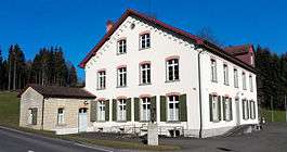 |
Textile Museum in Sorntal | 735.146 | 259.658 | 47°28′26″N 9°13′53″E / 47.4738°N 9.231525°E | |
| 10143 |  |
House | Staatsstrasse 35 | 733.066 | 258.808 | 47°28′00″N 9°12′13″E / 47.466581°N 9.203686°E |
Niederhelfenschwil
| KGS No.? |
Picture | Name | Street Address | CH1903 X coordinate | CH1903 Y coordinate | Location |
|---|---|---|---|---|---|---|
| 8205 |  |
Catholic Parish Church of St. Johannes Baptist | 731.792 | 259.840 | 47°28′34″N 9°11′14″E / 47.476117°N 9.187098°E | |
| 8206 |  |
Zuckenriet Castle | 729.994 | 261.197 | 47°29′19″N 9°09′49″E / 47.488677°N 9.163647°E |
Oberriet
| KGS No.? |
Picture | Name | Street Address | CH1903 X coordinate | CH1903 Y coordinate | Location |
|---|---|---|---|---|---|---|
| 8213 | |
Montlingerberg, Prehistoric Hilltop Settlement |
762.360 | 245.140 | 47°20′14″N 9°35′14″E / 47.337117°N 9.587123°E | |
| 8215 | |
Ruins of Wichenstein Castle | 759.880 | 243.960 | 47°19′38″N 9°33′14″E / 47.327113°N 9.5539°E |
Oberuzwil
| KGS No.? |
Picture | Name | Street Address | CH1903 X coordinate | CH1903 Y coordinate | Location |
|---|---|---|---|---|---|---|
| Unknown | ISOS Weiler: Niederglatt |
Pfäfers
| KGS No.? |
Picture | Name | Street Address | CH1903 X coordinate | CH1903 Y coordinate | Location |
|---|---|---|---|---|---|---|
| 8222 | Old Mineral Baths with Chapel | Bad Pfäfers | 755.923 | 204.562 | 46°58′26″N 9°29′17″E / 46.973803°N 9.487957°E | |
| 8225 | 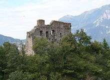 |
Ruins of Wartenstein Castle | 757.600 | 206.880 | 46°59′39″N 9°30′39″E / 46.994251°N 9.510793°E | |
| 8223 |  |
Former Benedictine Abbey | 756.965 | 206.425 | 46°59′25″N 9°30′08″E / 46.99031°N 9.50229°E | |
| 8224 | Drachenloch, Paleolithic Cave | Vättis | 750.440 | 199.060 | 46°55′32″N 9°24′51″E / 46.925593°N 9.414103°E | |
| Unknown | ISOS Dorf: Vättis |
Rapperswil-Jona
| KGS No.? |
Picture | Name | Street Address | CH1903 X coordinate | CH1903 Y coordinate | Location |
|---|---|---|---|---|---|---|
| 8158 |  |
Chapel of St. Dionys | St Dionysstrasse | 707.760 | 231.686 | 47°13′38″N 8°51′42″E / 47.227308°N 8.861574°E |
| 8242 |  |
Kempraten, Roman era Vicus |
704.630 | 232.595 | 47°14′10″N 8°49′14″E / 47.235986°N 8.820463°E | |
| 8234, 8573 |  |
Rapperswil Castle and Archive/Library in the Polenmuseum |
704.270 | 231.621 | 47°13′38″N 8°48′56″E / 47.227284°N 8.815484°E | |
| 8233 |  |
Rathaus (Town council house) of Rapperswil | Hauptplatz 1 | 704.334 | 231.511 | 47°13′35″N 8°48′59″E / 47.226284°N 8.816303°E |
| 9652 | 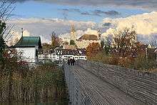 |
Seedamm, Prehistoric and Medieval Bridge |
704.020 | 230.945 | 47°13′16″N 8°48′43″E / 47.221244°N 8.812027°E | |
| Unknown |  |
ISOS Kleinstadt / Flecken: Rapperswil | ||||
| Unknown |  |
ISOS Spezialfall: Bollingen |
Rheineck
| KGS No.? |
Picture | Name | Street Address | CH1903 X coordinate | CH1903 Y coordinate | Location |
|---|---|---|---|---|---|---|
| 8248 |  |
Löwenhof | Rorschacherstrasse 15 | 761.928 | 259.679 | 47°28′05″N 9°35′12″E / 47.467941°N 9.586675°E |
| Unknown | ISOS Kleinstadt / Flecken: Rheineck | |||||
| Unknown | ISOS Spezialfall: Schlosslandschaft Rorschach / Alter Rhein (Berg, Goldach, Mörschwil, Rheineck, Rorschacherberg, St. Margrethen, Steinach, Thal, Tübach) |
Rieden
| KGS No.? |
Picture | Name | Street Address | CH1903 X coordinate | CH1903 Y coordinate | Location |
|---|---|---|---|---|---|---|
| Unknown | ISOS Dorf: Rieden |
Rorschach
| KGS No.? |
Picture | Name | Street Address | CH1903 X coordinate | CH1903 Y coordinate | Location |
|---|---|---|---|---|---|---|
| 8259 | 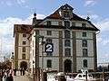 |
Former Granary | Hauptstrasse 58 | 754.744 | 260.749 | 47°28′45″N 9°29′30″E / 47.479291°N 9.49179°E |
| 8258 | 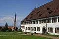 |
Former Benedictine Abbey of Mariaberg now Kantonales Lehrerseminar |
Seminarstrasse 27 | 754.991 | 260.013 | 47°28′21″N 9°29′41″E / 47.472615°N 9.49481°E |
| Unknown | ISOS Kleinstadt / Flecken: Rorschach | |||||
| Unknown | ISOS Spezialfall: Schlosslandschaft Rorschach / Alter Rhein (Berg, Goldach, Mörschwil, Rheineck, Rorschacherberg, St. Margrethen, Steinach, Thal, Tübach) |
Rorschacherberg
| KGS No.? |
Picture | Name | Street Address | CH1903 X coordinate | CH1903 Y coordinate | Location |
|---|---|---|---|---|---|---|
| Unknown | ISOS Spezialfall: Schlosslandschaft Rorschach / Alter Rhein (Berg, Goldach, Mörschwil, Rheineck, Rorschacherberg, St. Margrethen, Steinach, Thal, Tübach) |
Rüthi
| KGS No.? |
Picture | Name | Street Address | CH1903 X coordinate | CH1903 Y coordinate | Location |
|---|---|---|---|---|---|---|
| Unknown | ISOS Dorf: Rüthi (SG) |
Sargans
| KGS No.? |
Picture | Name | Street Address | CH1903 X coordinate | CH1903 Y coordinate | Location |
|---|---|---|---|---|---|---|
| 8272 |  |
Gonzen Bergwerke, Mine, Ruins and Gravel Works |
752.900 | 213.800 | 47°03′27″N 9°27′05″E / 47.057576°N 9.451358°E | |
| 8270 |  |
Sargans Castle | 751.851 | 212.957 | 47°03′01″N 9°26′14″E / 47.050237°N 9.437272°E | |
| Unknown | ISOS Kleinstadt / Flecken: Sargans |
Schänis
| KGS No.? |
Picture | Name | Street Address | CH1903 X coordinate | CH1903 Y coordinate | Location |
|---|---|---|---|---|---|---|
| 8277 | Biberlikopf, Roman era Watch Tower |
723.720 | 221.480 | 47°07′58″N 9°04′10″E / 47.132732°N 9.069465°E | ||
| 8282 |  |
Former Damenstift (Women's Collegiate Foundation) zum Heiligen Kreuz |
Rathausplatz 1 | 721.828 | 224.469 | 47°09′36″N 9°02′43″E / 47.159963°N 9.045339°E |
| 8278 |  |
Gallusturm (Tower) | Gallusgasse | 721.935 | 224.604 | 47°09′40″N 9°02′48″E / 47.161157°N 9.046786°E |
| Unknown | ISOS Dorf: Schänis | |||||
| Unknown | ISOS Weiler: Maseltrangen |
Schmerikon
| KGS No.? |
Picture | Name | Street Address | CH1903 X coordinate | CH1903 Y coordinate | Location |
|---|---|---|---|---|---|---|
| Unknown | ISOS Dorf: Schmerikon |
St. Gallen
| KGS No.? |
Picture | Name | Street Address | CH1903 X coordinate | CH1903 Y coordinate | Location |
|---|---|---|---|---|---|---|
| 8314 |  |
Broderbrunnen (Fountain) | St. Leonhard-Strasse / Oberer Graben | 746.009 | 254.369 | 47°25′26″N 9°22′26″E / 47.423923°N 9.373853°E |
| 8295 |  |
Former Dominican Nuns Convent of St. Katharina | 746.236 | 254.731 | 47°25′38″N 9°22′37″E / 47.427128°N 9.376979°E | |
| 8304 |  |
Railroad Bridge Bodensee-Toggenburgbahn (Shared with Herisau) | 742.388 | 251.672 | 47°24′02″N 9°19′30″E / 47.400466°N 9.325019°E | |
| 8306 | Eisensteg Zweibruggen (Shared with Stein) | Haggenstrasse | 743.472 | 251.626 | 47°23′59″N 9°20′22″E / 47.399817°N 9.33936°E | |
| 8354 |  |
Geschäftshaus Oceanic | St. Leonhard-Strasse 20 | 745.879 | 254.290 | 47°25′24″N 9°22′20″E / 47.423242°N 9.372105°E |
| 8355 |  |
Geschäftshaus Washington | Rosenbergstrasse 20, 22 | 745.832 | 254.539 | 47°25′32″N 9°22′18″E / 47.425491°N 9.371563°E |
| 8296 |  |
Main Train Station | Bahnhofplatz 2 | 745.705 | 254.283 | 47°25′24″N 9°22′11″E / 47.423217°N 9.369797°E |
| 8297 |  |
Main Post Office | Bahnhofplatz 5 | 745.714 | 254.199 | 47°25′21″N 9°22′12″E / 47.42246°N 9.369889°E |
| 8513 |  |
Historisches Museum and Völkerkundemuseum | Museumstrasse 50 | 746.682 | 254.913 | 47°25′43″N 9°22′59″E / 47.428665°N 9.382948°E |
| 8299, 8815, 9342 | Cantonal Library and City Archives (Vadiana) | Notkerstrasse 22 | 746.613 | 254.967 | 47°25′45″N 9°22′55″E / 47.429166°N 9.382052°E | |
| 8333 |  |
Kantonsschule St. Gallen | Burggraben 21 | 746.485 | 254.554 | 47°25′32″N 9°22′49″E / 47.425481°N 9.38022°E |
| 10154 |  |
Catholic Parish Church of St. Maria Neudorf | Rorschacherstrasse 257 | 748.492 | 256.066 | 47°26′19″N 9°24′26″E / 47.438626°N 9.407314°E |
| 8310 |  |
Kräzern-Strassenbrücke with Zollhaus | Krätzernstrasse | 742.150 | 252.320 | 47°24′23″N 9°19′19″E / 47.406344°N 9.322073°E |
| 8302, 8516, 8517 |  |
Art Museum and Natural History Museum | Museumstrasse 32 | 746.583 | 254.814 | 47°25′40″N 9°22′54″E / 47.427797°N 9.381604°E |
| 9511 |  |
Lokremise with Wasserturm | Grünbergstrasse 7 | 745.400 | 254.082 | 47°25′17″N 9°21′56″E / 47.421478°N 9.365691°E |
| 9654 |  |
Medieval / Early Modern City | 746.240 | 254.400 | 47°25′27″N 9°22′37″E / 47.424151°N 9.376924°E | |
| 8552 |  |
Museum in Lagerhaus | Davidstrasse 44 | 745.517 | 253.887 | 47°25′11″N 9°22′02″E / 47.419698°N 9.367178°E |
| 8303 | 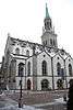 |
Swiss Reformed of St. Laurenzenkirche | Marktgasse 25 | 746.245 | 254.430 | 47°25′28″N 9°22′37″E / 47.424419°N 9.377°E |
| 8776, 8795 |  |
State Archives of the Canton of St. Gallen | Klosterhof 1 | 746.295 | 254.382 | 47°25′26″N 9°22′40″E / 47.423977°N 9.377646°E |
| 8995 |  |
City Theater | Museumsstrasse 24 | 746.501 | 254.716 | 47°25′37″N 9°22′50″E / 47.426934°N 9.380485°E |
| 8775, 9343, 8312 |  |
Collegiate Buildings with Cathedral and Library | Klosterhof 1–8 | 746.297 | 254.343 | 47°25′25″N 9°22′40″E / 47.423626°N 9.37766°E |
| 8515 |  |
Textile Museum | Vadianstrasse 2 | 745.986 | 254.307 | 47°25′24″N 9°22′25″E / 47.423371°N 9.373528°E |
| 8348 |  |
Tröckneturm | Burgweiherweg 569 | 744.111 | 253.441 | 47°24′58″N 9°20′54″E / 47.415997°N 9.348407°E |
| 8331 |  |
University of St. Gallen (HSG) | Dufourstrasse 48, 50 | 746.033 | 255.229 | 47°25′54″N 9°22′28″E / 47.431651°N 9.374452°E |
| 8352 | Volksbad | Volksbadstrasse 4, 6 | 746.806 | 254.889 | 47°25′42″N 9°23′04″E / 47.428422°N 9.384583°E | |
| Unknown | ISOS Spezialfall: Bruggen / Sittertal | |||||
| Unknown | ISOS Spezialfall: Landscapes Kapf / Notkersegg |
St. Margrethen
| KGS No.? |
Picture | Name | Street Address | CH1903 X coordinate | CH1903 Y coordinate | Location |
|---|---|---|---|---|---|---|
| 8358 |  |
Old St. Margaretha Church | 764.605 | 258.377 | 47°27′20″N 9°37′18″E / 47.455571°N 9.621688°E | |
| Unknown | ISOS Spezialfall: Schlosslandschaft Rorschach / Alter Rhein (Berg, Goldach, Mörschwil, Rheineck, Rorschacherberg, St. Margrethen, Steinach, Thal, Tübach) |
Steinach
| KGS No.? |
Picture | Name | Street Address | CH1903 X coordinate | CH1903 Y coordinate | Location |
|---|---|---|---|---|---|---|
| Unknown | ISOS Spezialfall: Schlosslandschaft Rorschach / Alter Rhein (Berg, Goldach, Mörschwil, Rheineck, Rorschacherberg, St. Margrethen, Steinach, Thal, Tübach) |
Thal
| KGS No.? |
Picture | Name | Street Address | CH1903 X coordinate | CH1903 Y coordinate | Location |
|---|---|---|---|---|---|---|
| Unknown | ISOS Dorf: Thal / Feldmoos | |||||
| Unknown | ISOS Spezialfall: Landscapes Buechberg / Buechstig | |||||
| Unknown | ISOS Spezialfall: Schlosslandschaft Rorschach / Alter Rhein (Berg, Goldach, Mörschwil, Rheineck, Rorschacherberg, St. Margrethen, Steinach, Thal, Tübach) |
Tübach
| KGS No.? |
Picture | Name | Street Address | CH1903 X coordinate | CH1903 Y coordinate | Location |
|---|---|---|---|---|---|---|
| 8373 |  |
Capuchin Nuns Convent of St. Scholastika | Schulstrasse 38 | 751.863 | 260.861 | 47°28′51″N 9°27′13″E / 47.480969°N 9.453619°E |
| Unknown | ISOS Spezialfall: Schlosslandschaft Rorschach / Alter Rhein (Berg, Goldach, Mörschwil, Rheineck, Rorschacherberg, St. Margrethen, Steinach, Thal, Tübach) |
Untereggen
| KGS No.? |
Picture | Name | Street Address | CH1903 X coordinate | CH1903 Y coordinate | Location |
|---|---|---|---|---|---|---|
| Unknown | ISOS Spezialfall: Sulzberg |
Uzwil
| KGS No.? |
Picture | Name | Street Address | CH1903 X coordinate | CH1903 Y coordinate | Location |
|---|---|---|---|---|---|---|
| 8518 | Hauser & Wirth Collection Henau | Felseggstrasse 51 | 726.790 | 258.221 | 47°27′45″N 9°07′13″E / 47.462543°N 9.120297°E | |
| 8382 | Villa Waldbühl | Waldbühl 996 | 727.565 | 256.327 | 47°26′43″N 9°07′48″E / 47.445362°N 9.130032°E |
Waldkirch
| KGS No.? |
Picture | Name | Street Address | CH1903 X coordinate | CH1903 Y coordinate | Location |
|---|---|---|---|---|---|---|
| 8386 | Catholic Parish Church of St. Johannes Baptist | Bernhardzell, Kirchstrasse | 743.050 | 259.850 | 47°28′26″N 9°20′11″E / 47.473855°N 9.336405°E |
Walenstadt
| KGS No.? |
Picture | Name | Street Address | CH1903 X coordinate | CH1903 Y coordinate | Location |
|---|---|---|---|---|---|---|
| 8390, 9655 |  |
St. Georgenberg, Prehistoric-Early Middle Ages Hilltop Settlement and St. Georg Chapel |
745.170 | 218.530 | 47°06′07″N 9°21′04″E / 47.101848°N 9.351161°E | |
| Unknown | ISOS Kleinstadt / Flecken: Walenstadt |
Wartau
| KGS No.? |
Picture | Name | Street Address | CH1903 X coordinate | CH1903 Y coordinate | Location |
|---|---|---|---|---|---|---|
| 8396 | 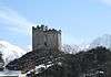 |
Gretschins-Herrenfeld / Ochsenberg Prehistoric Settlement and Sacrifice Site Medieval Fortress and Ruins |
755.750 | 218.420 | 47°05′54″N 9°29′26″E / 47.098455°N 9.490448°E | |
| 8397 | 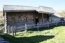 |
So-Called Walser Rathaus (Town council house) auf Palfries | 748.974 | 218.058 | 47°05′48″N 9°24′04″E / 47.096759°N 9.401101°E | |
| Unknown | ISOS Dorf: Azmoos | |||||
| Unknown | ISOS Dorf: Oberschan | |||||
| Unknown | ISOS Weiler: Fontnas | |||||
| Unknown | ISOS Weiler: Gretschins |
Wattwil
| KGS No.? |
Picture | Name | Street Address | CH1903 X coordinate | CH1903 Y coordinate | Location |
|---|---|---|---|---|---|---|
| Unknown | ISOS Verstädtertes Dorf: Wattwil | |||||
| Unknown | ISOS Kleinstadt / Flecken (Lichtensteig |
Weesen
| KGS No.? |
Picture | Name | Street Address | CH1903 X coordinate | CH1903 Y coordinate | Location |
|---|---|---|---|---|---|---|
| 9656 | Altweesen, late-Roman era Castle/Medieval Abandoned Settlement |
725.480 | 221.515 | 47°07′58″N 9°05′34″E / 47.132715°N 9.092667°E | ||
| Unknown | ISOS Kleinstadt / Flecken: Weesen |
Wil
| KGS No.? |
Picture | Name | Street Address | CH1903 X coordinate | CH1903 Y coordinate | Location |
|---|---|---|---|---|---|---|
| 8413 |  |
Baronenhaus | Marktgasse 73 | 721.479 | 258.636 | 47°28′02″N 9°03′00″E / 47.467276°N 9.049988°E |
| 9341 | Dominican Nuns Convent of St. Katharina | Bibliothek, | 721.501 | 258.366 | 47°27′53″N 9°03′01″E / 47.464844°N 9.050206°E | |
| 8414 |  |
Hof | Marktgasse 88, 90 | 721.485 | 258.680 | 47°28′04″N 9°03′00″E / 47.467671°N 9.050079°E |
| 8106 |  |
Pilgrimage Church of Maria-Hilf | Dreibrunnen, Kapellstrasse | 719.580 | 259.072 | 47°28′18″N 9°01′30″E / 47.471545°N 9.024922°E |
| Unknown | ISOS Kleinstadt / Flecken: Wil |
Wildhaus-Alt St. Johann
| KGS No.? |
Picture | Name | Street Address | CH1903 X coordinate | CH1903 Y coordinate | Location |
|---|---|---|---|---|---|---|
| 8071 | 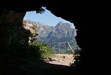 |
Wildenmannlisloch, Paleolithic Cave | 737.730 | 225.690 | 47°10′04″N 9°15′19″E / 47.167823°N 9.255363°E | |
| 8422 |  |
Birth Place of Huldrych Zwingli | Wildhaus, Lisighus 167 | 744.059 | 229.520 | 47°12′03″N 9°20′24″E / 47.200915°N 9.340038°E |
Wittenbach
| KGS No.? |
Picture | Name | Street Address | CH1903 X coordinate | CH1903 Y coordinate | Location |
|---|---|---|---|---|---|---|
| Unknown | ISOS Weiler: Dottenwil / Unterrüti | |||||
| Unknown | ISOS Weiler: Unterlören |
References
- All entries, addresses and coordinates are from: "Kantonsliste A-Objekte". KGS Inventar (in German). Federal Office of Civil Protection. 2009. Retrieved 25 April 2011.
External links
- Swiss Inventory of Cultural Property of National and Regional Significance, 2009 edition:
- "Revision of the PCP Inventory (Revision des KGS-Inventars)". KGS Forum. Federal Office of Civil Protection (13/2008). 2008.
This article is issued from Wikipedia - version of the 8/12/2016. The text is available under the Creative Commons Attribution/Share Alike but additional terms may apply for the media files.