List of cultural property of national significance in Switzerland: Jura
This list contains all cultural property of national significance (class A) in the canton of Jura from the 2009 Swiss Inventory of Cultural Property of National and Regional Significance. It is sorted by municipality and contains 29 individual buildings, 6 collections and 11 archaeological finds.
The geographic coordinates provided are in the Swiss coordinate system as given in the Inventory.
Alle
| KGS No.? |
Picture | Name | Street Address | CH1903 X coordinate | CH1903 Y coordinate | Location |
|---|---|---|---|---|---|---|
| 3446 | Noir Bois Paleolithic and Medieval Settlement |
575.550 | 251.975 | 47°25′05″N 7°06′53″E / 47.418128°N 7.114644°E | ||
| 3447 | Pré Monsieur Paleolithic Settlement |
575.050 | 252.025 | 47°25′07″N 7°06′29″E / 47.418559°N 7.108016°E | ||
| Unknown | ISOS village urbanisé: Alle |
Basse-Allaine
| KGS No.? |
Picture | Name | Street Address | CH1903 X coordinate | CH1903 Y coordinate | Location |
|---|---|---|---|---|---|---|
| 3474 | _(2).jpg) |
Prairie Dessous Gallo-Roman Villa |
Buix village | 568.920 | 259.340 | 47°29′03″N 7°01′35″E / 47.484089°N 7.026278°E |
| 3550 |  |
Former Priory of Grandgourt | Montignez village | 570.529 | 257.868 | 47°28′15″N 7°02′52″E / 47.470924°N 7.047722°E |
| Unknown | ISOS village: Montignez | |||||
| Unknown | ISOS hameau: Le Maira | |||||
| Unknown | ISOS cas particulier: Grandgourt |
Boncourt
| KGS No.? |
Picture | Name | Street Address | CH1903 X coordinate | CH1903 Y coordinate | Location |
|---|---|---|---|---|---|---|
| 10069 |  |
Chavon-Dessous Farm House | Impasse Du Chavon-Dessous 1 | 567.927 | 260.741 | 47°29′48″N 7°00′47″E / 47.496642°N 7.013002°E |
Bourrignon
| KGS No.? |
Picture | Name | Street Address | CH1903 X coordinate | CH1903 Y coordinate | Location |
|---|---|---|---|---|---|---|
| Unknown | ISOS village: Bourrignon |
Clos du Doubs
| KGS No.? |
Picture | Name | Street Address | CH1903 X coordinate | CH1903 Y coordinate | Location |
|---|---|---|---|---|---|---|
| 10078 | Farm House | Montmelon, Chez Danville 5 | 580.994 | 245.538 | 47°21′37″N 7°11′13″E / 47.360412°N 7.187057°E | |
| 3557 |  |
Montvoie Castle | Ocourt | 571.150 | 246.190 | 47°21′57″N 7°03′24″E / 47.365919°N 7.056713°E |
| 3607 |  |
Saint-Ursanne Collegiate church, Cloister and former Church of St-Pierre |
578.460 | 246.030 | 47°21′53″N 7°09′13″E / 47.36476°N 7.153491°E | |
| 3618 | Saint-Ursanne town fortifications | 578.540 | 246.300 | 47°22′02″N 7°09′16″E / 47.367191°N 7.154537°E | ||
| 3614 |  |
Bridge over the Doubs | Saint-Ursanne, Rue de 3 Février / Route du Clos du Doubs |
578.560 | 245.950 | 47°21′51″N 7°09′17″E / 47.364043°N 7.154819°E |
| 9586 | 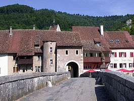 |
Saint-Ursanne, Medieval Village | 578.500 | 246.000 | 47°21′52″N 7°09′14″E / 47.364491°N 7.154022°E | |
| Unknown | ISOS petite Village / bourg: Saint-Ursanne | |||||
| Unknown | ISOS hameau: Montenol |
Coeuve
| KGS No.? |
Picture | Name | Street Address | CH1903 X coordinate | CH1903 Y coordinate | Location |
|---|---|---|---|---|---|---|
| Unknown | ISOS village: Coeuve |
Corban
| KGS No.? |
Picture | Name | Street Address | CH1903 X coordinate | CH1903 Y coordinate | Location |
|---|---|---|---|---|---|---|
| Unknown | ISOS village: Corban |
Cornol
| KGS No.? |
Picture | Name | Street Address | CH1903 X coordinate | CH1903 Y coordinate | Location |
|---|---|---|---|---|---|---|
| 3487 | Mont-Terri, Prehistoric Site / Medieval Castle |
579.050 | 248.970 | 47°23′28″N 7°09′40″E / 47.391222°N 7.161164°E |
Courgenay
| KGS No.? |
Picture | Name | Street Address | CH1903 X coordinate | CH1903 Y coordinate | Location |
|---|---|---|---|---|---|---|
| 9584 |  |
Pierre-Percée, Neolithic Dolmen |
575.850 | 250.630 | 47°24′22″N 7°07′07″E / 47.406042°N 7.118692°E |
Courrendlin
| KGS No.? |
Picture | Name | Street Address | CH1903 X coordinate | CH1903 Y coordinate | Location |
|---|---|---|---|---|---|---|
| Unknown | ISOS cas particulier: Choindez |
Courroux
| KGS No.? |
Picture | Name | Street Address | CH1903 X coordinate | CH1903 Y coordinate | Location |
|---|---|---|---|---|---|---|
| Unknown | ISOS hameau: Courcelon |
Delémont
| KGS No.? |
Picture | Name | Street Address | CH1903 X coordinate | CH1903 Y coordinate | Location |
|---|---|---|---|---|---|---|
| 3508 | 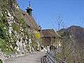 |
Vorbourg Chapel | Route Du Vorbourg 188 | 593.920 | 247.641 | 47°22′46″N 7°21′29″E / 47.379573°N 7.358128°E |
| 3509 | .jpg) |
Prince-Bishops' Castle | Rue du 23-Juin 21–25 | 592.768 | 245.886 | 47°21′50″N 7°20′34″E / 47.363777°N 7.342902°E |
| 3510 |  |
St-Marcel Church | Place de l‘Eglise 3 | 592.814 | 245.974 | 47°21′52″N 7°20′37″E / 47.364569°N 7.34351°E |
| 3511, 8685 |  |
Museum jurassien d’art et d’histoire et Tour Rouge | 23-Juin No 52 | 592.700 | 245.961 | 47°21′52″N 7°20′31″E / 47.36445°N 7.342001°E |
| 3527 |  |
Rotunda for Locomotives, Carriage house | remises | 594.000 | 245.850 | 47°21′48″N 7°21′33″E / 47.363465°N 7.359211°E |
| Unknown | ISOS petite Village / bourg: Delémont |
Fahy
| KGS No.? |
Picture | Name | Street Address | CH1903 X coordinate | CH1903 Y coordinate | Location |
|---|---|---|---|---|---|---|
| 10070 |  |
Farm House | Bout-Dessous 18 | 563.339 | 252.001 | 47°25′04″N 6°57′10″E / 47.417796°N 6.952835°E |
| 10071 |  |
House | Bout-Dessous 19 | 563.319 | 251.981 | 47°25′03″N 6°57′09″E / 47.417615°N 6.952571°E |
| Unknown | ISOS village: Fahy |
Haute-Ajoie
| KGS No.? |
Picture | Name | Street Address | CH1903 X coordinate | CH1903 Y coordinate | Location |
|---|---|---|---|---|---|---|
| Unknown | ISOS village: Chevenez |
Haute-Sorne
| KGS No.? |
Picture | Name | Street Address | CH1903 X coordinate | CH1903 Y coordinate | Location |
|---|---|---|---|---|---|---|
| 3493 | 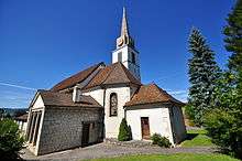 |
St-Germain-D‘Auxerre Church | Chemin Des Reus 1 | 588.227 | 242.590 | 47°20′03″N 7°16′58″E / 47.334066°N 7.282876°E |
| 10072 |  |
Farm House | Au Village 17 | 582.135 | 242.447 | 47°19′58″N 7°12′08″E / 47.332643°N 7.202283°E |
| 9585 |  |
Le Mont, Prehistoric Shelter (Shared with Saint-Brais) |
577.580 | 240.200 | 47°18′44″N 7°08′32″E / 47.312293°N 7.142133°E | |
| Unknown | ISOS village: Soulce | |||||
| Unknown | ISOS cas particulier: Les Forges |
La Baroche
| KGS No.? |
Picture | Name | Street Address | CH1903 X coordinate | CH1903 Y coordinate | Location |
|---|---|---|---|---|---|---|
| 3453 | 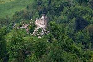 |
Asuel, Castle Ruins / Abandoned Village |
582.740 | 249.840 | 47°23′57″N 7°12′36″E / 47.399154°N 7.210003°E | |
| 10077 |  |
Farm House | Miécourt, Grand-Rue 101 | 580.112 | 252.941 | 47°25′37″N 7°10′30″E / 47.42697°N 7.175053°E |
| Unknown | ISOS village: Miécourt | |||||
| Unknown | ISOS cas particulier: Pleujouse |
La Chaux-des-Breuleux
| KGS No.? |
Picture | Name | Street Address | CH1903 X coordinate | CH1903 Y coordinate | Location |
|---|---|---|---|---|---|---|
| 10074 |  |
Farm House 22 | 568.957 | 230.009 | 47°13′13″N 7°01′44″E / 47.220282°N 7.0288°E | |
| Unknown | ISOS hameau: La Chaux-des-Breuleux |
Le Bémont
| KGS No.? |
Picture | Name | Street Address | CH1903 X coordinate | CH1903 Y coordinate | Location |
|---|---|---|---|---|---|---|
| 3457 |  |
Farm House | La Bosse No 38 | 568.200 | 235.500 | 47°16′11″N 7°01′06″E / 47.269634°N 7.018418°E |
| Unknown | ISOS hameau: La Bosse |
Le Noirmont
| KGS No.? |
Picture | Name | Street Address | CH1903 X coordinate | CH1903 Y coordinate | Location |
|---|---|---|---|---|---|---|
| 3555 |  |
Farm House | Les Esserts 32 | 562.586 | 229.331 | 47°12′50″N 6°56′41″E / 47.213854°N 6.944747°E |
| Unknown | ISOS village urbanisé: Le Noirmont |
Les Breuleux
| KGS No.? |
Picture | Name | Street Address | CH1903 X coordinate | CH1903 Y coordinate | Location |
|---|---|---|---|---|---|---|
| 3472 |  |
Farm House | Du Peu-Girard 46 A | 567.054 | 229.182 | 47°12′46″N 7°00′13″E / 47.212751°N 7.003737°E |
| 10075 |  |
Farm House | Sur le Cratan 13 | 567.000 | 229.000 | 47°12′40″N 7°00′11″E / 47.211111°N 7.003037°E |
Les Genevez
| KGS No.? |
Picture | Name | Street Address | CH1903 X coordinate | CH1903 Y coordinate | Location |
|---|---|---|---|---|---|---|
| 10076 | 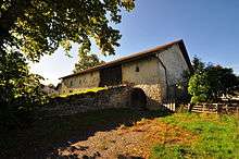 |
Farm House 35 | 576.600 | 233.900 | 47°15′20″N 7°07′46″E / 47.255594°N 7.129501°E | |
| 3539 | 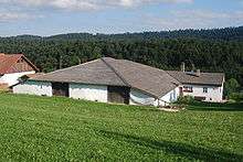 |
Rural Jurassien (Rural Jura Region) Museum | Les Clos dessus 10 | 576.809 | 234.293 | 47°15′33″N 7°07′56″E / 47.259137°N 7.132242°E |
Muriaux
| KGS No.? |
Picture | Name | Street Address | CH1903 X coordinate | CH1903 Y coordinate | Location |
|---|---|---|---|---|---|---|
| Unknown | ISOS village: Muriaux |
Pleigne
| KGS No.? |
Picture | Name | Street Address | CH1903 X coordinate | CH1903 Y coordinate | Location |
|---|---|---|---|---|---|---|
| 3558 | 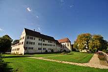 |
Former Priory of Löwenburg | Le Löwenburg 86 | 590.618 | 253.645 | 47°26′01″N 7°18′51″E / 47.433536°N 7.314278°E |
| 3559 | Löwenburg, Paleolithic Settlement and Neolithic Flint Mine |
591.400 | 254.050 | 47°26′14″N 7°19′29″E / 47.437189°N 7.324636°E | ||
| Unknown | ISOS cas particulier: Löwenburg |
Porrentruy
| KGS No.? |
Picture | Name | Street Address | CH1903 X coordinate | CH1903 Y coordinate | Location |
|---|---|---|---|---|---|---|
| 8784, 9334 | 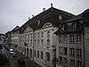 |
Archives of the Republic and Canton of Jura and the Jura cantonal library |
Rue Pierre-Péquignat 9 | 572.490 | 251.888 | 47°25′02″N 7°04′27″E / 47.417225°N 7.074102°E |
| 3567 |  |
Porrentruy Castle | 572.363 | 252.140 | 47°25′10″N 7°04′21″E / 47.419486°N 7.072403°E | |
| 3568 |  |
Church and College of the Jesuits | Place Blarer-de-Wartensee 2 | 572.609 | 251.556 | 47°24′51″N 7°04′33″E / 47.414244°N 7.075699°E |
| 3569 |  |
St-Pierre Church | Rue de l‘Eglise 15 | 572.680 | 251.733 | 47°24′57″N 7°04′36″E / 47.415839°N 7.076629°E |
| 3571, 8826 |  |
Hôtel de Gléresse and the Foundation Archives of the former Bishopric of Basel |
Rue des Annonciades No 10 | 572.528 | 251.727 | 47°24′57″N 7°04′29″E / 47.415779°N 7.074615°E |
| 3572, 8686 |  |
Hôtel-Dieu with pharmacy and museum | Grand‘Rue 5 | 572.597 | 251.824 | 47°25′00″N 7°04′32″E / 47.416654°N 7.075523°E |
| 8687 |  |
Jura Natural Sciences Museum and Garden | Route de Fontenais 21 | 572.770 | 251.553 | 47°24′51″N 7°04′40″E / 47.414224°N 7.077832°E |
| Unknown | ISOS petite Village / bourg: Porrentruy |
Rocourt
| KGS No.? |
Picture | Name | Street Address | CH1903 X coordinate | CH1903 Y coordinate | Location |
|---|---|---|---|---|---|---|
| Unknown | ISOS village: Rocourt |
Saignelégier
| KGS No.? |
Picture | Name | Street Address | CH1903 X coordinate | CH1903 Y coordinate | Location |
|---|---|---|---|---|---|---|
| Unknown | ISOS village: Les Pommerats | |||||
| Unknown | ISOS hameau: Les Cerlatez |
Saint-Brais
| KGS No.? |
Picture | Name | Street Address | CH1903 X coordinate | CH1903 Y coordinate | Location |
|---|---|---|---|---|---|---|
| 9585 | |
Le Mont, Prehistoric Settlement (Shared With Glovelier) |
576.800 | 239.975 | 47°18′37″N 7°07′55″E / 47.310243°N 7.13183°E |
References
- All entries, addresses and coordinates are from: "Kantonsliste A-Objekte". KGS Inventar (in German). Federal Office of Civil Protection. 2009. Retrieved 25 April 2011.
External links
- Swiss Inventory of Cultural Property of National and Regional Significance, 2009 edition:
- "Revision of the PCP Inventory (Revision des KGS-Inventars)". KGS Forum. Federal Office of Civil Protection (13/2008). 2008.
This article is issued from Wikipedia - version of the 8/12/2016. The text is available under the Creative Commons Attribution/Share Alike but additional terms may apply for the media files.