Lamoine, Maine
| Lamoine, Maine | |
|---|---|
| Town | |
|
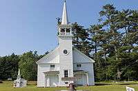
Located in a former school building is the Lamoine Town Hall, with Veterans Memorial to the left. | |
 Lamoine, Maine Location within the state of Maine | |
| Coordinates: 44°29′28″N 68°19′9″W / 44.49111°N 68.31917°WCoordinates: 44°29′28″N 68°19′9″W / 44.49111°N 68.31917°W | |
| Country | United States |
| State | Maine |
| County | Hancock |
| Area[1] | |
| • Total | 25.07 sq mi (64.93 km2) |
| • Land | 17.82 sq mi (46.15 km2) |
| • Water | 7.25 sq mi (18.78 km2) |
| Elevation | 148 ft (45 m) |
| Population (2010)[2] | |
| • Total | 1,602 |
| • Estimate (2012[3]) | 1,622 |
| • Density | 89.9/sq mi (34.7/km2) |
| Time zone | Eastern (EST) (UTC-5) |
| • Summer (DST) | EDT (UTC-4) |
| ZIP code | 04605 |
| Area code(s) | 207 |
| FIPS code | 23-38180 |
| GNIS feature ID | 0582549 |


Lamoine is a town in Hancock County, Maine, United States. The town was named after an early resident, Andre LeMoyne. The spelling shifted slightly over the years. "Le moine" is French for "the monk." [4] The population was 1,495 at the 2000 census; 1,602, at the 2010 census.[5]
Geography
According to the United States Census Bureau, the town has a total area of 25.07 square miles (64.93 km2), of which 17.82 square miles (46.15 km2) is land and 7.25 square miles (18.78 km2) is water.[1]
Demographics
| Historical population | |||
|---|---|---|---|
| Census | Pop. | %± | |
| 1870 | 612 | — | |
| 1880 | 749 | 22.4% | |
| 1890 | 726 | −3.1% | |
| 1900 | 594 | −18.2% | |
| 1910 | 482 | −18.9% | |
| 1920 | 327 | −32.2% | |
| 1930 | 354 | 8.3% | |
| 1940 | 454 | 28.2% | |
| 1950 | 443 | −2.4% | |
| 1960 | 484 | 9.3% | |
| 1970 | 615 | 27.1% | |
| 1980 | 953 | 55.0% | |
| 1990 | 1,311 | 37.6% | |
| 2000 | 1,495 | 14.0% | |
| 2010 | 1,602 | 7.2% | |
| Est. 2014 | 1,639 | [6] | 2.3% |
2010 census
As of the census[2] of 2010, there were 1,602 people, 712 households, and 460 families residing in the town. The population density was 89.9 inhabitants per square mile (34.7/km2). There were 994 housing units at an average density of 55.8 per square mile (21.5/km2). The racial makeup of the town was 98.0% White, 0.5% African American, 0.1% Native American, 0.5% Asian, 0.1% from other races, and 0.8% from two or more races. Hispanic or Latino of any race were 0.7% of the population.
There were 712 households of which 24.4% had children under the age of 18 living with them, 54.1% were married couples living together, 6.3% had a female householder with no husband present, 4.2% had a male householder with no wife present, and 35.4% were non-families. 25.0% of all households were made up of individuals and 8.1% had someone living alone who was 65 years of age or older. The average household size was 2.25 and the average family size was 2.68.
The median age in the town was 48 years. 17.9% of residents were under the age of 18; 4.8% were between the ages of 18 and 24; 22.2% were from 25 to 44; 37.9% were from 45 to 64; and 17.4% were 65 years of age or older. The gender makeup of the town was 48.8% male and 51.2% female.
2000 census
As of the census[8] of 2000, there were 1,495 people, 605 households, and 434 families residing in the town. The population density was 83.6 people per square mile (32.3/km²). There were 803 housing units at an average density of 44.9 per square mile (17.3/km²). The racial makeup of the town was 97.53% White, 0.27% African American, 0.54% Native American, 0.67% Asian, 0.07% from other races, and 0.94% from two or more races. Hispanic or Latino of any race were 0.60% of the population.
There were 605 households out of which 31.2% had children under the age of 18 living with them, 61.2% were married couples living together, 6.8% had a female householder with no husband present, and 28.1% were non-families. 21.2% of all households were made up of individuals and 8.4% had someone living alone who was 65 years of age or older. The average household size was 2.47 and the average family size was 2.86.
In the town the population was spread out with 23.7% under the age of 18, 5.0% from 18 to 24, 28.9% from 25 to 44, 28.0% from 45 to 64, and 14.4% who were 65 years of age or older. The median age was 41 years. For every 100 females there were 95.7 males. For every 100 females age 18 and over, there were 93.4 males.
The median income for a household in the town was $39,783, and the median income for a family was $45,050. Males had a median income of $28,365 versus $22,300 for females. The per capita income for the town was $19,712. About 5.3% of families and 8.8% of the population were below the poverty line, including 13.8% of those under age 18 and 5.4% of those age 65 or over.
Government
The Town of Lamoine elects a five-member Board of Selectmen who serve as the municipal officers of the municipality. They employ a full-time administrative assistant, a full-time Town Clerk, Tax Collector, part-time Code Enforcement Officer and Transfer Station Manager. The Board of Assessors is an elected three member body. The Lamoine School Department is a 5-member elected board which employs a part-time superintendet of schools and is responsible for operation of the Lamoine Consolidated School.[9]
Most municipal meetings are held at the Lamoine Town Hall, 606 Douglas Highway, Lamoine.[9]
Known for spectacular views of Frenchman Bay and Mt. Desert Island, Lamoine is a bedroom community to Ellsworth and Bar Harbor with an active gravel mining industry. There are a couple of small boat building operations in town and a general store.[9]
References
- 1 2 "US Gazetteer files 2010". United States Census Bureau. Retrieved 2012-12-16.
- 1 2 "American FactFinder". United States Census Bureau. Retrieved 2012-12-16.
- ↑ "Population Estimates". United States Census Bureau. Retrieved 2013-07-06.
- ↑ "A Short History of Lamoine". Lamoine Historical Society. Retrieved 2011-12-25.
- ↑ "U.S. Census Bureau Fact Finder, 2010 Demographic Profile Data, Lamoine town, Hancock County, Maine" (PDF). Retrieved 2012-12-25.
- ↑ "Annual Estimates of the Resident Population for Incorporated Places: April 1, 2010 to July 1, 2014". Retrieved June 4, 2015.
- ↑ "Census of Population and Housing". Census.gov. Retrieved June 4, 2015.
- ↑ "American FactFinder". United States Census Bureau. Retrieved 2008-01-31.
- 1 2 3 "Town of Lamoine, Maine - The official website of Lamoine Town Government". Town of Lamoine. Retrieved 2011-12-25.
External links
Municipalities and communities of Hancock County, Maine, United States | ||
|---|---|---|
| City | 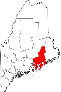 | |
| Towns |
| |
| Unorganized territories | ||
| CDPs | ||
| Other villages |
| |