Hancock, Maine
| Hancock, Maine | |
|---|---|
| Town | |
|
Taunton Bay in 1908 | |
 Hancock, Maine Location within the state of Maine | |
| Coordinates: 44°31′28″N 68°16′59″W / 44.52444°N 68.28306°W | |
| Country | United States |
| State | Maine |
| County | Hancock |
| Incorporated | 1828 |
| Area[1] | |
| • Total | 38.87 sq mi (100.67 km2) |
| • Land | 30.04 sq mi (77.80 km2) |
| • Water | 8.83 sq mi (22.87 km2) |
| Elevation | 95 ft (29 m) |
| Population (2010)[2] | |
| • Total | 2,394 |
| • Estimate (2012[3]) | 2,388 |
| • Density | 79.7/sq mi (30.8/km2) |
| Time zone | Eastern (EST) (UTC-5) |
| • Summer (DST) | EDT (UTC-4) |
| ZIP code | 04640 |
| Area code(s) | 207 |
| FIPS code | 23-30970 |
| GNIS feature ID | 0582509 |
| Website | Town of Hancock, Maine |

Hancock is a town in Hancock County, Maine, United States. The population was 2,394 at the 2010 census. Located on the mainland at the head of Frenchman Bay, Hancock has commanding views of Mount Desert Island.
History
It was first settled in 1766 by Philip and S. Hodgkins from Georgetown.[4] Formed from portions of Sullivan, Trenton and Plantation No. 8, the town was incorporated by the state legislature on February 21, 1828[5] and named for John Hancock, signer of the Declaration of Independence.[6][7] It had two water power sites to operate mills—the Kilkenny and Egypt streams. There was one gristmill, four shingle mills and four lath mills. Other products included staves, lumber, boots, shoes, wagons and sleighs. Many inhabitants were engaged in seafaring, particularly fishing at the Grand Banks.[8]
During World War II, German spies Erich Gimpel and William Colepaugh landed by submarine in Hancock, then traveled to New York City. These spies would eventually be captured, tried, and sentenced to death before their sentences were commuted and they were eventually released.[9]
Geography
According to the United States Census Bureau, the town has a total area of 38.87 square miles (100.67 km2), of which 30.04 square miles (77.80 km2) is land and 8.83 square miles (22.87 km2) is water.[1] Drained by the Kilkenny Stream and Egypt Stream, Hancock is situated on Skillings River, Taunton Bay and Frenchman Bay, part of the Atlantic Ocean.
The town is crossed by U. S. Route 1 and State Route 182. It borders the towns of Lamoine to the south, Ellsworth to the west, T8 SD to the north, Franklin to the east, and (separated by water) is near Sullivan and Sorrento to the southeast.
Demographics
| Historical population | |||
|---|---|---|---|
| Census | Pop. | %± | |
| 1790 | 278 | — | |
| 1830 | 653 | — | |
| 1840 | 760 | 16.4% | |
| 1850 | 960 | 26.3% | |
| 1860 | 923 | −3.9% | |
| 1870 | 974 | 5.5% | |
| 1880 | 1,093 | 12.2% | |
| 1890 | 1,190 | 8.9% | |
| 1900 | 900 | −24.4% | |
| 1910 | 843 | −6.3% | |
| 1920 | 770 | −8.7% | |
| 1930 | 760 | −1.3% | |
| 1940 | 761 | 0.1% | |
| 1950 | 755 | −0.8% | |
| 1960 | 806 | 6.8% | |
| 1970 | 1,070 | 32.8% | |
| 1980 | 1,409 | 31.7% | |
| 1990 | 1,757 | 24.7% | |
| 2000 | 2,147 | 22.2% | |
| 2010 | 2,394 | 11.5% | |
| Est. 2014 | 2,395 | [10] | 0.0% |

2010 census
As of the census[2] of 2010, there were 2,394 people, 1,044 households, and 670 families residing in the town. The population density was 79.7 inhabitants per square mile (30.8/km2). There were 1,437 housing units at an average density of 47.8 per square mile (18.5/km2). The racial makeup of the town was 96.6% White, 0.5% African American, 0.5% Native American, 0.7% Asian, 0.2% from other races, and 1.6% from two or more races. Hispanic or Latino of any race were 1.3% of the population.
There were 1,044 households of which 29.1% had children under the age of 18 living with them, 49.4% were married couples living together, 9.8% had a female householder with no husband present, 5.0% had a male householder with no wife present, and 35.8% were non-families. 28.4% of all households were made up of individuals and 12.6% had someone living alone who was 65 years of age or older. The average household size was 2.28 and the average family size was 2.73.
The median age in the town was 44 years. 20% of residents were under the age of 18; 7.5% were between the ages of 18 and 24; 23.8% were from 25 to 44; 30.8% were from 45 to 64; and 17.8% were 65 years of age or older. The gender makeup of the town was 48.7% male and 51.3% female.
2000 census
As of the census[12] of 2000, there were 2,147 people, 927 households, and 596 families residing in the town. The population density was 72.0 people per square mile (27.8/km²). There were 1,200 housing units at an average density of 40.2 per square mile (15.5/km²). The racial makeup of the town was 97.39% White, 0.33% African American, 0.42% Native American, 0.47% Asian, 0.05% Pacific Islander, 0.14% from other races, and 1.21% from two or more races. Hispanic or Latino of any race were 0.51% of the population.
There were 927 households out of which 30.0% had children under the age of 18 living with them, 50.5% were married couples living together, 9.9% had a female householder with no husband present, and 35.6% were non-families. 27.8% of all households were made up of individuals and 11.7% had someone living alone who was 65 years of age or older. The average household size was 2.31 and the average family size was 2.77.

In the town the population was spread out with 23.6% under the age of 18, 6.1% from 18 to 24, 30.5% from 25 to 44, 23.7% from 45 to 64, and 16.2% who were 65 years of age or older. The median age was 39 years. For every 100 females there were 92.4 males. For every 100 females age 18 and over, there were 91.5 males.
The median income for a household in the town was $32,778, and the median income for a family was $36,855. Males had a median income of $27,448 versus $21,031 for females. The per capita income for the town was $17,339. About 6.9% of families and 9.9% of the population were below the poverty line, including 12.3% of those under age 18 and 8.9% of those age 65 or over.
Education
- The town is home to the Hancock Grammar school.
- The town is also home to the Pierre Monteux School for Conductors and Orchestra Musicians.
Sites of interest
References
- 1 2 "US Gazetteer files 2010". United States Census Bureau. Retrieved 2012-12-16.
- 1 2 "American FactFinder". United States Census Bureau. Retrieved 2012-12-16.
- ↑ "Population Estimates". United States Census Bureau. Retrieved 2013-07-06.
- ↑ Coolidge, Austin J.; John B. Mansfield (1859). A History and Description of New England. Boston, Massachusetts. p. 151.
- ↑ "Hancock, Maine". City-Data.com. Retrieved August 26, 2012.
- ↑ Maine League of Historical Societies and Museums (1970). Doris A. Isaacson, ed. Maine: A Guide 'Down East'. Rockland, Me: Courier-Gazette, Inc. p. 275.
- ↑ "Profile for Hancock Maine, ME". ePodunk. Retrieved August 26, 2012.
- ↑ Varney, George J. (1886), Gazetteer of the state of Maine. Hancock, Boston: Russell
- ↑ http://www.americainwwii.com/articles/nazi-spies-come-ashore/
- ↑ "Annual Estimates of the Resident Population for Incorporated Places: April 1, 2010 to July 1, 2014". Retrieved June 4, 2015.
- ↑ "Census of Population and Housing". Census.gov. Retrieved June 4, 2015.
- ↑ "American FactFinder". United States Census Bureau. Retrieved 2008-01-31.
External links
- Town of Hancock, Maine
- Genealogy Webpage -- Hancock, Maine
- Frenchman Bay Conservancy
- Maine.gov -- Hancock, Maine
- Maine Office of Tourism
| Wikimedia Commons has media related to Hancock, Maine. |
Coordinates: 44°31′45″N 68°15′13″W / 44.52917°N 68.25361°W
Municipalities and communities of Hancock County, Maine, United States | ||
|---|---|---|
| City | 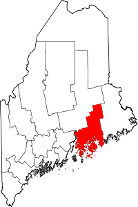 | |
| Towns |
| |
| Unorganized territories | ||
| CDPs | ||
| Other villages |
| |