Johnston County, North Carolina
| Johnston County, North Carolina | ||
|---|---|---|
| County | ||
| County of Johnston | ||
 Johnston County Courthouse in Smithfield | ||
| ||
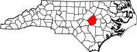 Location in the U.S. state of North Carolina | ||
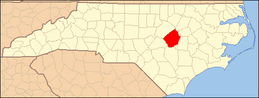
 North Carolina's location in the U.S. | ||
| Founded | June 28, 1746 | |
| Named for | Gabriel Johnston | |
| Seat | Smithfield | |
| Largest town | Clayton | |
| Area | ||
| • Total | 796 sq mi (2,062 km2) | |
| • Land | 791 sq mi (2,049 km2) | |
| • Water | 4.2 sq mi (11 km2), 0.5% | |
| Population (est.) | ||
| • (2014) | 181,423 | |
| • Density | 229.4/sq mi (89/km²) | |
| ZIP code(s) | 27501, 27504, 27520, 27524, 27527, 27529, 27542, 27555, 27557, 27568, 27569, 27576, 27577, 27591, 27592, 27597, 27603, 28334, 28366 | |
| Area code(s) | 919, 984 | |
| Congressional district | 7th | |
| Time zone | Eastern: UTC-5/-4 | |
| Website |
www | |

Johnston County is a county located in the U.S. state of North Carolina. As of the 2010 census, the population was 168,878.[1] Its county seat is Smithfield.[2]
Johnston County is included in the Raleigh, NC Metropolitan Statistical Area, which is also included in the Raleigh-Durham-Chapel Hill, NC Combined Statistical Area, which has a population of 1,998,808 as of U.S. Census 2012 Population Estimates.[3]
History
The county was formed in 1746 from Craven County. It was named for Gabriel Johnston, Governor of North Carolina from 1734 to 1752.[4]
In 1752 parts of Johnston County, Bladen County, and Granville County were combined to form Orange County. In 1758 the eastern part of Johnston County became Dobbs County. In 1770 parts of Johnston County, Cumberland County, and Orange County were combined to form Wake County. Finally, in 1855 parts of Johnston County, Edgecombe County, Nash County, and Wayne County were combined to form Wilson County.
Geography
According to the U.S. Census Bureau, the county has a total area of 796 square miles (2,060 km2), of which 791 square miles (2,050 km2) is land and 4.2 square miles (11 km2) (0.5%) is water.[5]
Adjacent counties
- Nash County (northeast)
- Wilson County (east)
- Wayne County (southeast)
- Sampson County (south)
- Harnett County (southwest)
- Wake County (northwest)
Major highways
Demographics
| Historical population | |||
|---|---|---|---|
| Census | Pop. | %± | |
| 1790 | 5,691 | — | |
| 1800 | 6,301 | 10.7% | |
| 1810 | 6,867 | 9.0% | |
| 1820 | 9,607 | 39.9% | |
| 1830 | 10,938 | 13.9% | |
| 1840 | 10,599 | −3.1% | |
| 1850 | 13,726 | 29.5% | |
| 1860 | 15,656 | 14.1% | |
| 1870 | 16,897 | 7.9% | |
| 1880 | 23,461 | 38.8% | |
| 1890 | 27,239 | 16.1% | |
| 1900 | 32,250 | 18.4% | |
| 1910 | 41,401 | 28.4% | |
| 1920 | 48,998 | 18.3% | |
| 1930 | 57,621 | 17.6% | |
| 1940 | 63,798 | 10.7% | |
| 1950 | 65,906 | 3.3% | |
| 1960 | 62,936 | −4.5% | |
| 1970 | 61,737 | −1.9% | |
| 1980 | 70,599 | 14.4% | |
| 1990 | 81,306 | 15.2% | |
| 2000 | 121,965 | 50.0% | |
| 2010 | 168,878 | 38.5% | |
| Est. 2015 | 185,660 | [6] | 9.9% |
| U.S. Decennial Census[7] 1790-1960[8] 1900-1990[9] 1990-2000[10] 2010-2013[1] | |||
As of the census[11] of 2000, there were 121,965 people, 46,595 households, and 33,688 families residing in the county. The population density was 154 people per square mile (59/km²). There were 50,196 housing units at an average density of 63 per square mile (24/km²). The racial makeup of the county was 78.09% White, 15.65% Black or African American, 0.41% Native American, 0.30% Asian, 0.04% Pacific Islander, 4.53% from other races, and 0.99% from two or more races. 7.74% of the population were Hispanic or Latino of any race.
There were 46,595 households out of which 35.40% had children under the age of 18 living with them, 57.80% were married couples living together, 10.60% had a female householder with no husband present, and 27.70% were non-families. 23.10% of all households were made up of individuals and 8.60% had someone living alone who was 65 years of age or older. The average household size was 2.58 and the average family size was 3.02.
In the county the population was spread out with 26.10% under the age of 18, 8.10% from 18 to 24, 34.20% from 25 to 44, 21.70% from 45 to 64, and 9.80% who were 65 years of age or older. The median age was 34 years. For every 100 females there were 98.70 males. For every 100 females age 18 and over, there were 96.30 males.
The median income for a household in the county was $40,872, and the median income for a family was $48,599. Males had a median income of $33,008 versus $25,582 for females. The per capita income for the county was $18,788. About 8.90% of families and 12.80% of the population were below the poverty line, including 16.00% of those under age 18 and 19.40% of those age 65 or over.
Government
Johnston County is a member of the regional Triangle J Council of Governments.
Johnston County 911 is the first 911 Agency in North Carolina to hold 'Tri Accreditation" from the National Academies of Emergency Dispatch in Fire, Police, and EMD Protocols.
Education
Johnston County is served by the Johnston County School District, which has 44 schools.
Culture
Visitor attractions in Johnston County include several heritage museums and historic sites. The Bentonville Battlefield State Historic Site is located in eastern Johnston County, and it is the largest Civil War Battlefield in North Carolina. The Battle of Bentonville was fought March 19–21, 1865, and was the only Confederate offensive targeted to stop General Sherman's march through the south.
The Tobacco Farm Life Museum in Kenly has been collecting artifacts and showcasing the heritage of the Eastern North Carolina farmer for over 25 years. The site includes a museum and restored farmstead, working blacksmith shop, one-room school house and the site hosts several events each year.
The Ava Gardner Museum located in Smithfield is home to an incredible collection of artifacts such as scripts, movie posters, costumes and personal belongings of screen legend, Ava Gardner, who was born and raised in Johnston County.
The Johnston County Heritage Center is in Downtown Smithfield, and houses artifacts from all over the county. The Heritage Center has become known as one of the best equipped facilities in the country for studying local history and genealogy.
The Johnston County Arts Council promotes arts in the county and its schools.[12] Smithfield is home to an annual Ava Gardner Film Festival (AGFF), which celebrates the life of the actress. In 2008 the festival screened over 40 films in four theaters, including world, regional and state premiers.[13] Rapper Petey Pablo mentions Johnston County in his hit song Raise Up.[14]
The Meadow community is home to Meadow Lights, an annual display of Christmas lights.
Media
Radio
- 102.3
- 99.1
- 97.5
- 92.1
- 105.1
- 101.9
- 95.5
- 98.5
- 94.7
- 93.9
- 101.5
- 102.3
- 99.3
- 100.7
- 96.9
Newspapers
- Clayton News-Star
- Kenly News
- Four Oaks-Benson News in Review
- Princeton News Leader
- The Selma News
- Pine Level News
- Pinceton News Leader
- The Daily Record
- The Smithfield Herald
- The Cleveland Post
- The Garner-Cleveland Record
- The News & Observer
Communities

Towns
- Archer Lodge
- Benson
- Clayton
- Four Oaks
- Kenly
- Micro
- Pine Level
- Princeton
- Selma
- Smithfield (county seat)
- Wilson's Mills
Townships
- Banner
- Bentonville
- Beulah
- Boon Hill
- Brogden
- Clayton
- Cleveland
- Elevation
- Ingrams
- Meadow
- Micro
- O'Neals
- Pine Level
- Pleasant Grove
- Selma
- Smithfield
- Wilders
- Wilson Mills
Unincorporated communities
See also
- List of counties in North Carolina
- National Register of Historic Places listings in Johnston County, North Carolina
References
- 1 2 "State & County QuickFacts". United States Census Bureau. Retrieved October 21, 2013.
- ↑ "Find a County". National Association of Counties. Retrieved 2011-06-07.
- ↑ "Population Estimates 2012 Combined Statistical Areas: April 1, 2010 to July 1, 2012". U.S. Census Bureau. Retrieved 2013-03-14.
- ↑ Gannett, Henry (1905). The Origin of Certain Place Names in the United States (Report) (2nd ed.). Washington: Government Printing Office. p. 170 – via United States Geological Survey.
- ↑ "2010 Census Gazetteer Files". United States Census Bureau. August 22, 2012. Retrieved January 17, 2015.
- ↑ "County Totals Dataset: Population, Population Change and Estimated Components of Population Change: April 1, 2010 to July 1, 2015". Retrieved July 2, 2016.
- ↑ "U.S. Decennial Census". United States Census Bureau. Retrieved January 17, 2015.
- ↑ "Historical Census Browser". University of Virginia Library. Retrieved January 17, 2015.
- ↑ Forstall, Richard L., ed. (March 27, 1995). "Population of Counties by Decennial Census: 1900 to 1990". United States Census Bureau. Retrieved January 17, 2015.
- ↑ "Census 2000 PHC-T-4. Ranking Tables for Counties: 1990 and 2000" (PDF). United States Census Bureau. April 2, 2001. Retrieved January 17, 2015.
- ↑ "American FactFinder". United States Census Bureau. Retrieved 2008-01-31.
- ↑ "Johnston County Arts Council". Retrieved 2008-01-13.
- ↑ "Ava Gardner Festival". Retrieved 2008-01-13.
- ↑ Petey Pablo Raise Up lyrics on Yahoo! Music
Further reading
- Johnston County, North Carolina, Court Martial Minutes, 1761-1779. Transcribed by Weynette Parks Haun (1st ed.). 1983. LCCN 83-244254.
- Marriages of Johnston County, North Carolina, 1762-1868. Compiled by Brent H. Holcomb. Baltimore: Genealogical Publishing Co. 1985. ISBN 0-8063-1120-7. LCCN 85-70012.
- Sanders, Jr., W. M.; Ragsdale, G. Y. (1922). Johnston County: Economic and Social. University of North Carolina. LCCN 39014760. OCLC 6523398 – via The Smithfield Observer.
External links
| Wikimedia Commons has media related to Johnston County, North Carolina. |
- Official website
- Johnston County Heritage Center, with historical photos, online tours and exhibits, timelines, and facts
- Johnston County Visitors Bureau, the official site for visitor information for Johnston County
 |
Wake County | Nash County | | |
| |
Wilson County | |||
| ||||
| | ||||
| Harnett County | Sampson County | Wayne County |
Coordinates: 35°31′N 78°22′W / 35.52°N 78.37°W