Greene County, North Carolina
- Greenville, NC has no relation to Greene County, NC. For the neighboring county that Greenville is in, see Pitt County, North Carolina.
| Greene County, North Carolina | |
|---|---|
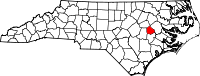 Location in the U.S. state of North Carolina | |
 North Carolina's location in the U.S. | |
| Founded | 1791 |
| Named for | Nathanael Greene |
| Seat | Snow Hill |
| Largest town | Snow Hill |
| Area | |
| • Total | 266 sq mi (689 km2) |
| • Land | 266 sq mi (689 km2) |
| • Water | 0.5 sq mi (1 km2), 0.2% |
| Population | |
| • (2010) | 21,362 |
| • Density | 80/sq mi (31/km²) |
| Congressional districts | 1st, 3rd |
| Time zone | Eastern: UTC-5/-4 |
| Website |
www |
Greene County is a county located in the U.S. state of North Carolina. As of the 2010 census, the population was 21,362.[1] Its county seat is Snow Hill.[2]
History
Greene County, being a part of land grant by King Charles II of England in 1663, was first settled around 1710 by immigrants from Maryland, Virginia, and parts of North Carolina. The original inhabitants of the area, the Tuscarora Indians, fought with these immigrants and on March 20–23, 1713, a fighting force of South Carolinians and Yemassce Indians, under Colonel Murice Moore, defeated the Tuscarora, under the leadership of Chief Hancock. This was the final major battle of the Tuscarora War at Fort Neoheroka near current day Snow Hill.
In 1758, the area now recognized as Greene and Lenoir Counties was separated from Johnston and named Dobbs for the Royal Governor. The county was formed in 1791 from the northern part of Dobbs County. It was originally named Glasgow County, for James Glasgow, North Carolina Secretary of State from 1777 to 1798. In 1799, Glasgow's involvement in military land grant frauds forced him to resign and leave the state. Glasgow County was then renamed Greene County in honor of Nathanael Greene, one of General Washington's right-hand men.
The county seat, Snow Hill, is the largest town and major commercial center in the county. The town draws its name from the historic white sandy banks of nearby Contentnea Creek.[3]
Law and government
Greene County is a member of the regional Eastern Carolina Council of Governments.
Geography
According to the U.S. Census Bureau, the county has a total area of 266 square miles (690 km2), of which 266 square miles (690 km2) is land and 0.5 square miles (1.3 km2) (0.2%) is water.[4]
Adjacent counties
- Pitt County – northeast
- Lenoir County – south
- Wayne County – west
- Wilson County – northwest
Demographics
| Historical population | |||
|---|---|---|---|
| Census | Pop. | %± | |
| 1800 | 4,218 | — | |
| 1810 | 4,867 | 15.4% | |
| 1820 | 4,533 | −6.9% | |
| 1830 | 6,413 | 41.5% | |
| 1840 | 6,595 | 2.8% | |
| 1850 | 6,619 | 0.4% | |
| 1860 | 7,925 | 19.7% | |
| 1870 | 8,687 | 9.6% | |
| 1880 | 10,037 | 15.5% | |
| 1890 | 10,039 | 0.0% | |
| 1900 | 12,038 | 19.9% | |
| 1910 | 13,083 | 8.7% | |
| 1920 | 16,212 | 23.9% | |
| 1930 | 18,656 | 15.1% | |
| 1940 | 18,548 | −0.6% | |
| 1950 | 18,024 | −2.8% | |
| 1960 | 16,741 | −7.1% | |
| 1970 | 14,967 | −10.6% | |
| 1980 | 16,117 | 7.7% | |
| 1990 | 15,384 | −4.5% | |
| 2000 | 18,974 | 23.3% | |
| 2010 | 21,362 | 12.6% | |
| Est. 2015 | 21,134 | [5] | −1.1% |
| U.S. Decennial Census[6] 1790-1960[7] 1900-1990[8] 1990-2000[9] 2010-2013[1] | |||
As of the census[10] of 2000, there were 18,975 people, 6,696 households, and 4,955 families residing in the county. The population density was 72 people per square mile (28/km²). There were 7,368 housing units at an average density of 28 per square mile (11/km²). The racial makeup of the county was 51.83% White, 41.21% Black or African American, 0.30% Native American, 0.09% Asian, 0.01% Pacific Islander, 5.75% from other races, and 0.80% from two or more races. 7.96% of the population were Hispanic or Latino of any race.
There were 6,696 households out of which 34.30% had children under the age of 18 living with them, 52.10% were married couples living together, 17.30% had a female householder with no husband present, and 26.00% were non-families. 22.60% of all households were made up of individuals and 10.00% had someone living alone who was 65 years of age or older. The average household size was 2.65 and the average family size was 3.09.
In the county the population was spread out with 25.30% under the age of 18, 9.40% from 18 to 24, 30.90% from 25 to 44, 22.30% from 45 to 64, and 12.10% who were 65 years of age or older. The median age was 36 years. For every 100 females there were 105.70 males. For every 100 females age 18 and over, there were 103.90 males.
The median income for a household in the county was $32,074, and the median income for a family was $36,419. Males had a median income of $27,048 versus $21,351 for females. The per capita income for the county was $15,452. About 16.00% of families and 20.20% of the population were below the poverty line, including 28.30% of those under age 18 and 20.50% of those age 65 or over.
Education
Schools is Greene County are administered by the Greene County Public School system. The five schools include Greene Central High School, Greene Early College High School, Greene County Middle School, Snow Hill Primary School and West Greene Elementary School.[11] Higher education is provided through nearby East Carolina University or community colleges located in Goldsboro, Greenville and Kinston. One private school, Mt. Calvary Christian Academy, is also located in the county.
Transportation
Major highways
The major highways that run through the county are US 264 and US 13. Other highways include US 258, NC 903, NC58, NC 102 and NC 91. The closest interstate is I-795, located west of the county in Goldsboro.
Airport
The closest airport to Greene County is Pitt-Greenville Airport (IATA: PGV, ICAO: KPGV, FAA LID: PGV) with service to Charlotte Douglas International Airport, although most residents use Raleigh-Durham International Airport for domestic and international travel.
Communities
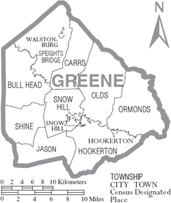
Towns
- Farmville
- Hookerton
- Snow Hill (county seat)
- Walstonburg
Census-designated place
Unincorporated community
Townships
- Bull Head
- Carrs
- Hookerton
- Jason
- Olds
- Ormondsville
- Shine
- Snow Hill
- Speights Bridge
See also
References
- 1 2 "State & County QuickFacts". United States Census Bureau. Retrieved October 19, 2013.
- ↑ "Find a County". National Association of Counties. Retrieved 2011-06-07.
- ↑ Greene County – History
- ↑ "2010 Census Gazetteer Files". United States Census Bureau. August 22, 2012. Retrieved January 17, 2015.
- ↑ "County Totals Dataset: Population, Population Change and Estimated Components of Population Change: April 1, 2010 to July 1, 2015". Retrieved July 2, 2016.
- ↑ "U.S. Decennial Census". United States Census Bureau. Retrieved January 17, 2015.
- ↑ "Historical Census Browser". University of Virginia Library. Retrieved January 17, 2015.
- ↑ Forstall, Richard L., ed. (March 27, 1995). "Population of Counties by Decennial Census: 1900 to 1990". United States Census Bureau. Retrieved January 17, 2015.
- ↑ "Census 2000 PHC-T-4. Ranking Tables for Counties: 1990 and 2000" (PDF). United States Census Bureau. April 2, 2001. Retrieved January 17, 2015.
- ↑ "American FactFinder". United States Census Bureau. Retrieved 2008-01-31.
- ↑ Greene County Schools
External links
- Greene County, NC Chamber of Commerce
- Greene County government official website
- Snow Hill, NC – County Seat of Greene County, NC
- Contentnea Development Partnership, Non Profit Economic Development Agency Serving Greene County NC
 |
Wilson County | Pitt County | | |
| Wayne County | |
|||
| ||||
| | ||||
| Lenoir County |
Municipalities and communities of Greene County, North Carolina, United States | ||
|---|---|---|
| Towns | 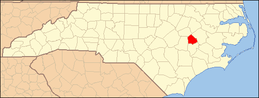 | |
| CDP | ||
| Unincorporated community | ||
Coordinates: 35°29′N 77°41′W / 35.49°N 77.68°W