Interstate 495 (North Carolina)
| ||||
|---|---|---|---|---|
 | ||||
| Route information | ||||
| Maintained by NCDOT | ||||
| Length: | 4.09 mi[1][2] (6.58 km) | |||
| Existed: | 2013 – present | |||
| Major junctions | ||||
| South end: |
| |||
| North end: |
| |||
| Location | ||||
| Counties: | Wake | |||
| Highway system | ||||
| ||||
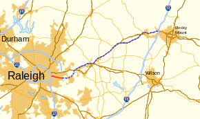
Interstate 495 (I-495) is a designated, auxiliary Interstate Highway in the U.S. state of North Carolina. It serves as a connector between I-440 and I-540 in Wake County; when completed, it will also connect with I-95, in Rocky Mount. It is also part of the Future Interstate 87 corridor.
Route description
I-495 is a six-lane connector interstate highway that connects I-440, in Raleigh, and I-540, in Knightdale; it is entirely concurrent with US 64/US 264. Speed limit for majority of the route is 70 miles per hour (110 km/h). Mileage markers and exit numbers along route are from US 64.
History


I-495 first appeared on February 20, 2013, when the North Carolina Department of Transportation submitted a request to AASHTO in order to establish Interstate 495 as a new auxiliary route of I-95. The proposed 44.99-mile (72.40 km) route would begin at I-440/US 64/US 64 Business in Raleigh and would end at I-95, in Rocky Mount, completely concurrent with US 64.[3]
On March 15, 2013, AASHTO received a modified request from NCDOT requesting the establishment of I-495 from I-440 to I-540 (4.09 mi or 6.58 km) and Future I-495 from I-540 to I-95 (40.90 mi or 65.82 km). In the official request, it also requested a waiver to not renumber I-540 because it would be connecting to another interstate and the reason for the future designation is because that section will require improvement to pavement, shoulders, and in one spot roadway width (near Nashville). It was approved, though needed an additional approval from FHWA.[2] On December 12, 2013, it was announced by Governor Pat McCrory and Transportation Secretary Tony Tata that the proposed section was approved by the FHWA and was added to the interstate highway system. I-495 will exist as described by its application to AASHTO, with a Future I-495 signed to I-95.[4]
The freeway section, the part that is to be signed I-495 and continuing east to US 64 Business, was completed in 2006. From I-440 to Rolesville Road, the freeway was built to interstate standards; which is why the first official section of I-495 was able to connect between I-440 and I-540.[5] East of Rolesville Road, the freeway was built over the years to state freeway standards, since 1975. This older section of freeway will eventually be upgraded to interstate standards; which include road rehabilitation and wider lanes and shoulders.
Future Interstate 87
| |
|---|---|
| Location: | Raleigh, NC – VA state line |
| Length: | 179 mi (288 km) |
I-495 is slated to continue east along US 64 to I-95, once road improvements are completed upgrading it to interstate standards. Currently, this section is signed as Future I-495.[2][4]
Long-term plans by the Raleigh-Durham area's Regional Transportation Alliance (RTA) called for extension of the interstate east of I-95 toward Elizabeth City, then northeastward to the Interstate 64/Interstate 464 interchange in the Norfolk-Virginia Beach (Hampton Roads) metropolitan area. RTA's plan envisions the entirety of the corridor from Raleigh to Norfolk receiving a new two-digit interstate designation. This interstate would connect two of the United States' largest metropolitan areas still lacking direct interstate access between each other. Potential route numbers for this corridor included I-44 and I-50.[6][7] On December 14, 2015, the proposed corridor was officially designated as a future interstate with the passing of the Fixing America's Surface Transportation Act (FAST Act)[8] Soon, several other route numbers were discussed and the RTA set their preference on two more-likely candidates: Interstate 56 if an east-west designation were chosen, or Interstate 89 if a north-south designation were chosen.[9] After review of the RTA's recommendation and others, NCDOT proposed I-89 as the new route number for the corridor and submitted it to the AASHTO Special Committee on U.S. Route Numbering.[10] On May 24, 2016, AASHTO instead approved Interstate 87 as the designation for the route.[11][12] This duplicates an already-existing number used on a highway that is located entirely in the state of New York; however, the routing is planned as an intentional gap: the first going north-south. The Interstate 87 designation pays tribute to several important dates in the history of both North Carolina and Virginia. In 1587 the Roanoke Colony was founded, in 1787 James Madison's Virginia Plan helped to develop U.S. Constitution, and North Carolina State University was created in 1887.[13]
Junction list
| County | Location | mi[1] | km | Exit | Destinations | Notes |
|---|---|---|---|---|---|---|
| Wake | Raleigh | 0.0 | 0.0 | 419 | West end of US 64 overlap and western terminus of US 264 Southern terminus of I-495 | |
| 0.9 | 1.4 | 420 | New Hope Road | |||
| Knightdale | 3.1 | 5.0 | 422 | Hodge Road | ||
| 4.1 | 6.6 | 423 | East end of US 64/US 264 overlap North end of I-495 and south end of Future I-495 | |||
| | 425 | Smithfield Road | Built to interstate standards, signed future[2] | |||
| Wendell | 427 | Taylor Road/Wendell Falls Parkway | ||||
| 429 | ||||||
| 430 | Rolesville Road – Rolesville | |||||
| | 432 | Lizard Lick Road – Wendell | Upgrade to interstate standards[2] | |||
| Zebulon | 435 | |||||
| 436 | ||||||
| Franklin | | 439 | ||||
| | 442 | SR 1737 (Tant Road) | ||||
| Nash | | |||||
| | ||||||
| | Old Franklin Road – Momeyer | |||||
| Nashville | 458 | |||||
| 459 | ||||||
| 461 | ||||||
| | 463 | Old Carriage Road – Red Oak | ||||
| Rocky Mount | 464 | Upgrade to interstate standards[2] Northern terminus of Future I-495 | ||||
1.000 mi = 1.609 km; 1.000 km = 0.621 mi
| ||||||
See also
-
 North Carolina portal
 -
 U.S. Roads portal
References
- 1 2 Google (December 14, 2013). "Interstate 495" (Map). Google Maps. Google. Retrieved December 14, 2013.
- 1 2 3 4 5 6 "Binder-all applications May 2013" (PDF). American Association of State Highway and Transportation Officials. May 2013. p. 56. Retrieved December 14, 2013.
- ↑ I-495 Route Change (2013-02-20) (PDF) (Map). North Carolina Department of Transportation. December 14, 2013. Retrieved February 28, 2013.
- 1 2 "North Carolina Gets a New Interstate, with the I-495 Designation near Raleigh" (Press release). Raleigh, NC: North Carolina Department of Transportation. December 14, 2013. Retrieved December 12, 2013.
- ↑ "US 64 Route Change (2006-11-08)" (PDF). North Carolina Department of Transportation. November 8, 2006. Retrieved December 14, 2013.
- ↑ "Interstate 495 to Rocky Mount—Future I-44 to Hampton Roads". Raleigh, NC: Regional Transportation Alliance. December 14, 2013. Retrieved February 16, 2014.
- ↑ Gibson, Terry R. (November 27, 2012). "Designation of I-44" (PDF) (Letter). Letter to John F. Sullivan III. Raleigh, NC: North Carolina Department of Transportation. Retrieved May 15, 2014.
- ↑ "H. R. 22—111" (PDF). Retrieved March 31, 2016.
- ↑ "Raleigh-Norfolk: I-495, I-44, I-50, I-89, I-56 … ?". Raleigh, NC: Regional Transportation Alliance. December 31, 2015. Retrieved February 1, 2016.
- ↑ "AASHTO Electronic Balloting System - View Ballot - Agenda and List of Applicatons SM-2016" (PDF). AASHTO. Retrieved May 5, 2016.
- ↑ "North Carolina Gains Names for Two New Interstate Designations" (Press release). Raleigh, NC: North Carolina Department of Transportation. May 25, 2016. Retrieved May 25, 2016.
- ↑ Vitale, Marty (May 24, 2016). "Special Committee on U.S. Route Numbering" (PDF) (Report). Des Moines, IA: American Association of State Highway and Transportation Officials. p. 8. Retrieved May 26, 2016.
- ↑ WRAL (2016-05-26). "North Carolina gets designations for 2 more interstates :: WRAL.com". WRAL.com. Retrieved 2016-12-02.
External links
-
 Media related to Interstate 495 (North Carolina) at Wikimedia Commons
 - Media related to Interstate 87 in North Carolina at Wikimedia Commons
- Interstate-Guide: Interstate 495 North Carolina
- I-495 Connecting I-95 to Raleigh
| ||