Indiana State Road 49
| ||||
|---|---|---|---|---|
 | ||||
| Route information | ||||
| Maintained by INDOT | ||||
| Length: | 44.15 mi[1] (71.05 km) | |||
| Existed: | October 1, 1926[2] – present | |||
| Major junctions | ||||
| South end: |
| |||
|
| ||||
| North end: |
| |||
| Highway system | ||||
| ||||

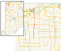
State Road 49 (SR 49) in the U.S. State of Indiana is a state highway in northwest Indiana. It runs from just north of Chesterton, at the intersection with U.S. Route 12 (Dunes Highway) south, to a rural interchange, 10 miles (16 km) northeast of Rensselaer, with State Road 14. This is a distance of about 44.15 miles (71.05 km).
Route description
The southern terminus of SR 49 is in Wheatfield at State Road 14 (SR 14). SR 49 heads north from Wheatfield toward Valparaiso, just south of Valparaiso SR 49 becomes a four-lane divided highway. Then in Valparaiso SR 49 has an interchange with U.S. Route 30 (US 30). After the US 30 interchange, SR 49 and State Road 2 have an interchange. Then SR 49 leaves Valparaiso heading north toward Chesterton having an interchange with U.S. Route 6, Interstate 80/Interstate 90/Indiana Toll Road, Interstate 94, U.S. Route 20, and U.S. Route 12. US 12 is the northern terminus of SR 49.[3]
History
Before 1926, SR 49 was a named Liberty Way from Kouts to Valparaiso, it was a named state route. After 1926, SR 49 was a two-lane highway from Valparaiso to Chesterton, known as "Old State Road 49". When the Valparaiso Bypass was completed the old route was decommissioned and turned over to the City of Valparaiso, the City of Chesterton, and Porter County.
Major intersections
| County | Location | mi[1] | km | Destinations | Notes |
|---|---|---|---|---|---|
| Jasper | Barkley Township | 0.00 | 0.00 | Southern terminus of SR 49 | |
| Wheatfield | 10.99 | 17.69 | |||
| Porter | Kouts | 20.40 | 32.83 | ||
| Valparaiso | 29.73 | 47.85 | Southern end of SR 2 concurrency | ||
| 30.83 | 49.62 | Northern end of SR 2 concurrency | |||
| Liberty Township | 36.73 | 59.11 | Underpass | ||
| 38.35 | 61.72 | Overpass | |||
| Chesterton | 41.70– 41.99 | 67.11– 67.58 | Overpass | ||
| Porter | 42.76– 42.77 | 68.82– 68.83 | |||
| 44.15 | 71.05 | Northern terminus of SR 49; US 12 west to steel mills | |||
1.000 mi = 1.609 km; 1.000 km = 0.621 mi
| |||||
See also
References
- 1 2 "INDOT Roadway Referencing System" (PDF). Archived from the original (PDF) on June 15, 2011.
- ↑ "Road Numbers to Be Changed". The Hancock-Democrat. The Indianapolis News. September 30, 1926. Retrieved June 9, 2016 – via Newspapers.com.

- ↑ Yahoo!; Navteq (2011-01-10). "overview map of SR 49" (Map). Yahoo! Maps. Yahoo!. Retrieved 2011-01-10.