Imphal
| Imphal City ইম্ফল | |
|---|---|
| Capital city of Manipur | |
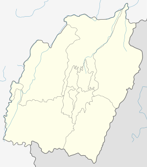 Imphal City  Imphal City Location of Imphal in Manipur | |
| Coordinates: 24°49′N 93°57′E / 24.82°N 93.95°ECoordinates: 24°49′N 93°57′E / 24.82°N 93.95°E | |
| Country | India |
| State | Manipur |
| District | Imphal West, Imphal East |
| Elevation | 786 m (2,579 ft) |
| Population (2011 census) | |
| • Total | 264,986 (City), 414,288 (Metropolitan area)[1] |
| Languages | |
| • Official | Meiteilon (Manipuri) |
| Time zone | IST (UTC+5:30) |
| PIN | 795001 |
| Telephone code | 3852 |
| Vehicle registration | MN01 |
| Website |
www |
The city of Imphal (/ˈɪmpəl/, ![]() Imphal.ogg ) is the capital of the Indian state of Manipur. The ruins of the Palace of Kangla, the royal seat of the erstwhile Kingdom of Manipur, are in the city centre, surrounded by a moat.
Imphal.ogg ) is the capital of the Indian state of Manipur. The ruins of the Palace of Kangla, the royal seat of the erstwhile Kingdom of Manipur, are in the city centre, surrounded by a moat.
History
The Battle of Imphal took place between March and July 1944, during World War II.[2]
Geography and climate
| Imphal | ||||||||||||||||||||||||||||||||||||||||||||||||||||||||||||
|---|---|---|---|---|---|---|---|---|---|---|---|---|---|---|---|---|---|---|---|---|---|---|---|---|---|---|---|---|---|---|---|---|---|---|---|---|---|---|---|---|---|---|---|---|---|---|---|---|---|---|---|---|---|---|---|---|---|---|---|---|
| Climate chart (explanation) | ||||||||||||||||||||||||||||||||||||||||||||||||||||||||||||
| ||||||||||||||||||||||||||||||||||||||||||||||||||||||||||||
| ||||||||||||||||||||||||||||||||||||||||||||||||||||||||||||
Imphal is located at 24°49′N 93°57′E / 24.82°N 93.95°E in extreme eastern India,[4] with an average elevation of 786 metres (2,579 ft). It has a humid subtropical climate (Köppen Cwa)[5] with mild, dry winters and a hot monsoon season. July temperatures average about 29 °C (84 °F); January is the coldest month, with average lows near 4 °C (39 °F). The city receives about 1,320 mm (52 in) of rain, with June the wettest month. The highest recorded temperature was 35.6 °C (96.1 °F), most recently on 22 May 2009, and the lowest average temperature was −2.7 °C (27.1 °F) on 10 January 1970.[3][6]
| Climate data for Imphal | |||||||||||||
|---|---|---|---|---|---|---|---|---|---|---|---|---|---|
| Month | Jan | Feb | Mar | Apr | May | Jun | Jul | Aug | Sep | Oct | Nov | Dec | Year |
| Record high °C (°F) | 27.8 (82) |
31.5 (88.7) |
35.0 (95) |
34.4 (93.9) |
35.6 (96.1) |
35.6 (96.1) |
35.7 (96.3) |
34.0 (93.2) |
34.4 (93.9) |
33.5 (92.3) |
30.7 (87.3) |
28.9 (84) |
35.7 (96.3) |
| Average high °C (°F) | 21.7 (71.1) |
23.4 (74.1) |
26.9 (80.4) |
28.4 (83.1) |
28.9 (84) |
29.4 (84.9) |
29.0 (84.2) |
29.2 (84.6) |
29.0 (84.2) |
28.4 (83.1) |
25.4 (77.7) |
22.4 (72.3) |
26.9 (80.4) |
| Daily mean °C (°F) | 14.5 (58.1) |
16.3 (61.3) |
20.0 (68) |
22.7 (72.9) |
24.1 (75.4) |
24.6 (76.3) |
24.5 (76.1) |
24.6 (76.3) |
24.4 (75.9) |
22.8 (73) |
19.0 (66.2) |
15.6 (60.1) |
21.1 (70) |
| Average low °C (°F) | 4.3 (39.7) |
7.2 (45) |
11.6 (52.9) |
15.7 (60.3) |
18.4 (65.1) |
21.2 (70.2) |
21.5 (70.7) |
21.3 (70.3) |
20.1 (68.2) |
16.6 (61.9) |
11.0 (51.8) |
5.3 (41.5) |
14.6 (58.3) |
| Record low °C (°F) | −2.7 (27.1) |
−1.4 (29.5) |
2.4 (36.3) |
6.2 (43.2) |
11.1 (52) |
14.7 (58.5) |
15.4 (59.7) |
14.6 (58.3) |
14.3 (57.7) |
7.8 (46) |
1.5 (34.7) |
−1.7 (28.9) |
−2.7 (27.1) |
| Average precipitation mm (inches) | 11.7 (0.461) |
30.8 (1.213) |
91.6 (3.606) |
132.7 (5.224) |
158.6 (6.244) |
224.9 (8.854) |
222.8 (8.772) |
194.8 (7.669) |
147.3 (5.799) |
111.5 (4.39) |
46.0 (1.811) |
15.1 (0.594) |
1,387.7 (54.634) |
| Average precipitation days | 1.2 | 3.3 | 6.6 | 9.8 | 11.5 | 15.3 | 15.7 | 13.0 | 9.9 | 6.8 | 3.1 | 1.0 | 97.2 |
| Source #1: IMD (period: 1971–2000, record low and high up to 2010)[3][6] | |||||||||||||
| Source #2: Climate-Data.org for mean temperatures (altitude: 779m)[5] | |||||||||||||
Landmarks of Imphal
Kangla
.jpeg) Bamboo huts in Kangla Fort complex
Bamboo huts in Kangla Fort complex.jpeg) Entrance to complex
Entrance to complex Kangla Fort Complex
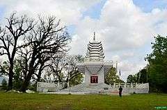 Ibudhou Pakhangba Temple
.jpeg) Ruins of Kangla Fort
Ruins of Kangla Fort.jpeg) Kangla Museum houses
Kangla Museum houses.jpeg) Manung Thangapat Pond
Manung Thangapat Pond.jpeg) Shri Govindajee Temple
Shri Govindajee Temple
Kangla Fort is on the banks of the Imphal River, and is also known as the Palace of Kangla. Kangla means "dry land" in the Meitei language. The fort was the palace of King Pakhangba, and also has religious significance. In the fort are a number of temples, and it is surrounded on three sides by a lake.
Hiyangthang Lairembi Temple Complex
A religious site and a tourist attraction, the temple complex is noted for its annual Durga Puja festival in September or October.
Shree Govindajee Temple
The temple was considered the apex of cultural activity during the reign of the Maharajas. Near the palace, it has two domes and a raised congregation hall.
Imphal War Cemetery
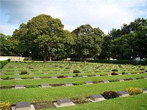
This cemetery remembers British and Indian soldiers who fought and died in the Second World War (1944).
Women's Market (Ima Keithel)
The market stalls are all run by women, and it is reportedly the only such market in the world.[7]
.jpeg)
Transport
Air
.jpeg)
.jpeg)
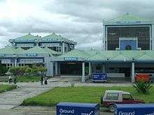
Imphal International Airport is 8 kilometres (5.0 mi) south of the city.[8]
Rail
In October 2012, India's Cabinet Committee on Infrastructure approved an extension of the Jiribam-Silchar railway to Imphal. The extension is expected to reach the city by March 2016.[9]
Demographics
The Imphal metropolitan area is made up of Bijoy Govinda, Chingangbam Leikai, Imphal, Khongman, Khurai Sajor Leikai, Kiyamgei, Kongkham Leikai (portion), Laipham Siphai, Lairikyengbam Leikai, Lamjaotongba, Lamshang (core town), Langjing, Langthabal Kunja, Langthabal Mantrikhong (portion), Lilong (Imphal West) (core town), Lilong (Thoubal), Naorem Leikai, Naoria Pakhanglakpa, Oinam Thingel, Porompat, Porompat Plan Area, Sagolband (portion), Takyel Mapal, Thongju and Torban (Kshetri Leikai).[1]
Education
Universities
Technical colleges
Medical colleges
- Regional Institute of Medical Sciences[12]
- Jawaharlal Nehru Institute of Medical Science[13]

References
- 1 2 Census2011.co.in. 2011. Retrieved 2011-09-30.
- ↑ "Imphal and Kohima". Britain's Greatest Battles. National Army Museum. Retrieved 9 January 2016.
- 1 2 3 "Imphal, India". India Meteorological Department. Retrieved 16 May 2014.
- ↑ "Maps, Weather, and Airports for Imphal, India". Retrieved 10 June 2015.
- 1 2 "Climate: Imphal - Climate graph, Temperature graph, Climate table". Climate-Data.org. Retrieved 31 October 2013.
- 1 2 "Ever recorded Maximum and minimum temperatures upto 2010". India Meteorological Department. Archived from the original on 21 May 2013. Retrieved 16 May 2014.
- ↑ "Ima Keithel – A market by women". She. msn. Retrieved 25 November 2012.
- ↑ "Imphal". Airports Authority of India. Retrieved 25 November 2012.
- ↑ "Govt approves rail link to Imphal". The Indian Express. 26 October 2012. Retrieved 25 November 2012.
- ↑ "Manipur University". Retrieved 10 June 2015.
- ↑ "Welcome To NIT Manipur". Retrieved 10 June 2015.
- ↑ "Regional Institute of Medical Sciences". Retrieved 28 January 2014.
- ↑ "JNIMS". Retrieved 28 January 2014.
External links
 Imphal travel guide from Wikivoyage
- Imphal West
- Imphal East
| Wikimedia Commons has media related to Imphal. |