Kavaratti
| Native name: <span class="nickname" ">കവരത്തി | |
|---|---|
 Kavaratti | |
| Geography | |
| Location | Arabian Sea |
| Coordinates | 10°34′N 72°38′E / 10.57°N 72.64°ECoordinates: 10°34′N 72°38′E / 10.57°N 72.64°E |
| Archipelago | Lakshadweep |
| Adjacent bodies of water | Indian Ocean |
| Total islands | 1 |
| Major islands |
|
| Area | 3.93 km2 (1.52 sq mi)[1] |
| Length | 5 km (3.1 mi) |
| Width | 1.5 km (0.93 mi) |
| Highest elevation | 1 m (3 ft) |
| Administration | |
| Territory | Union territory of Lakshadweep |
| District | Lakshadweep |
| Island group | Laccadive Islands |
| Tehsils of India | Kavaratti |
| Subdivisions of India | Kavaratti |
| Demographics | |
| Demonym | Malayali |
| Population | 11473 (2014) |
| Pop. density | 2,920 /km2 (7,560 /sq mi) |
| Ethnic groups | Malayali, Mahls |
| Additional information | |
| Time zone | |
| PIN | 682555 |
| Telephone code | 04896 |
| Official website |
lakshadweep |
| ISO Code | IN-LD-05[2] |
| Literacy | 88.6% |
| Avg. summer temperature | 35 °C (95 °F) |
| Avg. winter temperature | 25 °C (77 °F) |
| Sex ratio | 1.227 ♂/♀ |
| unit_pref | Metric |
Kavaratti (Malayalam: കവരത്തി) is the capital of the Union Territory of Lakshadweep in India. Kavaratti is a census town as well as the name of the atoll upon which the town stands. It is well known for its pristine white sand beaches and calm lagoons, which makes it a popular tourist destination. It has a distance of 2,056 km (1,278 mi) south of the city of Delhi.
History
Kavaratti has been selected as one of the hundred Indian cities to be developed as a smart city under the Smart Cities Mission. [3]
Geography
The island of Kavaratti lies 360 km (190 nmi) off the coast of the state of Kerala at 10°34′N 72°38′E / 10.57°N 72.64°E.[4] It has an average elevation of 0 metres (0 feet).
The closest island is uninhabited Pitti islet, located 24 km (13 nmi) north of Kavaratti. The inhabited island of Agatti lies 54 km to the NW and Suheli Par 53 km to the SW.
Kochi is the closest major city on the Indian mainland at a distance of 404 km (218 nmi). It has a lagoon area of 8.96 km2 (3.46 sq mi).
Climate
Kavaratti has a tropical monsoon climate. March to May is the hottest period of the year. The year-round temperature ranges between 25-35 °C. Humidity range is 70-76%.[5]
The monsoon rains usually start at the end of May and continue through early September. The island receives an average of 1600mm of rain during the year.
| Climate data for Kavaratti | |||||||||||||
|---|---|---|---|---|---|---|---|---|---|---|---|---|---|
| Month | Jan | Feb | Mar | Apr | May | Jun | Jul | Aug | Sep | Oct | Nov | Dec | Year |
| Average high °C (°F) | 30.2 (86.4) |
30.4 (86.7) |
31.1 (88) |
31.8 (89.2) |
31.3 (88.3) |
30.4 (86.7) |
29.8 (85.6) |
29.7 (85.5) |
29.8 (85.6) |
30 (86) |
30.3 (86.5) |
30.3 (86.5) |
30.4 (86.7) |
| Average low °C (°F) | 22.7 (72.9) |
23.1 (73.6) |
24.3 (75.7) |
25.5 (77.9) |
25.8 (78.4) |
25 (77) |
24.6 (76.3) |
24.7 (76.5) |
24.6 (76.3) |
24.3 (75.7) |
23.6 (74.5) |
23.2 (73.8) |
24.3 (75.7) |
| Average precipitation mm (inches) | 27.4 (1.079) |
25.4 (1) |
19.8 (0.78) |
72.5 (2.854) |
212.8 (8.378) |
261.3 (10.287) |
250.9 (9.878) |
202.4 (7.969) |
181.9 (7.161) |
183.1 (7.209) |
133.0 (5.236) |
94.8 (3.732) |
1,674.9 (65.941) |
Demographics
The 2011 population for Kavaratti was 11,210 based on the 2011 census of India.[6] Males constitute 55% of the population and females 45%. Of the 1797 families on the island, 57 (about 3%) are below the poverty line.
The literacy was 88.6% for Kavaratti. This was an increase from 44.4% in 1971. The male literacy rate was 94.1%, while the female literacy was 81.66%.[6] In Kavaratti, 12% of the population is under 6 years of age.
The most commonly spoken languages are Malayalam, Mahl and English.[7]
Administration
The island belongs to the township of Kavaratti Island of Kavaratti Tehsil.[8]
Economy
Tourism is one of the primary industries on the island. The island has pristine white sand beaches, favored by tourists for sun bathing. The calm lagoons on Kavaratti island are ideal for water sports and swimming.[9]
A number of hotels and resorts have been developed on Kavaratti in recent years. The waters around the coral atoll are rich in diverse marine life. The Kavaratti Aquarium has a rich collection of corals and a vast collection of tropical fish specimens.
The other major industries on the island are fisheries and agriculture. Coconut is the dominant crop on the island. With the ascent of tourism, the fishing industry has seen a major decline.
Transportation
Among the most popular means of travel to Kavaratti from the Indian mainland is via an overnight voyage by passenger ships. A number of passenger liners operate from Kochi to Kavaratti and other Lakshadweep islands.
The nearest domestic airport is on Agatti Island 54 km (29 nmi) away, followed by helicopter or boat transfers from Agatti to Kavaratti.[6] Commercial flights usually operate from Kochi to Agatti.
The closest international airport is the Cochin International Airport in Kochi on the mainland.
Education
There are 2 primary schools and 2 secondary schools on the island. In addition there were 14 anganwadis.
Healthcare
Kavaratti hosts a co-operative hospital. There is also a Krishibhavan and an associated veterinary hospital on the island.[6]
Water supply
Ground water is the major source of water supply to Kavaratti. The island has 190 ponds to collect monsoon waters and 1325 wells.
With increasing population, the Government of India commissioned a low temperature desalination plant (LLTD) in Kavaratti in May 2005. The desalination plant established at a cost of ₹50 million has a capacity to supply 100,000 litres of drinking water every day.[10][11]
Military
Kavaratti island is home to INS Dweeprakshak, the main Indian Navy base of the Southern Naval Command in the Lakshadweep islands.
INS Kavaratti (P80) was an Arnala class corvette of the Indian Navy named for the island.
Image gallery
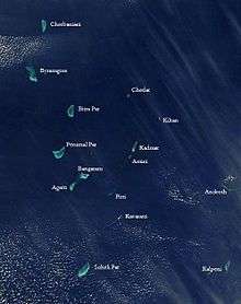 Satellite picture showing the atolls of the Lakshadweep except for Minicoy
 Map
Map A beach at Kavaratti, Lakshadweep.
 Kavaratti Main Road in the early morning.
 Kavaratti Aerial
References
- ↑ "Islandwise Area and Population - 2011 Census" (PDF). Government of Lakshadweep.
- ↑ Registration Plate Numbers added to ISO Code
- ↑ http://www.firstpost.com/business/why-only-98-cities-instead-of-100-announced-all-questions-answered-about-smart-cities-project-2410576.html
- ↑ Falling Rain Genomics, Inc - Kavaratti
- ↑ "Kavaratti Climate". Union Territory of Lakshadweep. Retrieved 2012-05-06.
- 1 2 3 4 "Kavaratti Island" (PDF). Union Territory of Lakshdweep. Retrieved 2012-05-06.
- ↑ "Kavaratti". India Guide. Retrieved 2012-05-06.
- ↑ Tehsils info
- ↑ "Kavaratti Islands, Lakshadweep". Must See India. Retrieved 2012-05-06.
- ↑ "A New Desalination Plant at Kavaratti to Supply Drinking Water from Monday". Ministry of Science and Technology, Government of India. May 20, 2005.
- ↑ "Desalination: India opens world's first low temperature thermal desalination plant". IRC International Water and Sanitation Centre. 31 May 2005.
External links
| Wikimedia Commons has media related to Kavaratti. |
 Lakshadweep travel guide from Wikivoyage