Raipur
| Raipur रायपुर (राजधानी) Capital of central india | |
|---|---|
| Metropolis | |
 Raipur  Raipur | |
| Coordinates: 21°15′N 81°38′E / 21.25°N 81.63°ECoordinates: 21°15′N 81°38′E / 21.25°N 81.63°E | |
| Country | India |
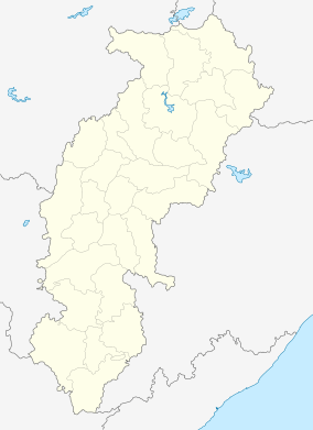
| State | Chhattisgarh |
| District | Raipur |
| Government | |
| • Type | Local Government |
| • Mayor | Shri Pramod Dubey |
| • District Collector | O P chowdhary (IAS) |
| • Municipal Commissioner | Rajat bansal (IAS) |
| Area rank | 1st in central india area_total_km2 = 226 |
| Elevation | 298.15 m (978.18 ft) |
| Population (2016)[1] | |
| • Metropolis | 1,456,406 |
| • Rank | 48th |
| • Metro[2] | 1,546,076 |
| Demonym(s) | Raipurian |
| Languages | |
| • Official | Hindi, English |
| • Regional | Hindi, Chhattisgarhi |
| Time zone | IST (UTC+5:30) |
| PIN | 492001 |
| Vehicle registration | CG-04 |
| Climate | Aw |
| Website |
www |

Raipur (/ˈraɪpʊər/ ![]() pronunciation ) is a city in the Raipur district of the Indian state of Chhattisgarh. It is the capital city of the state of Chhattisgarh and is the administrative headquarters of Raipur district. It is also the largest city in Chhattisgarh. It was formerly a part of Madhya Pradesh before the state of Chhattisgarh was formed on 1 November 2000.
pronunciation ) is a city in the Raipur district of the Indian state of Chhattisgarh. It is the capital city of the state of Chhattisgarh and is the administrative headquarters of Raipur district. It is also the largest city in Chhattisgarh. It was formerly a part of Madhya Pradesh before the state of Chhattisgarh was formed on 1 November 2000.
History
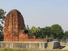
Raipur has been in existence since the 9th century; the old site and ruins of the fort can be seen in the southern part of the city. Raipur district is important historically and as a point of interest archaeologically. This district was once part of the Dakshina Kosala Kingdom and later considered part of the Maurya Empire. The 4th century AD king Samudragupta conquered this region and established his domination until the fifth–sixth century when the area came under the rule of Sarabhpuri kings. For some time in the fifth and sixth centuries, Nala kings dominated this area. Later on Somavanshi kings took control and ruled with Sirpur ("City of Wealth") as their capital. Mahashivgupta Balarjun was the mightiest emperor of this dynasty. His mother, the widow queen of Harshgupta of the Somavansh, Rani Vasata built the brick temple of Lakshman.
The Kalachuri dynasty kings of Tumman ruled the area for a long period making Ratanpur their capital. The old inscriptions of Ratanpur, Rajim and Khallari refer to the reign of Kalachuri kings. Raipur was the capital of a branch of the Kalachuri dynasty, whose rulers controlled the forts of Chhattisgarh for a considerable period.
It is believed that King Ramachandra established the city of Raipur and subsequently made it the capital of his kingdom. Another story about Raipur is that King Ramachandra's son Brahmdeo Rai had established Raipur. His capital was Khalwatika (now Khallari). This region had become the domain of Bhosle kings after Amarsingh Deo's death. With the death of Raghuji III, the territory was assumed by the British government from Bhonsla'a of Nagpur and Chhattisgarh was declared a separate division, the Chhattisgarh Division of the Central Provinces, with its headquarters at Raipur in 1852. At the time of the independence of India Raipur district was included in the Central Provinces and Berar.
Demographics
As of the 2011 census, Raipur Municipal Corporation had a population of 1,010,087, of which 519,286 are males and 490,801 are females —a sex ratio of 945 females per 1000 males, higher than the national average of 940 per 1000.[3] 124,471 children are in the age group of 0–6 years, of which 64,522 are boys and 59,949 are girls —a ratio of 929 girls per 1000 boys. There are 769,593 literates (420,155 males, 349,438 females). The effective literacy was 86.90%; male literacy was 92.39% and female literacy was 81.10%, significantly higher than the national average of 73.00%.[1][4]
The urban agglomeration had a population of 1,122,555, of which males constitute 578,339, females constitute 544,216 —a sex ratio of 941 females per 1000 males and 142,826 children are in the age group of 0–6 years. There are a total of 846,952 literates with an effective literacy rate of 86.45%.[2]
As an important regional centre and a city with a history stretching back more than a thousand years, Raipur has attracted people from different parts of Madhya Pradesh and neighbouring states. The population includes local ethnic Chhattisgarhis, North Indians, South Indians, and a few people from the North East. Local ethnic Chhattisgarhi comprises Kalar, Kurmi, Swarnkar, Teli, Koshta and Satnami communities. The city is also inhabited by the trading communities like Jayaswals, Baniyas, Agarwals, Jains, Gujaratis, and Marwaris. Due to close proximity with Odisha there are large numbers of Odia speaking population found in the city as well as in the state. The city is also home to an immigrant population that includes Sindhis. It also has a sizeable Bengali, Telugu, Malayalee and Maharashtrian population. Majority of the population in Raipur is Hindu. Muslims, Sikhs and Christians are minorities. Muslims primarily reside in such areas as Moudhapara (occupied by the immigrants from UP and Bihar), Baijnathpara, Chota Para,Raza Talab,Sanjay Nagar, Momin Para (Shia Islam community) and Byron Bazaar (which is named after a Briton who is supposed to have formed the place; Byron Bazar was once mostly inhabited by the Muslims from the "Madras Paltan" i.e. those serving in the British Army (Madras Regiment), and had occupied Byron Bazaar as a result of their regiment getting disbanded).The Sikhs residing at pandri, govindnagar, shyamnagar & tatibandh areas. The Christian population is scattered around the city. This city is also populated by the people of Kanwar and Gond community who are primarily tribals.
Geography and climate
| Raipur | ||||||||||||||||||||||||||||||||||||||||||||||||||||||||||||
|---|---|---|---|---|---|---|---|---|---|---|---|---|---|---|---|---|---|---|---|---|---|---|---|---|---|---|---|---|---|---|---|---|---|---|---|---|---|---|---|---|---|---|---|---|---|---|---|---|---|---|---|---|---|---|---|---|---|---|---|---|
| Climate chart (explanation) | ||||||||||||||||||||||||||||||||||||||||||||||||||||||||||||
| ||||||||||||||||||||||||||||||||||||||||||||||||||||||||||||
| ||||||||||||||||||||||||||||||||||||||||||||||||||||||||||||
Geography
Raipur is located near the centre of a large plain, sometimes referred as the "rice bowl of India", where hundreds of varieties of rice are grown.[5] The Mahanadi River flows to the east of the city of Raipur, and the southern side has dense forests. The Maikal Hills rise on the north-west of Raipur; on the north, the land rises and merges with the Chota Nagpur Plateau, which extends north-east across Jharkhand state. On the south of Raipur lies the Deccan Plateau.
Climate
Raipur has a tropical wet and dry climate, temperatures remain moderate throughout the year, except from March to June, which can be extremely hot. The temperature in April–May sometimes rises above 48 °C (118 °F).These summer months also have dry and hot winds. In summers, the temperature can also go up to 50 °C. The city receives about 1,300 millimetres (51 in) of rain, mostly in the monsoon season from late June to early October. Winters last from November to January and are mild, although lows can fall to 5 °C (41 °F).
| Climate data for Raipur (1901-1998) | |||||||||||||
|---|---|---|---|---|---|---|---|---|---|---|---|---|---|
| Month | Jan | Feb | Mar | Apr | May | Jun | Jul | Aug | Sep | Oct | Nov | Dec | Year |
| Average high °C (°F) | 28.0 (82.4) |
30.9 (87.6) |
35.8 (96.4) |
40.2 (104.4) |
42.1 (107.8) |
37.3 (99.1) |
31.3 (88.3) |
30.4 (86.7) |
31.8 (89.2) |
32.2 (90) |
30.2 (86.4) |
27.9 (82.2) |
33.2 (91.8) |
| Average low °C (°F) | 13.1 (55.6) |
15.9 (60.6) |
20.3 (68.5) |
24.8 (76.6) |
27.7 (81.9) |
26.2 (79.2) |
23.9 (75) |
23.8 (74.8) |
23.8 (74.8) |
21.3 (70.3) |
16.4 (61.5) |
12.6 (54.7) |
20.8 (69.4) |
| Average precipitation mm (inches) | 11.3 (0.445) |
15.6 (0.614) |
13.0 (0.512) |
15.1 (0.594) |
31.6 (1.244) |
196.4 (7.732) |
330.6 (13.016) |
355.4 (13.992) |
216.8 (8.535) |
50.8 (2) |
14.0 (0.551) |
7.5 (0.295) |
1,258.1 (49.531) |
| Source: IMD[6] | |||||||||||||
Transport

Railways
Raipur Junction railway station is situated on the Howrah-Nagpur-Mumbai line of the Indian Railways (via Bhusawal, Nagpur, Gondia, Bilaspur, Rourkela, Kharagpur) and is connected with some major cities like New Delhi, Mumbai, Bhopal, Jabalpur, Sambalpur, Saugor, Katni, Itarsi, Gondia, Bhubaneswar, Kolkata, Jamshedpur, Chennai, Bangalore, Hyderabad, Kota, Ahmedabad, Jaipur Vishakapatnam, etc. Raipur still lacks direct rail connectivity with Indore, Ujjain, Ratlam, Kolhapur, Jodhpur, etc. A branch line from Raipur to Vizianagaram via Mahasamund - Titlagarh originates from here and most of the produce of Chhattisgarh reaches Vishakhapatnam by this railway line. There is also a narrow gauge line connecting Raipur to Rajim and Dhamtari via Abhanpur, which is being converted to broad gauge and realigned to serve the city of Naya Raipur as well.
Suburbs Of Raipur
- Saraswati Nagar National Institute of Technology Raipur
- Pandri City Station {Metre Gauge}
- Sarona AIIMS Raipur & {Tatibandh}
- W. R. S. Colony {KhamTarai}
- Urkura
- Mandhar {Siltara} & {Vidhan Sabha}
- Mandir Hasoud
- Doongaji Colony
- Naya Raipur {Proposed Railway Station & Logistic Hub By CONCOR }
Roads
National Highways connecting Raipur to various cities:[7]
| National Highways number | Connecting cities | |
|---|---|---|
| NH 6 | Hajira-Dhule-Nagpur-Raipur- Sambalpur - Baharagora-Kolkata | |
| NH 43 | Raipur-Vizianagaram Junction with National Highway No. 5 near
Natavalasa | |
| NH 200 | Raipur-Bilaspur-Raigarh-Kanaktora-Jharsuguda-Kochinda-Deogarh-Talcher-Chandhikhol | |
| NH 217 | Raipur- Mahasamund - Gopalpur | |
| NH 12A | Raipur-Jhansi |
Asian Highway Number 46 - AH46 passes through Raipur
Airport

Swami Vivekananda Airport or Mana Airport is primary airport serving the state of Chhattisgarh.The airport is located, 15 km (9.3 mi) south of Raipur near Naya Raipur. After recent modernisation, is one of its kind in central India and presently connects Raipur to most of the major Metro city of India.
A new integrated terminal designed to handle 700 passengers (including 200 international flyers at a time) and covering an area of 18,500 m2 (4.6 acres) was inaugurated on 7 November 2012 by President of India Pranab Mukherjee. The new terminal will be used for domestic flights, while the proposed international terminal is being renovated to handle international operations.
Local transport
A city bus service is provided by Raipur City Bus Limited (RCBL) for the intra-city travel. Raipur Municipal Corporation launched the Raipur City Bus service on 25 February 2008. The company runs 40 buses out of which 32 are low floor Tata Starbus. Paratransit in the form of auto-rickshaws and tuk-tuk are available all over the city. 200 new city buses under JNNURM have been inducted by Raipur Nagar Nigam Transport Limited (RNNTL), which serve the Raipur and connect Naya Raipur also.
Raipur BRTS (iBUS)-Raipur BRTS is a bus rapid transit system with air-conditioned (AC) and non-AC buses. Some of these buses are equipped with services like GPS and IVR which are used to track the position of the bus with information displayed on LED displays installed at the bus stops the BRTS operation between the Raipur to Naya Raipur Prime Minister Narendra Modi launches Naya Raipur BRTS in Naya Raipur on Nov 1, 2016.
Economy
Historically, when Raipur was a part of Madhya Pradesh, it was the second major commercial centre in Madhya Pradesh after Indore. Traditionally, Raipur's economy has been based on agricultural-processing, Steel, Cement, Alloy, Poha and Rice. The city is located centrally in the state of Chhattisgarh, and now serves as a regional hub for trade and commerce for a variety of local agricultural and forest products.
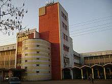
The traditional face of city has changed with Raipur becoming an important regional commercial and industrial destination for the coal, power, plywood, steel and aluminium industries. Raipur is the largest market of steel in India. Raipur is among the richest cities and India’s biggest iron market; there are about 200 steel rolling mills, 195 sponge iron plants, more than 6 steel plants, more than 60 plywood factories, 500 agro-industries and more than 35 ferro-alloy plants. There are more than 800 rice milling plants, and all major and local cement manufacturing companies (Century Cement, Ambuja, Grasim, Lafarg) have a presence in the city.
Raipur also has a big chemical plant which produces formalin and distributes throughout the country.
Education
Raipur has become the educational hub of Central India due to presence of many institutes of National importance in Engineering, Management, Medical and Law. It is the only city in India which is home to IIM, NIT, AIIMS, Hidayatullah National Law University, and IIIT.[8] IIT Chhattisgarh is proposed at Bhilai which is 30 km from Raipur.
Premier institutes
- Indian Institute of Management (IIM) Raipur
- National Institute of Technology (NIT) Raipur
- All India Institute of Medical Sciences (AIIMS) Raipur
- Hidayatullah National Law University (HNLU) Raipur
- International Institute of Information Technology (IIIT) Naya Raipur
Government universities
- Pandit Ravishankar Shukla University
- Indira Gandhi Agricultural University
- Kushabhau Thakre Patrakarita Avam Jansanchar University
- Chhattisgarh Swami vivekanand technical university
Private universities and deemed universities
- AMITY University, Raipur
- ITM University, Raipur
- MATS University, Raipur
- ICFAI University, Raipur
- Kalinga University, Raipur
- Indian Institute of Technology (IIT)-Kharagpur Extension, Raipur
Commerce, Engineering and management colleges
- Bhilai Institute of Technology, Raipur (BIT, Raipur)
- Raipur Institute of Technology
- New Government Engineering College, Raipur
- AVS Presidency International College, Raipur(APIC)
- Disha institute of management and technology(DIMAT)
- Shri Shankaracharya Institute of Professional Management and Technology, Raipur (SSIPMT)
- Pragati College of Engineering and Management, Raipur|Pragati College of Engineering and Management
- Central college of Engineering and Management, kabir nagar, Raipur
- Professional Institute of Engineering and Technology, Raipur.[PIETECH]
Medical colleges
- All India Institute of Medical Sciences (AIIMS), Raipur
- Pt Jawaharlala Nehru Medical College, Raipur
- Governmenet Ayurvedic Medical College
- Government Homeopathic College
- Government Dental College, Raipur
- Raipur Institute Of Medical Sciences
Primary and secondary education
There are almost all major nationwide school chains in the city resulting in sound academic environment in the city. Also, the city has almost all premier coaching institutes for competitive exams such as Resonance, FIIT-JEE, Aakash Institute, PT-Education, TIME, Career Launcher etc.
The major schools include:
- Ryan International School, Raipur
- Delhi Public School,Raipur
- Kanger Valley Academy, Raipur
- Kendriya vidyalaya WRS colony RAIPUR
- Tilak Bharati Hr. Sec School, Tilak Nagar, Raipur
- Rashtriya Higher Secondary School (RHSS), Kutchury Chowk, Raipur
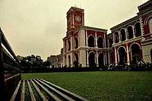
- Rajkumar College, established 1882
- Adarsh vidyalaya Devendra Nagar
- Holy Cross Senior Secondary School Kapa
Apart from above mentioned schools, there are several other schools affiliated to CBSE, ICSE, as well as state board in both English and Hindi medium.
Media
News channels
Many local news channels are telecast from Raipur in Hindi :
| News Channels | Language | Notes |
|---|---|---|
| CG 24 news channel CG | Hindi | |
| IBC 24 | Hindi | |
| Khabar Bharati | Hindi | |
| Grand News (Cable Network) | Hindi | |
| ETV MP Chhattisgarh | Hindi | |
| Sadhna News | Hindi | |
| Sahara Samaye | Hindi | |
| Zee MP CG | Hindi | |
| India News MP CG | Hindi | |
| Bansal News | Hindi | |
| Abhi Tak (Cable Network) | Hindi |
Newspaper
Many national and local newspapers are published from Raipur both in Hindi and English:
| Newspaper | Language | Notes |
|---|---|---|
| Dainik Bhaskar | Hindi | |
| Dainik Vishwa Pariwar | Hindi | |
| Patrika | Hindi | |
| Nava Bharat | Hindi | |
| Deshbandhu | Hindi | |
| Nai Duniya | Hindi | |
| Haribhoomi | Hindi | |
| The Central Chronicle | English | |
| The Times of India | English | |
| Hindustan Times | English | |
| Hindustan | Hindi | |
| The Hitavada | English | |
| The Pioneer | English | |
| Business Standard | English, Hindi | |
| Business Bhaskar | English, Hindi |
Radio
Raipur has 6 Radio stations.
Akashvani (radio broadcaster)(All India Radio)
Radio Tadka - 95 FM
Radio Rangeela - 104.8 FM
Vividh Bharti. - 101.6 FM
Tourism
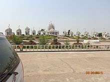
- Kevalya Dham: Jain temple of white marble is on NH 6 and is one of major tourist attraction. The temple is also known as Sri Adinath Jain Shwetambar Tirth collection of 26 small and big Jain temples magnificently built with marbles. The temple enshrines the idols of all 24 Tirthankars in small temples with one large temple complex with idol of Rishabhdev. On the corner wall within the shrine carries a detailed description of Sri Shatrunjay Maha Tirtha. A dadabari is also present near this temple. This Temple also has a dharamshala equipped with all modern facilities. Tourists and devotees from far off places in India visit these temples on a regular basis.
- sadani darbar[9]
- Mahant Ghasidas Museum,[10] built in 1875 by Raja Mahant Ghasidas, king of the erstwhile Rajnandgaon state.
- Guru Tegh Bahadur Museum, built in honour of Sikh Guru Tegh Bahadur situated near Ghasidas museum.
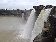
Kanha National Park, Achanakmar Wildlife Sanctuary, Amarkantak, Bhoramdeo Temple, Dongargarh, Setganga, Sirpur, Champaran, Rajim, Chitrakot Falls, Indravati National Park, Kanger Valley National Park, Gangrel Dam and Murrum Silli Dam are the other nearby attractions.
Notable people associated with Raipur
- Swami Vivekananda spent 2 years of his teenage in Raipur from 1877 till 1879 when his father was transferred here.[11]
- Ravishankar Shukla, the 1st Chief Minister of the state of Madhya Pradesh, spent his childhood and was educated in Raipur.
- Justice Mohammad Hidayatullah, former Chief Justice of India and acting President of India, received his primary education at the Government High School of Raipur till 1922.
- Veer Narayan Singh,[12][13] Freedom fighter, He was jailed at Raipur by British Army.
- Osho started his teaching career as a lecturer in Raipur Sanskrit College in 1957.[14]
- Habib Tanvir, noted theatre artist and playwright, was born in Raipur in 1923.
- K. S. Sudarshan, the former chief of the Rashtriya Swayamsevak Sangh, was born in Raipur in 1931.Coincidentally he also died in Raipur on 15 Sep 2012
- Vidya Charan Shukla, former Union Minister and 9 times parliamentarian, was born in Raipur.
- Harshad Mehta, the infamous stock broker, spent his childhood in Raipur after his parents shifted here from Mumbai. He received his education from Holy Cross English School, Byron Bazar.
- Lucky Ali, noted Bollywood singer/composer/actor did a part of his schooling from Rajkumar College, Raipur[15]
- Anurag Basu, noted Bollywood movie director was born in Raipur and later moved to the neighbouring city of Bhilai
- Shekhar Sen World-famous musical monoact player, born and brought up at Raipur.
Naya Raipur
Naya Raipur (New Raipur) is the new city of Chhattisgarh.[16] Located between National Highways NH-6 and NH-43. It is 17 km away in the south-east direction from the current capital Raipur. Swami Vivekananda Airport separates the old and new cities. Naya Raipur is serving as the administrative capital of the State and also cater to the infrastructural needs of industry and trade in the region.
Naya Raipur spreads over an area of about 8000 hectares. Naya Raipur is India's fourth planned capital city after Gandhinagar in Gujarat; Chandigarh serting both Punjab and Harayana; and Bhubaneshwar in Odisha.
See also
References
- 1 2 "Cities having population 1 lakh and above, Census 2011" (PDF). The Registrar General & Census Commissioner, India. Retrieved 25 June 2014.
- 1 2 "Urban Agglomerations/Cities having population 1 lakh and above" (PDF). censusindia. The Registrar General & Census Commissioner, India. Retrieved 25 June 2014.
- ↑ "Sex Ratio". The Registrar General & Census Commissioner, India. Retrieved 2 September 2014.
- ↑ "Chapter–3 (Literates and Literacy rate)" (PDF). Registrar General and Census Commissioner of India. Retrieved 2 September 2014.
- ↑ "Chhattisgarh Details, Chhattisgarh Online, Chhattisgarh Information, Chhattisgarh State". Walkincg.com. Retrieved 2012-10-04.
- ↑ "Raipur Climatological Table (1971-2000)". Retrieved 18 July 2012.
- ↑ "National Highways and their Length" (PDF). Retrieved 2012-10-04.
- ↑ http://iiitnr.choice.gov.in/
- ↑ "sadani darbar".
- ↑ "Mahant Ghasidas Museum", QuickSearch.in, Retrieved 2016-10-10.
- ↑ "Reminiscences of Swami Vivekananda - Frank Parlato Jr. - Bhupendranath Datta". Vivekananda.net. Retrieved 2012-10-04.
- ↑ "EXECUTION OF VEER NARAYAN SINGH". indianpost.com.
- ↑ Veer Narayan Singh
- ↑ Carter 1990, p. 44
- ↑ "Songs of Lucky Ali · Bollywood Songs". Jhunkar.com. Retrieved 2012-10-04.
- ↑ "Naya Raipur spurs Afghans to develop New Kabul City". The Times of India.
External links
| Wikimedia Commons has media related to Raipur. |
| Governance | 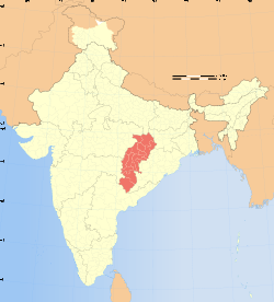 | |
|---|---|---|
| Topics | ||
| Districts | ||
| Cities | ||
| ||