Herr, Indiana
| Herr | |
|---|---|
| Unincorporated community | |
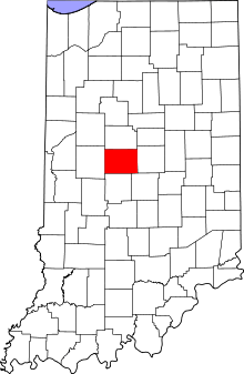 Boone County's location in Indiana | |
 Herr Location in Boone County | |
| Coordinates: 39°57′20″N 86°25′54″W / 39.95556°N 86.43167°WCoordinates: 39°57′20″N 86°25′54″W / 39.95556°N 86.43167°W | |
| Country | United States |
| State | Indiana |
| County | Boone |
| Township | Perry |
| Elevation | 968 ft (295 m) |
| ZIP code | 46052 |
| FIPS code | 18-33196[1] |
| GNIS feature ID | 436061[2] |
Herr is an unincorporated community in Perry Township, Boone County, Indiana.
Geography
Herr is located at 39°57′20″N 86°25′54″W / 39.95556°N 86.43167°W.
References
- ↑ "American FactFinder". United States Census Bureau. Retrieved 2008-01-31.
- ↑ "Herr, Indiana". Geographic Names Information System. United States Geological Survey. Retrieved 2009-10-17.
Municipalities and communities of Boone County, Indiana, United States | ||
|---|---|---|
| City | ||
| Towns | ||
| Townships | ||
| Unincorporated communities |
| |
| Footnotes | ‡This populated place also has portions in an adjacent county or counties | |
This article is issued from Wikipedia - version of the 9/3/2016. The text is available under the Creative Commons Attribution/Share Alike but additional terms may apply for the media files.