Hanoverton Canal Town District
|
Hanoverton Canal Town District | |
|
Spread Eagle Tavern (1837) | |
  | |
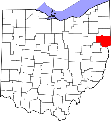
| Location | U.S. 30, Hanoverton, Ohio |
|---|---|
| Coordinates | 40°45′08″N 80°56′07″W / 40.75222°N 80.93528°WCoordinates: 40°45′08″N 80°56′07″W / 40.75222°N 80.93528°W |
| Area | 23 acres (9.3 ha) |
| Built | 1817 |
| NRHP Reference # | 77001050[1] |
| Added to NRHP | August 3, 1977 |
.JPG)
The Hanoverton Canal Town District is a 23-acre (9.3 ha) area along Route 30 in Hanoverton, Ohio characterized by examples of canal-era architecture of the early to mid-19th century.[2] The district is located within the town of Hanoverton, Ohio which was settled and platted in 1813.[3]
Within the district are 30 brick and frame houses built between 1817 and 1874 that have remained unchanged over the years. The simple frame houses were originally built during the construction of the Hanoverton and the Beaver and Sandy canals.[2][4]
References
- ↑ National Park Service (2010-07-09). "National Register Information System". National Register of Historic Places. National Park Service.
- 1 2 "Hanoverton Canal Town District". historic and notable landmarks of the u.s. LandmarkHunter.com. Retrieved 14 August 2011.
- ↑ "Historical Sketch of Columbiana County". columbianacounty.org. Retrieved 14 August 2011.
- ↑ Editorial Staff (2008). Ohio Historic Places Dictionary. North American Book Dist LLC. p. 161. ISBN 978-1-878592-70-5.


This article is issued from Wikipedia - version of the 11/28/2016. The text is available under the Creative Commons Attribution/Share Alike but additional terms may apply for the media files.