Beginning Point of the U.S. Public Land Survey
|
Beginning Point of the U.S. Public Land Survey | |
|
Front of the monument | |
  | |
| Location | East Liverpool, Ohio |
|---|---|
| Coordinates | 40°38′32.61″N 80°31′9.76″W / 40.6423917°N 80.5193778°WCoordinates: 40°38′32.61″N 80°31′9.76″W / 40.6423917°N 80.5193778°W |
| Area | less than one acre |
| Built | 1786 |
| NRHP Reference # | 66000606[1] |
| Significant dates | |
| Added to NRHP | October 15, 1966 |
| Designated NHL |
June 23, 1965 [2] |
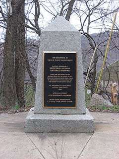
The Beginning Point of the U.S. Public Land Survey is a monument at the border between the U.S. states of Ohio and Pennsylvania, on the north side of the Ohio River. It is near the three-way intersection of Ohio, Pennsylvania, and the northern tip of West Virginia, in both the Pittsburgh metropolitan area and the East Liverpool micropolitan area. It is significant as being the point from which the Public Land Survey System was performed, starting in 1785, which would open what was then the Northwest Territory for settlement. The survey was "the first mathematically designed system and nationally conducted cadastral survey in any modern country" and is "an object of study by public officials of foreign countries as a basis for land reform."[3] It was conducted in the late 18th century by Geographer of the U.S. Thomas Hutchins surveying the Seven Ranges.
Built in 1881,[4] it was declared a National Historic Landmark in 1965.[2][3]
The area that is landmarked includes a part of Ohio and a part of Pennsylvania. A plaque at the site states that the true starting point was 1,112 feet further south.[5] The commemorative site is located about 2 miles east of the center of East Liverpool on Ohio State Route 39 and Pennsylvania Route 68.
See also
References
- ↑ National Park Service (2010-07-09). "National Register Information System". National Register of Historic Places. National Park Service.
- 1 2 "Beginning Point of the U.S. Public Land Survey". National Historic Landmark summary listing. National Park Service. Archived from the original on 23 October 2007. Retrieved 2007-11-08.
- 1 2 Joseph S. Mendinghall (December 27, 1974). "National Register of Historic Places Inventory-Nomination: Beginning Point / Beginning Point of the U.S. Public Land Survey" (pdf). National Park Service.
- ↑ Inscription on monument, pictured here
- ↑ Inscription on monument, pictured here
| Wikimedia Commons has media related to Beginning Point of the U.S. Public Land Survey. |
| Topics | |
|---|---|
| Lists by states |
|
| Lists by insular areas | |
| Lists by associated states | |
| Other areas | |
| |