Gibbon River
| Gibbon River | |
|---|---|
|
Bison grazing near the Gibbon River in Yellowstone National Park | |
| Basin | |
| Main source |
6,795 feet (2,071 m) 44°45′10″N 110°33′57″W / 44.75278°N 110.56583°W |
| River mouth | 44°38′32″N 110°51′56″W / 44.64222°N 110.86556°WCoordinates: 44°38′32″N 110°51′56″W / 44.64222°N 110.86556°W[1] |
| River system | Missouri River |
| Basin size | 126 square miles (330 km2)[2] |
| Physical characteristics | |
| Length | ~25 miles (40 km)[3] |
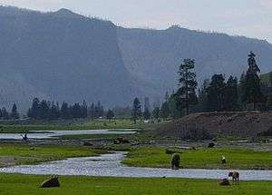
The Gibbon River flows east of the Continental Divide in Yellowstone National Park, in northwestern Wyoming, the Northwestern United States. Along with the Firehole River, it is a major tributary of the Madison River, which itself is a tributary of the Missouri River.
Description
The Gibbon River rises in the center of the park at Grebe Lake. It flows for a short distance into Wolf Lake. Below Wolf Lake, the river flows through Virginia Cascades into the Norris valley. It flows near the Norris Geyser Basin and through the Gibbon Geyser Basin. From there it flows through the Gibbon River Canyon to its confluence with the Firehole River to form the Madison River. Early maps listed the river as Gibbons Fork or the East Fork of the Madison River. The river between Norris and Madison Junction is paralleled by the Grand Loop Road. The river, along with Gibbon Falls, is named for Colonel John Gibbon,[4] U.S. Army who participated in the 1872 Hayden Geological Survey of Yellowstone.
Angling
The Gibbon River is a popular trout fishing destination. The upper section of river has very difficult access being choked with thick forests and lots of downed timber. The fish, consisting of brook trout, rainbow trout and grayling are all on the small side, rarely exceeding 10 inches (250 mm). Below Gibbon Falls access is excellent and the river has a healthly mix of rainbow and brown trout. The lower river receives a good run of spawning browns in the fall.[5][6]
The Gibbon River is fly fishing only and catch and release below Gibbon Falls. Above the falls, any grayling or cutthroat trout caught must be released. An unlimited number of brook, rainbow and/or brown trout may be harvested daily in the waters above the falls.[7]
Gallery
| Wikimedia Commons has media related to Gibbon River. |
| Images of the Gibbon River | ||||||||||
|---|---|---|---|---|---|---|---|---|---|---|
|


See also
- Gibbon Falls
- Grand Loop Road Historic District
- Angling in Yellowstone National Park
- Fishes of Yellowstone National Park
- Tributaries of the Missouri River
References
- ↑ "Gibbon River". Geographic Names Information System. United States Geological Survey.
- ↑ "USGS Site Map for Montana, USGS 06037100 Gibbon River at Madison Jct, YNP". Retrieved 2012-06-18.
- ↑ Trails Illustrated-Mammoth Hot Springs, Yellowstone National Park (303) (Map) (Revised ed.). 1:63360. National Geographic Maps. 2008. ISBN 1-56695-304-9.
- ↑ Gannett, Henry (1905). The Origin of Certain Place Names in the United States. Govt. Print. Off. p. 137.
- ↑ Mathews, Craig; Molinero, Clayton (1997). The Yellowstone Fly-Fishing Guide-A authoritative guide to the waters of Yellowstone National Park. Guilford, CT: The Lyons Press. ISBN 1-55821-545-X.
- ↑ Parks, Richard (1998). Fishing Yellowstone National Park. Helena, MT: Falcon Press. ISBN 1-56044-625-0.
- ↑ "2013 Yellowstone National Park Fishing Regulations". National Park Service. Retrieved 2013-05-20.
Further reading
- Back, Howard (1938). The Waters of the Yellowstone with Rod and Fly. New York: Dodd & Mead.
- Parks, Richard (1998). Fishing Yellowstone National Park. Helena, MT: Falcon Press. ISBN 1-56044-625-0.
- Brooks, Charles E. (1979). The Living River-A Fisherman's Intimate Profile of the Madison River Watershed--Its History, Ecology, Lore and Angling Opportunities. Garden City, NJ: Nick Lyons Books. ISBN 0-385-15655-3.
- Mathews, Craig; Molinero, Clayton (1997). The Yellowstone Fly-Fishing Guide-A authoritative guide to the waters of Yellowstone National Park. Guilford, CT: The Lyons Press. ISBN 1-55821-545-X.
- Brooks, Charles E. (1984). Fishing Yellowstone Waters. Clinton, NJ: New Win Publishing Inc. ISBN 0-8329-0353-1.
Yellowstone National Park - Norris and Madison | ||
|---|---|---|
Geothermal features, historic structures and other attractions in the Norris and Madison Junction areas | ||
| Norris Geyser Basin |  | |
| Gibbon Geyser Basin | ||
| Structures and History | ||
| Geography and Geology | ||
| ||
Cheyenne (capital) | |
| Topics |
|
| Society |
|
| Regions | |
| Cities | |
| Counties | |