Douglas, Wyoming
| Douglas, Wyoming | |
|---|---|
| City | |
|
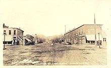
Center Street (city center), view to the west | |
| Motto: "Home of the Jackalope" | |
 Douglas, Wyoming Location of Douglas, Wyoming | |
| Coordinates: 42°45′22″N 105°23′4″W / 42.75611°N 105.38444°WCoordinates: 42°45′22″N 105°23′4″W / 42.75611°N 105.38444°W | |
| Country | United States |
| State | Wyoming |
| County | Converse |
| Government | |
| • Mayor | Bruce Jones |
| Area[1] | |
| • Total | 4.76 sq mi (12.33 km2) |
| • Land | 4.58 sq mi (11.86 km2) |
| • Water | 0.18 sq mi (0.47 km2) |
| Elevation | 4,836 ft (1,474 m) |
| Population (2010)[2] | |
| • Total | 6,120 |
| • Estimate (2012[3]) | 6,280 |
| • Density | 1,336.2/sq mi (515.9/km2) |
| Time zone | Mountain (MST) (UTC-7) |
| • Summer (DST) | MDT (UTC-6) |
| ZIP code | 82633 |
| Area code(s) | 307 |
| FIPS code | 56-21125[4] |
| GNIS feature ID | 1587750[5] |
| Website | City of Douglas Wyoming |

Douglas is a city in Converse County, Wyoming, United States. The population was 6,120 at the 2010 census. It is the county seat of Converse County[6] and the home of the Wyoming State Fair.
Its former railroad passenger depot is listed on the National Register of Historic Places.
History
Douglas was platted in 1886[7] when the Wyoming Central Railway (later the Chicago and North Western Transportation Company) established a railway station; the settlement had been in existence since 1867 when Fort Fetterman was built and was first known as “Tent City”[8] before it was officially named "Douglas", after Senator Stephen A. Douglas.[9] It served as a supply point, warehousing and retail, for surrounding cattle ranches, as well as servicing railway crews, cowboys and the troops of the U.S. Army stationed at Fort Fetterman.
Douglas was the home of a World War II internment camp.
Geography
Douglas is located at 42°45′22″N 105°23′4″W / 42.75611°N 105.38444°W (42.756008, -105.384555).[10]
According to the United States Census Bureau, the city has a total area of 4.76 square miles (12.33 km2), of which, 4.58 square miles (11.86 km2) is land and 0.18 square miles (0.47 km2) is water.[1]
Climate
Douglas has a semi-arid climate (Köppen climate classification BSk).
| Climate data for Douglas, Wyoming | |||||||||||||
|---|---|---|---|---|---|---|---|---|---|---|---|---|---|
| Month | Jan | Feb | Mar | Apr | May | Jun | Jul | Aug | Sep | Oct | Nov | Dec | Year |
| Record high °F (°C) | 65 (18) |
69 (21) |
77 (25) |
86 (30) |
93 (34) |
103 (39) |
103 (39) |
101 (38) |
97 (36) |
88 (31) |
76 (24) |
68 (20) |
103 (39) |
| Average high °F (°C) | 37.4 (3) |
41.6 (5.3) |
49.2 (9.6) |
57.5 (14.2) |
67.2 (19.6) |
79.0 (26.1) |
86.4 (30.2) |
85.3 (29.6) |
74.8 (23.8) |
62.2 (16.8) |
46.3 (7.9) |
38.6 (3.7) |
60.46 (15.82) |
| Daily mean °F (°C) | 23.7 (−4.6) |
28.3 (−2.1) |
35.9 (2.2) |
43.5 (6.4) |
53.1 (11.7) |
63.5 (17.5) |
70.3 (21.3) |
68.8 (20.4) |
58.1 (14.5) |
46.2 (7.9) |
32.9 (0.5) |
25.0 (−3.9) |
45.78 (7.65) |
| Average low °F (°C) | 9.9 (−12.3) |
14.9 (−9.5) |
22.5 (−5.3) |
29.5 (−1.4) |
39.0 (3.9) |
47.9 (8.8) |
54.2 (12.3) |
52.2 (11.2) |
41.3 (5.2) |
30.1 (−1.1) |
19.5 (−6.9) |
11.4 (−11.4) |
31.03 (−0.54) |
| Record low °F (°C) | −38 (−39) |
−33 (−36) |
−19 (−28) |
−12 (−24) |
16 (−9) |
28 (−2) |
34 (1) |
29 (−2) |
11 (−12) |
−6 (−21) |
−24 (−31) |
−41 (−41) |
−41 (−41) |
| Average precipitation inches (mm) | 0.38 (9.7) |
0.42 (10.7) |
0.78 (19.8) |
1.64 (41.7) |
2.50 (63.5) |
1.42 (36.1) |
1.56 (39.6) |
0.91 (23.1) |
1.07 (27.2) |
0.80 (20.3) |
0.74 (18.8) |
0.36 (9.1) |
12.58 (319.6) |
| Source #1: NOAA (normals, 1971–2000)[11] | |||||||||||||
| Source #2: The Weather Channel (Records)[12] | |||||||||||||
Demographics
| Historical population | |||
|---|---|---|---|
| Census | Pop. | %± | |
| 1890 | 491 | — | |
| 1900 | 734 | 49.5% | |
| 1910 | 2,246 | 206.0% | |
| 1920 | 2,294 | 2.1% | |
| 1930 | 1,917 | −16.4% | |
| 1940 | 2,205 | 15.0% | |
| 1950 | 2,544 | 15.4% | |
| 1960 | 2,822 | 10.9% | |
| 1970 | 2,677 | −5.1% | |
| 1980 | 6,030 | 125.3% | |
| 1990 | 5,076 | −15.8% | |
| 2000 | 5,288 | 4.2% | |
| 2010 | 6,120 | 15.7% | |
| Est. 2015 | 6,531 | [13] | 6.7% |
| [14] | |||
2010 census
As of the census[2] of 2010, there were 6,120 people, 2,546 households, and 1,613 families residing in the city. The population density was 1,336.2 inhabitants per square mile (515.9/km2). There were 2,788 housing units at an average density of 608.7 per square mile (235.0/km2). The racial makeup of the city was 94.4% White, 0.3% African American, 0.8% Native American, 0.2% Asian, 2.2% from other races, and 2.0% from two or more races. Hispanic or Latino of any race were 7.6% of the population.
There were 2,546 households of which 34.6% had children under the age of 18 living with them, 47.7% were married couples living together, 10.3% had a female householder with no husband present, 5.4% had a male householder with no wife present, and 36.6% were non-families. 30.7% of all households were made up of individuals and 9.8% had someone living alone who was 65 years of age or older. The average household size was 2.37 and the average family size was 2.98.
The median age in the city was 35 years. 27.7% of residents were under the age of 18; 8.2% were between the ages of 18 and 24; 27.5% were from 25 to 44; 25.8% were from 45 to 64; and 10.8% were 65 years of age or older. The gender makeup of the city was 50.0% male and 50.0% female.
2000 census
As of the census[4] of 2000, there were 5,288 people, 2,118 households, and 1,423 families residing in the city. The population density was 1,035.0 people per square mile (399.6/km²). There were 2,385 housing units at an average density of 466.8 per square mile (180.2/km²). The racial makeup of the city was 94.12% White, 0.06% African American, 0.78% Native American, 0.13% Asian, 0.02% Pacific Islander, 3.63% from other races, and 1.27% from two or more races. Hispanic or Latino of any race were 6.64% of the population.
There were 2,118 households out of which 36.6% had children under the age of 18 living with them, 53.7% were married couples living together, 10.0% had a female householder with no husband present, and 32.8% were non-families. 28.7% of all households were made up of individuals and 11.5% had someone living alone who was 65 years of age or older. The average household size was 2.45 and the average family size was 3.04.
In the city the population was spread out with 28.5% under the age of 18, 8.0% from 18 to 24, 29.8% from 25 to 44, 21.8% from 45 to 64, and 11.9% who were 65 years of age or older. The median age was 35 years. For every 100 females there were 94.4 males. For every 100 females age 18 and over, there were 91.5 males.
The median income for a household in the city was $36,944, and the median income for a family was $44,900. Males had a median income of $36,489 versus $18,662 for females. The per capita income for the city was $17,634. About 11.9% of families and 14.1% of the population were below the poverty line, including 19.6% of those under age 18 and 14.7% of those age 65 or over.
Education
Public education in the city of Douglas is provided by Converse County School District #1. Zoned campuses include Douglas Primary School (grades k-1), Douglas Intermediate School (grades 2-3), Douglas Upper Elementary School (grades 4-5), Douglas Middle School (grades 6-8), Douglas High school(grades 9-12). Douglas is also home to the branch campus of Eastern Wyoming College, one of the state's seven community colleges.
Culture
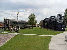
(left: the CB&Q dining car #196; right: the CB&Q steam locomotive #5633.)
Douglas is located on the banks of the North Platte River, and is named for Stephen A. Douglas, U.S. Senator. The city grew after it was designated a stop on the Fremont, Elkhorn and Missouri Valley Railroad. Railroads brought settlers and pioneers west; some stayed and others continued on. Douglas' location affords excellent access to nearby sights. Medicine Bow National Forest is located nearby, as is Thunder Basin National Grassland and Ayres Natural Bridge. In 1996 Douglas was listed by Norman Crampton as one of The 100 Best Small Towns in America.
The former Fremont, Elkhorn and Missouri Valley Railroad Passenger Depot in Douglas is included on the National Register of Historic Places.[15] The Douglas Chamber of Commerce and the Douglas Railroad Interpretive Center is located in the depot. The free of charge exhibition outside contains eight railroad vehicles, one steam locomotive with tender and seven cars.[16]
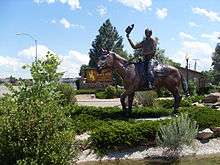
Horse culture
Since Fort Fetterman days, Douglas has been a center of American horse culture. The remains of the first winner of American racing's Triple Crown, thoroughbred Sir Barton, are buried here. Today, Douglas is the location of the Wyoming State Fair, held every summer and known for its rodeo and animal competitions. Also on the fairgrounds is the Wyoming Pioneer Memorial Museum, a collection of pioneer and Native American relics pertaining to the history of Converse County.
Jackalopes

In 1932, the jackalope legend in the United States was attributed by the New York Times to Douglas Herrick (1920−2003) of Douglas, and thus the city was named the "Home of the Jackalope" by the state of Wyoming in 1985. Douglas has issued Jackalope Hunting licenses to tourists. The tags are good for hunting during official Jackalope season, which occurs for only one day, June 31.
According to the Douglas Chamber of Commerce, a 1930s hunting trip for jackrabbits led to the idea of a Jackalope. Herrick and his brother had studied taxidermy by mail order as teenagers. When the brothers returned from a hunting trip, Herrick tossed a jackrabbit carcass into the taxidermy shop, which rested beside a pair of deer antlers. The accidental combination of animal forms sparked Douglas Herrick's idea for a jackalope.[17]
Wyoming State Fair
Each August Douglas hosts the Wyoming State Fair, not to be confused with Cheyenne Frontier Days Rodeo held in late July. The fair includes a carnival midway, live entertainment, and its own rodeo. On August 12, 2009, the fair hosted country music star John Anderson. The centennial fair in 2012 attracted sixty thousand persons, large by Wyoming standards; the Dierks Bentley concert was the first ever sold-out show in the fair.[18]
The 101st fair opened in Douglas on August 10, 2013; it corresponds with the centennial of the Wyoming State 4-H Club, an active group in the annual fair. Fair performers will include country musicians Hunter Hayes and Brantley Gilbert.[18]
Transportation
Highways
 I-25 North-South Interstate running from New Mexico to Wyoming; runs concurrent with US 87 through Douglas.
 I-25 Bus. I-25 Business, an alternate Business Route of I-25, running through the center of Douglas.[19][20]
 WYO 59
 WYO 91
 WYO 93
 WYO 94
 WYO 96
Airport
Air service is available 58 miles west of Douglas at Casper/Natrona County International Airport. The airport is located west of Casper, just off of US Highway 26. Passenger flights are offered by United Express (SkyWest Airlines), Delta Connection (SkyWest Airlines), and Allegiant Airlines.
Radio stations
- KKTY (AM) 1470 and 93.3FM, Classic Hits, Wyoming Cowboys, Denver Broncos, Colorado Rockies
- KKTY-FM 100.1, Full-Service Country
- KKTS-FM 99.3, Hot Adult Contemporary
Notable people
- David R. Edwards (1938-2013), Republican member of the Wyoming House of Representatives (2001-2008), member of the Douglas City Council (1995-2001), Converse County commissioner (2009-2012), and a 30-year veteran of the United States Navy, interred at Douglas Park Cemetery[21]
- Doris Shannon Garst (1894-1981), a native of Ironwood, Michigan, was a writer of children's books, histories and biographies. Her first book, The Story of Wyoming, (1938) started her off on a writing career. She published under the name Shannon Garst & was married to local attorney Joseph Garst.[22]
- Michael John Sullivan, Governor of Wyoming, 1987–1995
References
- 1 2 "US Gazetteer files 2010". United States Census Bureau. Retrieved 2012-12-14.
- 1 2 "American FactFinder". United States Census Bureau. Retrieved 2012-12-14.
- ↑ "Population Estimates". United States Census Bureau. Retrieved 2013-06-01.
- 1 2 "American FactFinder". United States Census Bureau. Retrieved 2008-01-31.
- ↑ "US Board on Geographic Names". United States Geological Survey. 2007-10-25. Retrieved 2008-01-31.
- ↑ "Find a County". National Association of Counties. Retrieved 2011-06-07.
- ↑ Chicago and North Western Railway Company (1908). A History of the Origin of the Place Names Connected with the Chicago & North Western and Chicago, St. Paul, Minneapolis & Omaha Railways. p. 65.
- ↑ American Automobile Association (2002) Tourbook: Idaho, Montana & Wyoming AAA Pub;ishing, Heathrow, Florida, p. 148 ISSN 0363-2695
- ↑ "Profile for Douglas, Wyoming". ePodunk. Retrieved 2010-05-28.
- ↑ "US Gazetteer files: 2010, 2000, and 1990". United States Census Bureau. 2011-02-12. Retrieved 2011-04-23.
- ↑ "Climatography of the United States NO.81" (PDF). National Oceanic and Atmospheric Administration. Retrieved January 13, 2011.
- ↑ "Monthly Averages for Douglas, WY". The Weather Channel. Retrieved January 13, 2011.
- ↑ "Annual Estimates of the Resident Population for Incorporated Places: April 1, 2010 to July 1, 2015". Retrieved July 2, 2016.
- ↑ "Historical Decennial Census Population for Wyoming Counties, Cities, and Towns". Wyoming Department of State / U.S. Census Bureau. Retrieved 2008-06-30.
- ↑ Fremont, Elkhorn & Missouri Valley Railroad Passenger Depot in Douglas, Wyoming. Wyoming State Historic Preservation Office. Includes a photograph.
- ↑ Douglas Railroad Interpretive Center, Visitor Guide, 2004, Jeff Derks, p. 16
- ↑ Archived February 21, 2008, at the Wayback Machine.
- 1 2 "Wyoming state fair grows its crowds". Wyoming Tribune-Eagle. Retrieved August 10, 2013.
- ↑ Maintenance Staff (February 15, 2013). "2013 Maintenance Section Reference Book" (PDF). Wyoming Department of Transportation. Retrieved September 17, 2014.
- ↑ Google (September 22, 2014). "Overview of I-25 Bus. in Douglas" (Map). Google Maps. Google. Retrieved September 22, 2014.
- ↑ "David Richard Edwards". wyomingnews.com. Retrieved January 9, 2013.
- ↑
External links
| Wikimedia Commons has media related to Douglas, Wyoming. |
- Douglas Photos From Wyoming Tales and Trails
- Douglas, Wyoming
- Medicine Bow National Forest
- Douglas Budget newspaper
Municipalities and communities of Converse County, Wyoming, United States | ||
|---|---|---|
| City | 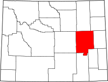 | |
| Towns | ||
| CDPs | ||
| Unincorporated communities | ||