Georgia State Route 32
| ||||
|---|---|---|---|---|
 | ||||
| Route information | ||||
| Maintained by GDOT | ||||
| Length: | 188.8 mi[1] (303.8 km) | |||
| Major junctions | ||||
| West end: |
| |||
|
| ||||
| East end: |
| |||
| Location | ||||
| Counties: | Terrell, Lee, Worth, Turner, Irwin, Coffee, Bacon, Pierce, Brantley, Glynn | |||
| Highway system | ||||
| ||||

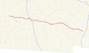
State Route 32 (SR 32) is a 188.8-mile-long (303.8 km) state highway that runs west-to-east through portions of Terrell, Lee, Worth, Turner, Irwin, Coffee, Bacon, Pierce, Brantley, and Glynn counties in the southern part of the U.S. state of Georgia. The route connects Dawson to Sterling, via Ashburn and Douglas.
Route description
Dawson to Sycamore
SR 32 begins at an intersection with SR 45/SR 520 in Dawson, within Terrell County. Approximately 3,500 feet (1,100 m) later, it meets the western terminus of SR 118 (Crawford Street NE). Then, it leaves town, heading east. On the eastern city limits is Chickasawhatchee Cemetery. Farther to the east is Bethel Cemetery. After the highway enters Lee County, it curves to the south-southeast. Then, it gradually curves to the southeast. Just before entering Leesburg, SR 32 curves to the northeast, crosses over Kinchafoonee Creek, and then curves to the east. In town, it intersects US 19 Bypass/SR 3 Bypass. The three highways travel concurrent to the southeast for just over 1,000 feet (300 m), to an intersection with US 19/SR 3 (Walnut Street). At this intersection, US 19 Bypass/SR 3 Bypass meet their southern terminus, and SR 32 travels to the north, concurrent with US 19/SR 3. At 4th Street East, SR 32 departs the concurrency to the east northeast. One block later, it meets the southern terminus of SR 195 (Leslie Highway). At this intersection, it turns to the south-southeast and curves to the east. Just before leaving town, the highway passes Leesburg Cemetery. Farther to the east, it crosses over Muckalee Creek. Then, it meets the northern terminus of SR 91 before crossing over the Flint River into Worth County. Just under 2 miles (3.2 km) into the county, it intersects SR 300 (Georgia–Florida Parkway). It curves southeast to an intersection with SR 313 in Doles. Continuing to the southeast, it intersects SR 33. Just over 0.5 miles (0.80 km) later, it enters Turner County. The route curves back to the northeast and enters Ashburn. In town, it intersects SR 112 (West Washington Street). The two routes begin a concurrency to the main part of town. At the intersection with US 41/SR 7, SR 112 continues to the northeast, while SR 32 turns right onto US 41/SR 7. The three routes head concurrent into Sycamore. Just outside Ashburn, they pass the Turner County Airport.[1]
Sycamore to Sterling
In Sycamore, SR 32 splits off to the east-northeast and immediately meets the eastern terminus of SR 32 Connector. Just to the east is an interchange with Interstate 75 (I-75). Then, it passes Pleasant Hill Cemetery and curves to the east. After that, it passes Bethel Cemetery and curves again to the southeast. Later on, it curves to the east-northeast and enters Irwin County a short distance later. SR 32 curves to the northeast and begins a concurrency with SR 125 (Waterloo Highway). The two highways head northeast over the Alapaha River, pass Burton Lake, Oak Grove Cemetery, and Brown Lake, before passing through Irwinville. At Hogan Lake, SR 32 departs to the southeast and travels into Ocilla. In the western part of town, it intersects US 319/SR 35. The three highways travel concurrent into the main part of town. They have an intersection with US 129/SR 11/SR 90 (Irwin Avenue). At this intersection, SR 35 reaches its northern terminus, while US 319 turns left onto US 129/SR 11/SR 90, and SR 32 continues to the east. Along its routing, it crosses over the Willacoochee River, curves to the east-southeast, and enters Coffee County. South-southwest of Ambrose, the highway has an intersection with both the northern terminus of SR 149 and the southern terminus of SR 268. SR 32 continues to the southeast, passing through rural areas of the county and enters Douglas. In town is an intersection with SR 206 (Bowens Mill Road). Then, it intersects US 441/SR 31 in the main part of town. Just before leaving town, it intersects US 221/SR 135 (Bowens Mill Road SE). About 3 miles (4.8 km) later, the highway passes General Coffee State Park and crosses over 17 Mile River. It travels through Nicholls and curves to the northeast into Bacon County. The highway heads northeast and curves to the east to enter Alma. There, it intersects SR 4 Alternate (Dixon Street). A few blocks later, in the main part of town, it intersects US 1/SR 4 (Pierce Street). The road passes one block north of Rose Hill Cemetery. The highway travels to the east and curves to the southeast just before intersecting SR 203 in New Lacy. The two routes have a very brief concurrency to the southeast. Continuing southeast, it enters Pierce County. SR 32 passes through Mershon and enters Bristol, where it intersects SR 15/SR 121. Farther to the southeast, in Patterson, is an intersection with US 84/SR 38. The route crosses over the Little Satilla River into Brantley County. In Hortense, it intersects US 301/SR 23, then proceeds to Needmore, where it meets the northern terminus of SR 110. It curves to the southeast and enters Glynn County. In Anguilla, it begins a concurrency with SR 99. The two routes curve to the northeast, curve back to the east, and enter Sterling. There, they intersect US 25/US 341/SR 27. At this intersection, SR 32 meets its eastern terminus, while SR 99 continues to the east.[1]
All of SR 32 is included as part of the National Highway System, a system of roadways important to the nation's economy, defense, and mobility.[2]
Major intersections
| County | Location | mi[1] | km | Destinations | Notes |
|---|---|---|---|---|---|
| Terrell | Dawson | 0.0 | 0.0 | Western terminus | |
| 0.7 | 1.1 | Western terminus of SR 118 | |||
| Lee | Leesburg | 17.8 | 28.6 | Western end of US 19 Bypass/SR 3 Bypass concurrency | |
| 18.4 | 29.6 | Eastern end of US 19 Bypass/SR 3 Bypass concurrency; western end of US 19/SR 3 concurrency | |||
| 19.2 | 30.9 | Eastern end of US 19/SR 3 concurrency | |||
| 19.3 | 31.1 | Southern terminus of SR 195 | |||
| | 26.8 | 43.1 | Northern terminus of SR 91 | ||
| Flint River | 28.4 | 45.7 | Unnamed bridge over the Flint River, marking the Lee–Worth county line | ||
| Worth | | 30.3 | 48.8 | ||
| Doles | 37.0 | 59.5 | |||
| | 42.0 | 67.6 | |||
| Turner | Ashburn | 51.3 | 82.6 | Western end of SR 112 concurrency | |
| 52.0 | 83.7 | Eastern end of SR 112 concurrency; western end of US 41/SR 7 concurrency | |||
| Sycamore | 55.0 | 88.5 | Eastern end of US 41/SR 7 concurrency | ||
| 55.1 | 88.7 | Eastern terminus of SR 32 Connector | |||
| | 56.5 | 90.9 | I-75, exit 78 | ||
| Irwin | | 68.3 | 109.9 | Western end of SR 125 concurrency | |
| Alapaha River | 68.6 | 110.4 | Unnamed bridge | Crossing over the Alapaha River | |
| | 72.8 | 117.2 | Eastern end of SR 125 concurrency | ||
| Ocilla | 79.6 | 128.1 | Western end of US 319 & SR 35 concurrencies | ||
| 80.2 | 129.1 | Eastern end of US 319 concurrency; northern terminus of SR 35 | |||
| Willacoochee River | 84.9 | 136.6 | Unnamed bridge | Crossing over the Willacoochee River | |
| Coffee | | 93.6 | 150.6 | Northern terminus of SR 149; southern terminus of SR 268 | |
| Douglas | 104 | 167 | Western terminus of SR 32 Truck | ||
| 105 | 169 | Southbound lanes of US 441/SR 31 on one-way pairs | |||
| 105 | 169 | Northbound lanes of US 441/SR 31 on one-way pairs | |||
| Western end of US 221 concurrency | |||||
| 106.2 | 170.9 | Eastern end of US 221 concurrency; Eastern terminus of SR 32 Truck | |||
| 17 Mile River | 110.9 | 178.5 | David Nipper Memorial Bridge | Crossing over the 17 Mile River | |
| Bacon | Alma | 128.1 | 206.2 | ||
| 128.5 | 206.8 | ||||
| New Lacy | 133.9 | 215.5 | Western end of SR 203 concurrency | ||
| | 134.1 | 215.8 | Eastern end of SR 203 concurrency | ||
| Pierce | Bristol | 145.5 | 234.2 | ||
| Patterson | 151.7 | 244.1 | |||
| Little Satilla River | 158.6 | 255.2 | Unnamed bridge over the Little Satilla River | ||
| Brantley | Hortense | 163.7 | 263.4 | ||
| Needmore | 166.6 | 268.1 | Northern terminus of SR 110 | ||
| Glynn | Anguilla | 185.9 | 299.2 | Western end of SR 99 concurrency | |
| Sterling | 188.8 | 303.8 | Eastern terminus; eastern end of SR 99 concurrency | ||
1.000 mi = 1.609 km; 1.000 km = 0.621 mi
| |||||
Bannered routes
Sycamore connector
| |
|---|---|
| Location: | Sycamore |
| Length: | 0.041 mi[3] (0.066 km) |

State Route 32 Connector (SR 32 Connector) is a 217-foot-long (66 m) connector route that exists entirely within the city limits of Sycamore, in the south-central part of Turner County.
It begins at an intersection with US 41/SR 7 (East Railroad Avenue). It travels in a northeasterly direction until it meets its eastern terminus, an intersection with the SR 32 mainline (Jefferson Davis Highway). Due to the format to the intersection of US 41/SR 7 and the SR 32 mainline, the route is an easier way for drivers to travel from US 41/SR 7 north to SR 32 east and from SR 32 west to US 41/SR 7 south.[3]
The entire route is in Sycamore, Turner County.
| mi[3] | km | Destinations | Notes | ||
|---|---|---|---|---|---|
| 0.000 | 0.000 | Western terminus | |||
| 0.041 | 0.066 | Eastern terminus | |||
| 1.000 mi = 1.609 km; 1.000 km = 0.621 mi | |||||
Douglas truck route
| |
|---|---|
| Location: | Douglas |
State Route 32 Truck (SR 32 Truck) is a truck route around Douglas, Georgia running south of mainline SR 32. It is named Bowens Mill Road Southwest, and Bowens Mill Road Southeast.
The route begins as it joins southbound Georgia State Route 206 and former Georgia State Route 353 running southwest. The first site it encounters is a bridge over a former Seaboard Coast Line Railroad line. Around the vicinity of a Wal-Mart distribution center, and before reaching the intersection with Thompson Drive it curves from southwest to southeast. At Georgia State Route 158, the route is joined by Georgia State Truck Route 158. Just before a local farm and ranch supply store, the routes curve towards the east before encountering Georgia State Route 135, which joins the overlap. All routes run along the north side of the Douglas Municipal Airport. SR 206 ends at US 221/441/SR 31, and US 221 joins the route, Just before reaching Brantley Boulevard the road starts to curve northeast. Truck Route 158 ends at SR 158, but US 221/Truck Route 32/SR 135 continues northeast. At a grade crossing with the same former Seaboard Coast Line Railroad line it previously went over, the routes encounter and intersection with Spooner Road and Iron Road, and then curves to the northwest. Georgia State Truck Route 32 finally ends at the east end of a short multiplex between US 221/SR 135 and SR 32.
See also
-
.svg.png) Georgia (U.S. state) portal
Georgia (U.S. state) portal -
 U.S. Roads portal
References
- 1 2 3 4 Google (August 18, 2013). "Route of SR 32 (Dawson to Douglas)" (Map). Google Maps. Google. Retrieved August 18, 2013.
Google (August 18, 2013). "Route of SR 32 (Douglas to Sterling)" (Map). Google Maps. Google. Retrieved August 18, 2013. - ↑ "National Highway System: Georgia" (PDF). United States Department of Transportation. October 1, 2012. Retrieved August 18, 2013.
- 1 2 3 Google (August 18, 2013). "Route of SR 32 Connector" (Map). Google Maps. Google. Retrieved August 18, 2013.
External links
-
 Media related to Georgia State Route 32 at Wikimedia Commons
 - Georgia Roads (Routes 21 - 40)
- Georgia State Route 32 on State-Ends.com