Richland, Georgia
| Richland, Georgia | |
|---|---|
| City | |
 | |
 Location in Stewart County and the state of Georgia | |
| Coordinates: 32°5′19″N 84°39′50″W / 32.08861°N 84.66389°WCoordinates: 32°5′19″N 84°39′50″W / 32.08861°N 84.66389°W | |
| Country | United States |
| State | Georgia |
| County | Stewart |
| Area | |
| • Total | 4.2 sq mi (10.8 km2) |
| • Land | 4.2 sq mi (10.8 km2) |
| • Water | 0 sq mi (0 km2) |
| Elevation | 607 ft (185 m) |
| Population (2000) | |
| • Total | 1,794 |
| • Density | 427.1/sq mi (166.1/km2) |
| Time zone | Eastern (EST) (UTC-5) |
| • Summer (DST) | EDT (UTC-4) |
| ZIP code | 31825 |
| Area code(s) | 229 |
| FIPS code | 13-65016[1] |
| GNIS feature ID | 0356496[2] |
Richland is a city in Stewart County, Georgia, United States. The population was 1,794 at the 2000 census.
Geography
Richland is located along U.S. Route 280 and Georgia State Route 520 (known as South Georgia Parkway). U.S. Route 280 and Georgia 520 lead northwest 36 miles (58 km) to Columbus. The two highways separate in the city, with U.S. Route 280 leading east 29 miles (47 km) to Americus and Georgia 520 leading southeast 52 miles (84 km) to Albany.
According to the United States Census Bureau, the city has a total area of 4.2 square miles (11 km2), of which, 4.2 square miles (11 km2) of it is land and 0.04 square miles (0.10 km2) of it (0.48%) is water.
Demographics
| Historical population | |||
|---|---|---|---|
| Census | Pop. | %± | |
| 1890 | 457 | — | |
| 1900 | 1,014 | 121.9% | |
| 1910 | 1,250 | 23.3% | |
| 1920 | 1,529 | 22.3% | |
| 1930 | 1,577 | 3.1% | |
| 1940 | 1,497 | −5.1% | |
| 1950 | 1,571 | 4.9% | |
| 1960 | 1,472 | −6.3% | |
| 1970 | 1,823 | 23.8% | |
| 1980 | 1,802 | −1.2% | |
| 1990 | 1,668 | −7.4% | |
| 2000 | 1,794 | 7.6% | |
| 2010 | 1,473 | −17.9% | |
| Est. 2015 | 1,496 | [3] | 1.6% |
As of the census[1] of 2000, there were 1,794 people, 624 households, and 413 families residing in the city. The population density was 429.3 people per square mile (165.7/km²). There were 716 housing units at an average density of 171.3 per square mile (66.1/km²). The racial makeup of the city was 62.54% African American, 35.95% White, 0.11% Native American, 0.22% from other races, and 1.17% from two or more races. Hispanic or Latino of any race were 2.73% of the population.
There were 624 households out of which 29.8% had children under the age of 18 living with them, 35.6% were married couples living together, 27.2% had a female householder with no husband present, and 33.8% were non-families. 30.4% of all households were made up of individuals and 15.2% had someone living alone who was 65 years of age or older. The average household size was 2.51 and the average family size was 3.15.
In the city the population was spread out with 24.1% under the age of 18, 8.2% from 18 to 24, 24.4% from 25 to 44, 21.3% from 45 to 64, and 22.0% who were 65 years of age or older. The median age was 40 years. For every 100 females there were 85.1 males. For every 100 females age 18 and over, there were 80.2 males.
The median income for a household in the city was $24,597, and the median income for a family was $29,423. Males had a median income of $26,313 versus $17,269 for females. The per capita income for the city was $14,127. About 17.3% of families and 23.8% of the population were below the poverty line, including 30.1% of those under age 18 and 25.8% of those age 65 or over.
References
- 1 2 "American FactFinder". United States Census Bureau. Retrieved 2008-01-31.
- ↑ "US Board on Geographic Names". United States Geological Survey. 2007-10-25. Retrieved 2008-01-31.
- ↑ "Annual Estimates of the Resident Population for Incorporated Places: April 1, 2010 to July 1, 2015". Retrieved July 2, 2016.
- ↑ "Census of Population and Housing". Census.gov. Archived from the original on May 11, 2015. Retrieved June 4, 2015.
Gallery
_(c._1890)_(Richland%2C_GA).JPG) Built in the 1890s and renovated in 2008, the Richland Depot now serves as the city hall. The building was listed on the National Register of Historic Places as a contributing property to the Richland Historic District on May 5, 1986.
Built in the 1890s and renovated in 2008, the Richland Depot now serves as the city hall. The building was listed on the National Register of Historic Places as a contributing property to the Richland Historic District on May 5, 1986..JPG) Richland Post Office (ZIP code: 31825)
Richland Post Office (ZIP code: 31825)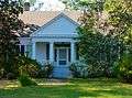 East of Richland, the Nathaniel Prothro Plantation was the largest cotton plantation in Stewart County at the beginning of the Civil War. The Greek Revival main house was built by 1851 by Dan E. Ponder. It was listed on the National Register of Historic Places on May 2, 1985.
.JPG) The Dr. Thomas B. Miller House was listed on the National Register of Historic Places on March 2, 1988
The Dr. Thomas B. Miller House was listed on the National Register of Historic Places on March 2, 1988 Bessie Lillian Gordy Carter, mother of Jimmy Carter, 39th President of the United States, was born and raised in Richland.
-Steve Sanders, Child actor,Southern gospel singer, and musician and baritone singer for the Oak Ridge Boys after William Lee Golden left the group, was from Richland, Ga.
- Jarvis Jones, professional football player with the Pittsburgh Steelers, was born in Richland.
Municipalities and communities of Stewart County, Georgia, United States | ||
|---|---|---|
| Cities | 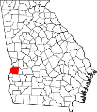 | |
| Unincorporated communities | ||