Fernbridge (bridge)
| Fernbridge | |
|---|---|
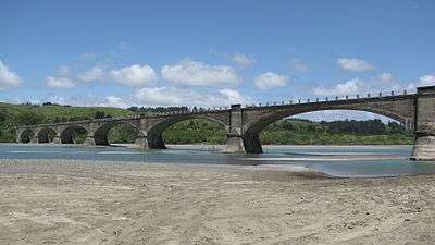 A view of the west side of Fernbridge from the south bank of the Eel River | |
| Carries |
|
| Crosses | Eel River |
| Locale | Fernbridge, California |
| Maintained by | California Department of Transportation |
| Characteristics | |
| Design | Arch bridge |
| Material | Concrete |
| Total length | 1,320 ft (402.3 m) |
| History | |
| Designer | John B. Leonard |
| Construction begin | 1910 |
| Opened | November 8, 1911 |
|
Fernbridge | |
  Location in California | |
| Coordinates | 40°36′51″N 124°12′8″W / 40.61417°N 124.20222°WCoordinates: 40°36′51″N 124°12′8″W / 40.61417°N 124.20222°W |
| Area | 1.4 acres (0.6 ha) |
| NRHP Reference # | 87000566[1] |
| Added to NRHP | April 2, 1987 |
Fernbridge is a 1,320-foot-long (402.3 m) concrete arch bridge designed by American engineer John B. Leonard which opened in 1911 at the site of an earlier ferry crossing of the Eel River. Fernbridge is the last crossing before the Eel arrives at the Pacific Ocean, and anchors one end of California State Route 211 leading to Ferndale, California. When built, it was named the "Queen of Bridges" and is still the longest, functional poured concrete bridge in operation in the world.[2]
Construction
After 17 years of petitioning by residents of Ferndale and the Eel River valley, Humboldt County Supervisors accepted bids for construction in 1910, and work started March 20 of that year.[3] Reinforced concrete was used because studies after the 1906 San Francisco earthquake along 296 miles (476 km) of the San Andreas Fault from Ferndale south to San Jose, California showed that reinforced concrete withstood earthquakes. The nearly one-quarter-mile (0.4 km) span cost US$245,967 (equivalent to $6,257,000 in 2015) to build, and consumed millions of board feet of local redwood timber for the framing. Construction was finished and the bridge put into operation on November 8, 1911.[3][4] As completed, the bridge had wooden trestle approach spans 500 feet (150 m) and 551 feet (168 m) long. The reinforced concrete structure was 1,451 feet (442 m) long overall with a 24-foot (7.3 m) wide roadway carried on seven 180-foot (55 m) long arches.[3] The original wooden approaches were replaced with the current concrete ramps in 1920.[5]
Floods
The bridge survived floods in 1912, 1913, 1914, 1915, 1937, 1953, 1955, 1964 and 1986.[4] In the 1955 Christmas Week flood, the flood waters measured 27.7 feet (8.4 m) deep at Fernbridge. The south side abutment was washed out, and the approach damaged.[4] During repairs the first end span was removed and an earthen embankment was built which shortened the bridge by about 20 feet (6.1 m).[4]
Nine years later during the Christmas flood of 1964, every stream gauge on the Eel River was either inundated and useless or destroyed except the one at Fernbridge and nearly every bridge on the Eel River was badly damaged because the force of the water was aided by thousands of redwood logs stacked for winter mill production along the bank of the river as well as homes and barns swept away by the rapidly rising waters.[6] The flood peak at Fernbridge occurred at 4:00 a.m. on December 23 when the flood level was 29.5 feet (9.0 m).[6] The waters stayed high for 24 hours, and the discharge was estimated to be in excess of 800,000 cubic feet per second (20,000 m3/s).[6] A large island which had built itself upstream of the bridge was washed away in the wake of the 1964 floods.[4]
Historic designation
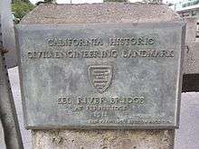
On September 24, 1976, the American Society of Civil Engineers designated Fernbridge as an historic civil engineering landmark and installed a plaque on the northwest approach pylon to the bridge.[7]
In 1987, the California Department of Transportation (Caltrans) recommended studying the removal of Fernbridge and replacement with a more modern span, such as the many which have washed into the Eel River during floods which Fernbridge withstood.[8] The Eel River regularly floods Fernbridge to the tops of the lower ridge of the support. In some high flood years, photographs have been taken showing the water level over the upper cone-shaped tops of the support pillars[9] as well as valley-wide flooding in 1915.[10] Residents of Ferndale campaigned to stop any changes to the historic bridge and Fernbridge was added to the National Register of Historic Places on April 2, 1987.[1]
Recent events
In 1995, Fernbridge served as the set for scenes in the movie Outbreak, where a string of U.S. Army tanks rolls across the bridge accompanied by low-flying assault helicopters. In 2008, Caltrans initiated restoration of the railings of Fernbridge to their original appearance. Additional small improvements were made in 2008 and 2009, but Fernbridge's general appearance remains unchanged.
_-_01.jpg)
For the 100th anniversary celebration on August 7, 2011, a ceremony was held, the bridge was officially closed to cross vehicular traffic,[11] a run over and back was held as was done on opening day in 1911, a parade of historic vehicles and local dignitaries crossed over, and a Ferndale resident borrowed construction lights and lit up Fernbridge at night.[12]
The United States Geological Survey maintains a live webcam at Fernbridge near their stream gauge to visually monitor stream conditions.[13]
References
- 1 2 National Park Service (2009-03-13). "National Register Information System". National Register of Historic Places. National Park Service.
- ↑ "California 211". AA Roads. Retrieved December 24, 2012.
- 1 2 3 "World's Biggest Concrete Bridge Opened at Weeott". San Francisco Call. 110 (174). 21 November 1911. Retrieved 31 August 2016.
- 1 2 3 4 5 Tuttle, Donald C. (June 10, 2011). A brief history of Fernbridge (PDF) (Report). Eureka, California: Humboldt County, California. p. 8. Retrieved December 24, 2012.
- ↑ The Ferndale Museum (2004). Carol, Bess; Newman, Beryl; Roberts, Ann, eds. Images of America: Ferndale. Charleston, South Carolina: Arcadia Publishing. p. 128. ISBN 978-0-7385-2890-8. Retrieved 31 August 2016.
- 1 2 3 Flood! December 1964–January 1965 (Report). State of California, Department of Water Resources. January 1965. Retrieved December 24, 2012. Bulletin No. 161, 43 pages plus appendices and charts
- ↑ Myers, William A.; American Society of Civil Engineers. San Francisco Section. History and Heritage Committee (1977). Historic civil engineering landmarks. San Francisco: Pacific Gas and Electric Co. p. 52. OCLC 6807860.
- ↑ Stein, Mark A. (March 13, 1987). "Pride of Ferndale: Townsfolk Fight to Save 75-Year-Old Bridge". Los Angeles Times. Retrieved December 24, 2012.
- ↑ "Fernbridge, photos 98, 99 & 100". Sunny Fortuna. Retrieved December 24, 2012.
- ↑ "Lynette's NorCal History Blog". 2012. Retrieved December 24, 2012.
- ↑ "Resolution Authorizing Temporary Closure of Vehicle Traffic Across the Bridge in Fernbridge, CA on August 7th, 2011 for the 100th Anniversary Celebration of the Bridge.". Minutes. Humboldt County Board of Supervisors. December 7, 2010. Retrieved December 24, 2012.
- ↑ "Fernbridge". Local Gallery. Aesthetic Design. August 7, 2011. Retrieved December 24, 2012.
- ↑ "Eel River At Fernbridge, California". USGS Webcam. United States Geological Survey. Retrieved December 24, 2012.
| Topics | |
|---|---|
| Lists by states |
|
| Lists by insular areas | |
| Lists by associated states | |
| Other areas | |
| |
