Fruitland, California
Coordinates: 40°17′45″N 123°49′31″W / 40.29583°N 123.82528°W
| Fruitland | |
|---|---|
| Unincorporated community | |
|
Fruitland  Fruitland Location in California | |
| Coordinates: 40°17′45″N 123°49′31″W / 40.29583°N 123.82528°W | |
| Country | United States |
| State | California |
| County | Humboldt County |
| Elevation[1] | 1,004 ft (306 m) |
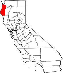
Fruitland (formerly Elk Prairie)[2] is an unincorporated community in Humboldt County, California.[1] It is located 6 miles (10 kilometers) east-southeast of Weott,[2] at an elevation of 1,004 feet (306 m).[1]
A post office operated at Fruitland from 1890 to 1934.[2] The first settlers of Fruitland were a colony of immigrants from the Netherlands who planted orchards[2] sponsored by David Page Cutten, the namesake of Cutten, CA, approximately 37 mi (60 km) northwest of Fruitland. The isolation of this colony in a time when there was little adequate long-distance transportation ultimately led to the dissolution of the colony's fruit market.[3]
References
- 1 2 3 U.S. Geological Survey Geographic Names Information System: Fruitland, California
- 1 2 3 4 Durham, David L. (1998). California's Geographic Names: A Gazetteer of Historic and Modern Names of the State. Clovis, Calif.: Word Dancer Press. p. 64. ISBN 1-884995-14-4.
- ↑ Turner, Dennis W.; Turner, Gloria H. (2010). Place Names of Humboldt County, California (2nd ed.). Orangevale, CA: Dennis W. & Gloria H. Turner. p. 104. ISBN 978-0-9629617-2-4.
This article is issued from Wikipedia - version of the 11/28/2016. The text is available under the Creative Commons Attribution/Share Alike but additional terms may apply for the media files.
