Enchanted Rock
| Enchanted Rock | |
|---|---|
 Enchanted Rock, as seen from the trail leading to its summit on a busy hiking day. | |
| Highest point | |
| Elevation | 1,825 ft (556 m) [1] |
| Coordinates | 30°30′24″N 98°49′08″W / 30.5065789°N 98.8189305°WCoordinates: 30°30′24″N 98°49′08″W / 30.5065789°N 98.8189305°W [2] |
| Geography | |
 Enchanted Rock Texas | |
| Location | Llano County, Texas, US |
| Geology | |
| Mountain type | granite dome |
| Designated | 1971 |
Enchanted Rock (16710 Ranch Rd 965, Fredericksburg TX) is an enormous pink granite pluton batholith located in the Llano Uplift approximately 17 miles (27 km) north of Fredericksburg, Texas and 24 miles (39 km) south of Llano, Texas, United States. Enchanted Rock State Natural Area, which includes Enchanted Rock and surrounding land, spans the border between Gillespie County and Llano County, south of the Llano River. Enchanted Rock covers approximately 640 acres (260 ha) and rises approximately 425 feet (130 m) above the surrounding terrain to elevation of 1,825 feet (556 m) above sea level. It is the largest such pink granite monadnock in the United States. Enchanted Rock State Natural Area, a part of the Texas state park system, includes 1,644 acres (665 ha).[3] Designated a Recorded Texas Historic Landmark in 1936.[4]
Geology
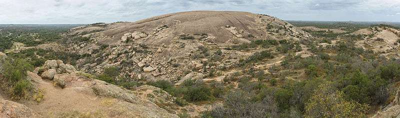


The prominent granite dome is visible for many miles in the surrounding basin of the Llano Uplift. The weathered dome, standing above the surrounding plain is known to geologists as a monadnock. The rock is actually the visible above-ground part of a segmented ridge, the surface expression of a large igneous batholith, called the Town Mountain Granite[5] of middle Precambrian (1,082 ± 6 million years ago)[6] material that intruded into earlier metamorphic schist, called the Packsaddle Schist.[5] The intrusive granite of the rock mass, or pluton, was exposed by extensive erosion of the surrounding sedimentary rock, primarily the Cretaceous Edwards limestone, which is exposed a few miles to the south of Enchanted Rock.[5]
History

| Timeline of Enchanted Rock History [7][8] | ||
|---|---|---|
| Date | Event | |
| 1838 |
| |
| 1841 |
| |
| 1844 |
| |
| 1880–1881 |
| |
| 1886 |
| |
| 1895 |
| |
| 1927 |
| |
| 1946 |
| |
| 1970 |
| |
| 1978 |
| |
| 1984 |
| |
Archaeological evidence indicates human visitation at the rock going back at least 11,000 years.
According to the book [10] The Enchanted Rock published in 1999 by Ira Kennedy [11][12]
These hunter-gatherers had flint-tipped spears, fire, and stories. With these resources, some twelve thousand years ago, the first Texans became the wellspring of Plains Indian culture. On the basis of archaeological evidence, human habitation at Enchanted Rock can be traced back at least 10,000 years. Paleo-Indian projectile points, or arrowheads, 11–12,000 years old have been found in the area upstream and downstream from The Rock. The oldest authenticated projectile point found within the present day park is a Plainview point type, dating back 10,000 years.
The rock has been the subject of numerous geological surveys and paintings.
Legends and Mysticism
Folklore of local Tonkawa, Apache and Comanche tribes ascribes magical and spiritual powers to the rock (hence the name 'Enchanted Rock'). While attempting to hide from Anglo settlers in the area, the natives would hide on the top two tiers of the rock, where they were invisible from the ground below. The first European to visit the area was probably Álvar Núñez Cabeza de Vaca in 1536. The Tonkawa, who inhabited the area in the 16th century, believed that ghost fires flickered at the top of the dome. In particular they heard unexplained creaking and groaning, which geologists attribute to the rock's night-time contraction after being heated by the sun during the day. The name "Enchanted Rock" derives from Spanish and Anglo-Texan interpretations of such legends and related folklore; the name "Crying Rock" has also been given to the formation.
A plaque formerly embedded in Enchanted Rock near the top, but now removed to a kiosk below, reads:[13]
From its summit in 1841, Captain John C. Hays, while surrounded by Comanche Indians who cut him off from his ranging company repulsed the whole band and inflicted upon them such heavy losses that they fled.
Marked by the State of Texas 1936
Other legends [14] [15] associated with Enchanted Rock are
- Named “Spirit Song Rock” for native legends
- Revered by native tribes as a holy portal to other worlds
- Anyone spending the night on the rock becomes invisible
- Spanish priest fled to the rock pursued by native tribes, disappeared, and returned to tell a mystic tale of falling into a cavern and being swallowed by the rock, encountering many spirits in the tunnels, eventually to be spit out two days later
- Haunted by spirits of warriors of a now-extinct Native American tribe who were slaughtered at Enchanted Rock by a rival tribe
- Haunted by a Native American princess who threw herself off the rock after witnessing the slaughter of her people
- Alleged sacrifices at the rock by both Comanche and Tonkawa tribes
- Believed to be a lost silver mine, or the lost El Dorado gold
- Bad fortune and death will befall anyone who climbs the rock with bad intent
- Footprint indentations on the rock of Native American chief who sacrificed his daughter, condemned to walk Enchanted Rock forever
- Woman’s screams at night are of a white woman who took refuge on Enchanted Rock after escaping a kidnapping by Native Americans
- Spanish soldier Don Jesús Navarro’s Enchanted Rock rescue of native maiden Rosa, daughter of Chief Tehuan, after her kidnap by Comanches intent on sacrificing her on the rock
Flora and fauna


More than 500 species of plants,[16] from four chief Plant Communities — Open Oak Woodland, Mesquite Grassland, Floodplain, and Granite Rock Community — inhabit the rock. Vernal pools, ecologically threatened depressions of flora and fauna adapted to harsh environments, contain fragile invertebrate fairy shrimp. Other wildlife includes bats, ringtails, squirrels, and fox. A wide variety of lizards, including the Texas Horned Lizard also make the Enchanted Rock area their home.
Designated a key bird watching site,[17] bird enthusiasts can observe wild turkey, greater roadrunner, golden-fronted woodpecker, Woodhouse's scrub jay, canyon towhee, rufous-crowned sparrow and black-throated sparrow, lesser goldfinch, common poorwill, chuck-will's-widow, black-chinned hummingbird, vermilion flycatcher, scissor-tailed flycatcher, Bell's vireo and yellow-throated vireo, blue grosbeak, painted bunting, orchard oriole, vesper sparrow, fox sparrow, Harris's sparrow and Lark sparrow.
Enchanted Rock State Natural Area and Conservation


Park activities include caving,[18] hiking, primitive backpack camping, rock climbing and picnicking. The Summit Trail[19] is the most popular hiking path.
Emphasis is placed on activity safety and ecological preservation. Visitors are asked to keep human incursion at a minimum by not disturbing plants, animals or artifacts.[20]
Federal and state statutes, regulations and rules governing archeological and historic sites apply.[21] The state Game Warden as a commissioned peace officer is authorized to inspect natural resources and take any necessary action for the preservation of the resources.[22] As of March 1st, 2016, dogs are not allowed on the summit trail anymore.
Texas Parks and Wildlife Department partners with Friends of Enchanted Rock,[23] a volunteer-based nonprofit organization that works for the improvement and preservation of Enchanted Rock State Natural Area. Scheduled Summit Trail tours are the third Saturday of the month starting April, May, September, October, November, and December. Private tours are available for groups at other times.
Gallery
-
View of Enchanted Rock from base camp
-

Little Rock View
-

Enchanted Rock view from the top
-
Little Rock View 1
-
Enchanted Rock back-face caves
-
View from the top of enchanted rock facing park entrance
-

View from halfway down Enchanted Rock
-
View of Enchanted Rock from base camp
-

Enchanted Rock State Natural Area main trailhead sign, 10 Aug 2013.
-

Enchanted Rock in 1912, showing exfoliation of the granite parallel to the surface.[1]
-

Enchanted Rock aerial view in Sept. 2008.
-

A view of distant rain clouds, from atop Enchanted Rock in July 2008.
-

Turkey Peak, Enchanted Rock State Natural Area, 10 Aug 2013.
-

Historical marker fixed at Enchanted Rock in 1956 (photo from 1980).
- ^ Paige, S. 1912. Llano-Burnet folio, Texas. United States Department of the Interior, U.S. Geological Survey, Folios of the Geologic Atlas, No. 183, 16 pp. (See Plate 10)
See also
- Albert, Texas
- Cherry Springs Dance Hall
- Doss, Texas
- Easter Fire
- Fredericksburg, Texas
- Harper, Texas
- Luckenbach, Texas
- Spy Rock
- Stonewall, Texas
- Texas Hill Country
References
- ↑ "Enchanted Rock, Texas". Peakbagger.com. Retrieved 2012-12-27.
- ↑ "Enchanted Rock". Geographic Names Information System. United States Geological Survey. Retrieved 2012-12-27.
- ↑ "State Natural Area, Enchanted Rock". Texas Parks and Wildlife Dept. Retrieved 6 May 2010. Texas Parks and Wildlife Dept
- ↑ "Enchanted Rock". Texas Historic Markers. William Nienke, Sam Morrow. Retrieved 25 January 2011.
- 1 2 3 University of Texas at Austin, Bureau of Economic Geology, Barnes, V.E., Hartmann, Barbara and Scranton, D.F., 1992, Geologic map of Texas: University of Texas at Austin, Bureau of Economic Geology, scale 1:500000.
- ↑ Walker, Nicholas, Middle Proterozoic geologic evolution of Llano uplift, Texas: Evidence from U-Pb zircon geochronometry, Geological Society of America Bulletin 1992;104;494–504
- ↑ Kohout, Martin Donell: State Natural Area, Enchanted Rock from the Handbook of Texas Online. Retrieved 06 May 2010. Texas State Historical Association
- ↑ "History, Enchanted Rock State Natural Area". Texas Parks and Wildlife Dept. Retrieved 6 May 2010. Texas Parks and Wildlife Dept
- ↑ "National Landmark, Enchanted Rock". National Park Service. Retrieved 6 May 2010. National Park Service
- ↑ "History, The Enchanted Rock". TexFiles. Retrieved 6 May 2010. TexFiles
- ↑ "Kennedy, Ira – Bio". TexFiles. Retrieved 6 May 2010. TexFiles
- ↑ "Kennedy, Ira – Articles". TexFiles. Retrieved 6 May 2010. TexFiles
- ↑ "Hays, John C. – Plaque". Alison Chains – Flickr. Retrieved 6 May 2010.
- ↑ Kohout, Martin Donell: Legends, Enchanted Rock from the Handbook of Texas Online. Retrieved 06 May 2010. Texas State Historical Association
- ↑ "Legends & History of Sacred Enchanted Rock". Scribd. Retrieved 6 May 2010. Texas Tourism Press
- ↑ "Photo Experience and Plant Life, Enchanted Rock". Enchanted Rock State Natural Area. Retrieved 6 May 2010. Enchanted Rock State Natural Area
- ↑ "Bird Watching Sites, Enchanted Rock State Natural Area". Trails.com. Retrieved 6 May 2010. Trails.com
- ↑ "Caving at Enchanted Rock State Park (a video tour)". Morning Star Productions. Retrieved 6 May 2010. Morning Star Productions
- ↑ "Summit Trail, Enchanted Rock". Austin Explorer. Retrieved 6 May 2010. Barron, Robert
- ↑ "Information Brochure, Enchanted Rock State Natural Area" (PDF). Texas Parks and Wildlife Dept. Retrieved 6 May 2010. Texas Parks and Wildlife Dept
- ↑ "Federal-State statutes, regulations, rules". Texas Historical Commission. Retrieved 6 January 2012.
- ↑ "Game Warden". Texas Parks and Wildlife. Retrieved 6 January 2012.
- ↑ "Friends of Enchanted Rock". Friends of Enchanted Rock. Retrieved 29 Sep 2010.
Additional reading
- Dobie, J Frank; Estill, Julia (1995). "The Enchanted Rock in Llano County". Legends of Texas: Volume II: Pirates' Gold and Other Tales. Pelican Publishing. pp. 78–82. ISBN 978-1-56554-073-6.
- Allred, Lance (2009). Enchanted Rock: A Natural and Human History. University of Texas Press. ISBN 978-0-292-71963-7.
- Moore, Stephen L (2007). "Enchanted Rock and Bird's Fort". Savage Frontier: 1840–1841: Rangers, Riflemen, and Indian Wars in Texas. University of North Texas Press. ISBN 978-1-57441-228-4.
External links
| Wikimedia Commons has media related to Enchanted Rock. |
- Enchanted Rock State Natural Area
- Enchanted Rock from the Handbook of Texas Online
- E-Rock: Virtual Trip to Enchanted Rock
- Technical rock climbing at Enchanted Rock


| Central city |  | ||||||
|---|---|---|---|---|---|---|---|
| Satellite cities | |||||||
| Other communities | |||||||
| Counties |
| ||||||
| Parks and preserves |
| ||||||
| Geography | |||||||
| Bodies of water | |||||||
| Transportation | |||||||