McClellan Creek National Grassland
| McClellan Creek National Grassland | |
|---|---|
|
IUCN category VI (protected area with sustainable use of natural resources) | |
|
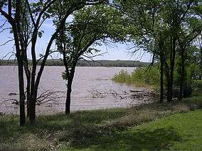
Lake McClellan | |
 | |
| Location | Gray County, Texas, United States |
| Nearest city | Alanreed, TX |
| Coordinates | 35°12′39″N 100°52′08″W / 35.2107°N 100.8689°WCoordinates: 35°12′39″N 100°52′08″W / 35.2107°N 100.8689°W |
| Area | 1,449 acres (5.86 km2) |
| Governing body | U.S. Forest Service |
| Website | Black Kettle and McClellan Creek National Grasslands |
McClellan Creek National Grassland is a National Grassland located in southern Gray County, Texas, United States. It was purchased with the goal of restoring badly eroded land to its natural state. The grassland is administered by the U.S. Forest Service together with Cibola National Forest and Black Kettle, Kiowa, and Rita Blanca National Grasslands, from common headquarters located in Albuquerque, New Mexico.[1] The grassland is part of the combined Black Kettle and McClellan Creek Ranger District with offices in Cheyenne, Oklahoma.
In February 2006, all of McClellan Creek National Grassland was burnt out in the 750,000-acre (300,000 ha) Interstate 40 fire. The majority of the trees were lost.[2] The grassland's area is only 1,449 acres (586 ha).[3] The grasslands surrounds McClellan Lake, a reservoir on the namesake McClellan Creek.[4]
._-_NARA_-_533046.tif.jpg) Frank Baldwin's charge on Grey Beard's Band, McClellan's Creek, TX, Nov. 8, 1874
Frank Baldwin's charge on Grey Beard's Band, McClellan's Creek, TX, Nov. 8, 1874 McClellan Creek National Grassland after the 2006 fire
References
- ↑ "Cibola National Forest and National Grasslands". U.S. Forest Service. Retrieved December 8, 2012.
- ↑ "The Lone Tree Exhibit". U.S. Forest Service. Retrieved December 8, 2012.
- ↑ "Land Areas of the National Forest System". U.S. Forest Service. January 2013. Retrieved December 8, 2012.
- ↑ "Windmills on the National Grasslands". U.S. Forest Service. Retrieved December 8, 2012.
External links
 Media related to McClellan Creek National Grassland at Wikimedia Commons
- Black Kettle and McClellan Creek National Grasslands