Mount Bonnell
|
Covert Park at Mount Bonnell | |
|
View of Lake Austin from the summit of Mount Bonnell | |
 Mount Bonnell  Mount Bonnell | |
| Location |
3800 Mount Bonnell Rd Austin, Texas 78731 |
|---|---|
| Coordinates | 30°19′16″N 97°46′25″W / 30.3210°N 97.7736°WCoordinates: 30°19′16″N 97°46′25″W / 30.3210°N 97.7736°W |
| Area | 5.36 acres (2.17 ha) |
| Built | June 2, 1939 |
| NRHP Reference # | 15000619 |
| RTHL # | 6473 |
| Significant dates | |
| Added to NRHP | September 17, 2015 |
| Designated RTHL | 1969 |
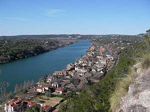
Mount Bonnell /bəˈnɛl/, also known as Covert Park, is a prominent point alongside the Lake Austin portion of the Colorado River in Austin, Texas. It has been a popular tourist destination since the 1850s.[1][2] The mount provides a vista for viewing the city of Austin, Lake Austin, and the surrounding hills.[3] It was designated a Recorded Texas Historic Landmark in 1969, bearing Marker number 6473,[4] and was listed on the National Register of Historic Places in 2015.
Geography
Mount Bonnell is located at 30.3210°N, 97.7736°W (WGS 84 datum). Although the mount is often described as the highest point in Austin, the elevation at its peak (about 780 feet above mean sea level (AMSL)) is less than that of the Jollyville Plateau (max. elevation about 1100 feet AMSL ).
History
Mount Bonnell's Indian Trail
A historical marker was placed at Mount Bonnell in 1969 by State Historical Survey Committee.[5] The marker reads:
Rising 775 feet above sea level, this limestone height was named for George W. Bonnell, who came to Texas with others to fight for Texas independence, 1836. Was commissioner of Indian affairs in Republic of Texas under President Sam Houston. Moved in 1839 to Austin; there published the "Texas Sentinel", 1840. Member Texan-Santa Fe expedition, 1841. Was captured but released in time to join Mier expedition, 1842. Was killed in camp on Rio Grande, Dec, 26, 1842. Frontiersman W.A.A. "Bigfoot" Wallace killed an Indian he met face to face while crossing a narrow ledge 50 feet above river, 1839. He also took refuge in a Mount Bonnell cave to recover from "flux", but was missing so long his sweetheart eloped. In the mid-1800s Mormons built a mill on the Colorado river at foot of Mount Bonnell. Mill was destroyed by flood and the Mormons moved on west. Mount Bonnell was site of picnics and outings in 1850s and 1860s. As it is today. Legend has it that an excursion to the place in the 1850s inspired the popular song "Wait for the Wagon and We'll All Take a Ride". As a stunt in 1898, Miss Hazel Keyes slid down a cable stretched from the top of Mount Bonnell to south bank of then Lake McDonald below.
Years after Bigfoot Wallace's refuge in the cave on Mount Bonnell, when asked why he had chosen the cave as a refuge, he responded "Well .. the cave was right on the old Indian trail leading down to Austin, and I thought I would be able to keep my hand in by 'upping' one now and then; and besides, the cave was in the best hunting ground for bear in all this country.."[6]
Julia Lee Sinks, author and historian, was an early settler to Austin, arriving in the spring of 1840. Before meeting and marrying George Sinks, chief clerk of the Post Office Department during the Republic years, she lived on West Pecan, present day 6th street, and later wrote “Our home was on the beaten track of the Indians into town from the pass of Mount Bonnell. The knolls beyond the quarry branch were interspersed with timber, and sometimes though not often, we would see galloping past the open spaces beyond the blanketed Indian. The path along the quarry branch, secluded as it was, became their main inlet to the town. It was a sheltered road, never traveled at night by whites, so the Indians claimed right of way, and all full moons brought moccasin tracks in abundance”.[7]
If Mount Bonnell was on an Indian trail into Austin, it was also a trail out, as illustrated in another story included in Wilbarger’s book, Indian Depredations of Texas. In 1842, a Mrs. Simpson living on that very same street as Julia Lee Sinks, West Pecan, about three blocks west of Congress, had two children – a daughter 14, a son 12—abducted by Indians while the children were in the adjacent “valley” (Shoal Creek). Wilbarger says that at that time there were no houses there. The Indians “seized the children, mounted their horses and made off for the mountains .. going in the direction of Mt. Bonnell”. A posse was raised and gave pursuit. Wilbarger then says “At one time the citizens came within sight of the redskins just before reaching Mt. Bonnell, but the Indians, after arriving at the place, passed on just beyond to the top of the mountain, which being rocky, the citizens lost the trail and were never able to find where the savages went down the mountain”. The Simpson girl was killed, but the boy survived and was later “traded off to some Indian traders, who returned him to his mother”. It is because the boy survived and was returned home that we know what happened after the posse lost the trail of the Indians on Mount Bonnell. From Mt. Bonnell they stopped at Spicewood Springs, “which is situated in the edge of the mountains”. This is where the Simpson girl was killed.[8] Spicewood Springs is located about 5 miles north of Mount Bonnell, at the present day intersections of Mopac Expressway and Spicewood Springs Road.
Origin of the name
Mount Bonnell is generally believed to have been named after early Texas newspaper publisher George W. Bonnell,[9] who moved to Texas in 1836. George W. Bonnell was publisher of the local paper The Texas Sentinel and was prominent in early Texas and Travis County (Austin) affairs after the War for Independence.[10] Though sources have long credited George Bonnell as the mountain’s namesake, Albert Sidney Johnston[11] may have named Mount Bonnell in present-day Austin for his friend and fellow West Point graduate Joseph Bonnell,[10][12] who was a Captain in the Texas Army during the War for Independence.[13] There is little contemporaneous evidence to support either derivation of the name.
Legend has it that Mount Bonnell was once called Antoinette's Leap, after a young woman who leaped to her death to avoid being captured by Native Americans who had killed her fiancé.[9]
Geology
Mt. Bonnell forms part of the Balcones Fault Escarpment and these "balconies" were first described by Bernardo de Miranda in 1756.[14] The lower Cretaceous Glen Rose Formation limestone outcrops to the west of the fault zone but is buried 1000 feet to the east.[15]
A stratigraphic column starts with the Lower Cretaceous Trinity Group overlain by the Edwards Group and the Georgetown Formation. Upper Cretaceous formations follow, starting with the Del Rio Clay, Buda Limestone, and then the Eagle Ford Group. Formations within the Trinity Group include the Hammett Formation, Cow Creek Formation, Hensel Formation, and Lower and Upper Glen Rose Formation. The Hammett and the lower portion of the Upper Glen Rose act as confining units (or aquitard) for the Middle Trinity Aquifer. The Upper Glen Rose contains the Upper Trinity Aquifer, which appears to have intra-aquifer groundwater flow with the Edwards Aquifer as water levels are at the same elevation. Formations within the Edwards Group include the Kainier Formation and the Person Formation. The Upper Cretaceous rock units confine the Edwards Aquifer within the group.[16]
The Mount Bonnell fault has a vertical throw of up to 600 feet, making it the most prominent normal fault within the Balcones Fault Zone. During the Miocene, the Edwards Group was displaced downwards relative to the Glen Rose Formation on the Edwards Plateau, so that they are juxtaposed.[16]
Gallery

 1917 postcard depiction of view from Mount Bonnell
 View from the summit
 An engraved rock at the top of Mount Bonnell
 The engraved rock as it appears today
 Texas Historical Marker at Mount Bonnell
 Covert Park Marker at foot of Mount Bonnell
See also
- Balcones Canyonlands National Wildlife Refuge
- Barton Creek
- Texas Hill Country
- National Register of Historic Places listings in Travis County, Texas
References
- ↑ Young, Kimberly (1998). Adventure Guide to Texas. Hunter Publishing. p. 14. ISBN 978-1-55650-812-7.
- ↑ Gonzalez, Esther (March 27, 2004). "Austin proves interesting site for date trip". Plainview Daily Herald.
- ↑ "Austin: Outdoors". Texas Monthly. Emmis Communications: 22. June 1979.
- ↑ "Mount Bonnell". Recorded Texas Historic Landmark. William Nienke, Sam Morrow.
- ↑ Denney, Richard (June 21, 2009). "Mount Bonnell". The Historic Marker Database Organization.
- ↑ Wilbarger, J.W. (1889). Indian Depredations in Texas. Austin, TX: Hutchings Print House. p. 665.
- ↑ Kerr, Jeffrey, and Ray Spivey. The Republic of Austin. AUSTIN, TEXAS: WATERLOO, 2010. Kerr is quoting materials from the Julia Lee Sinks Papers, 1817, [ca. 1840]-1904, Dolph Briscoe Center for American History, The University of Texas at Austin.
- ↑ Wilbarger, J.W. (1889). Indian Depredations in Texas. Austin, TX: Hutchings Printing House. p. 139.
- 1 2 Seldon B. Graham, Jr.: Mount Bonnell from the Handbook of Texas Online (July 20, 2015)
- 1 2 L. W. Kemp: George William Bonnell from the Handbook of Texas Online (June 12, 2010)
- ↑ Jeanette H. Flachmeier: Albert Sidney Johnston from the Handbook of Texas Online (March 13, 2013)
- ↑ Seldon B. Graham, Jr.: Joseph Bonnell from the Handbook of Texas Online (June 24, 2015)
- ↑ Weber, Andrew (September 25, 2011). "Mount Bonnell named for wrong Bonnell, West Point group says". Austin American-Statesman. Austin, Texas. p. B1.
- ↑ Spearing, Darwin (1991). Roadside Geology of Texas. Mountain Press Publishing Company. p. 63. ISBN 978-0-87842-265-4.
- ↑ Spearing (1991), p. 64.
- 1 2 Saribudak, Mustafa (September 2016). "Geophysical mapping of Mount Bonnell fault of Balcones fault zone and its implications on Trinity-Edwards Aquifer interconnection, central Texas, USA". The Leading Edge. Society of Exploration Geophysicists. 35 (9): 752–758. doi:10.1190/tle35090752.1. Retrieved 12 September 2016.
- ↑ Hill, Robert T. (1890). "A brief description of the Cretaceous rocks of Texas and their economic uses". In Dumble, E.T. Annual Report of the Geological Survey of Texas (1889 ed.). Austin, Texas: State Printing Office. p. 134.