Spy Rock (Mason County, Texas)
| Spy Rock | |
|---|---|
 Spy Rock | |
| Highest point | |
| Elevation | 1,749 ft (533 m) |
| Coordinates | 30°53′49″N 99°09′00″W / 30.89694°N 99.15000°WCoordinates: 30°53′49″N 99°09′00″W / 30.89694°N 99.15000°W |
| Geography | |
 Spy Rock Texas | |
| Location |
Mason County, Texas, United States |
| Geology | |
| Mountain type | Pink granite |
Spy Rock is a pink granite dome located in the Llano Uplift in Mason County, Texas, rising 1,749 feet (533 m) feet above sea level. The peak is located south of Fredonia.[1]
As with Enchanted Rock, Spy Rock is formed of middle Precambrian (1,082 ± 6 million years ago)[2] material. The base of the peak can be reached by the public, but the dome itself is on private property and accessible only with property owner's permission.[3][4] Federal and state statutes, regulations and rules governing trespassing, archeological sites and historic sites apply.[5] The state Game Warden as a commissioned peace officer is authorized to inspect natural resources and take necessary action for the preservation of the resources.[6]
Gallery
 Spy Rock Texas backside
 Spy Rock outcroppings
 Spy rock distant outcroppings
References
- ↑ Rhoades, Alice J. "Fredonia, Texas". Handbook of Texas Online. Texas State Historical Association. Retrieved 23 February 2011.
- ↑ Walker, Nicholas, Middle Proterozoic geologic evolution of Llano uplift, Texas: Evidence from U-Pb zircon geochronometry, Geological Society of America Bulletin 1992;104;494–504
- ↑ "Spy Rock USGS Spy Rock Quad, Texas, Topographic Map". Trails.com. Retrieved 23 February 2011.
- ↑ "Texas Granite". Texas Highways. July 1998.
- ↑ "Federal-State statutes, regulations, rules". Texas Historical Commission. Retrieved 6 January 2012.
- ↑ "Game Warden". Texas Parks and Wildlife. Retrieved 6 January 2012.
Municipalities and communities of Mason County, Texas, United States | ||
|---|---|---|
| City | 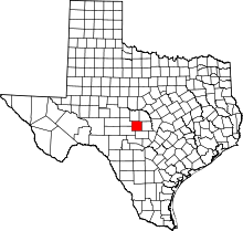 | |
| Unincorporated communities | ||
This article is issued from Wikipedia - version of the 10/12/2015. The text is available under the Creative Commons Attribution/Share Alike but additional terms may apply for the media files.