Abilene State Park
| Abilene State Park | |
|---|---|
|
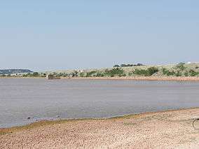
Lake Abilene | |
 | |
| Location | Taylor County, Texas, U.S. |
| Nearest city | Abilene |
| Coordinates | 32°14′7″N 99°52′48″W / 32.23528°N 99.88000°W[1]Coordinates: 32°14′7″N 99°52′48″W / 32.23528°N 99.88000°W[2] |
| Area | 529.4 acres (214.2 ha) |
| Established | 1933 |
| Visitors | 53,750 (in 2007[3]) |
| Governing body | Texas Parks and Wildlife Department |
| http://www.tpwd.state.tx.us/state-parks/abilene | |
Abilene State Park is a 529.4-acre (214.2 ha) park near former Lake Abilene south of Abilene, Texas. It features camping, trailer facilities, picnicking, shelters, a swimming pool, and hiking. A large grove of oak, cedar, elm and pecan trees, now a favorite picnic area, was once a campground for Comanche Indians. The park is located about 15 miles (24 km) southwest of Abilene, on FM 89.
Much of the early development of the park was done by the Civilian Conservation Corps in the 1930s. The stone water tower and the swimming pool complex are the most impressive of the structures built during the period.[4]
See also
| Wikimedia Commons has media related to Abilene State Park. |
References
- ↑ "Abilene State Park". Geographic Names Information System. United States Geological Survey. Retrieved January 6, 2013.
- ↑ "Abilene State Park". Geographic Names Information System. United States Geological Survey. Retrieved January 6, 2013.
- ↑ "Texas State Parks: Natural Economic Assets". Window on State Government. Retrieved January 6, 2013.
- ↑ "Abilene State Park". Texas Parks and Wildlife Department. Retrieved January 6, 2013.
This article is issued from Wikipedia - version of the 11/18/2016. The text is available under the Creative Commons Attribution/Share Alike but additional terms may apply for the media files.