Elmer, New Jersey
| Elmer, New Jersey | |
|---|---|
| Borough | |
| Borough of Elmer | |
|
| |
| Nickname(s): "The Small Town with the Big Welcome"[1] | |
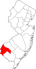
 Elmer highlighted in Salem County. Inset map: Salem County highlighted in the State of New Jersey. | |
 Census Bureau map of Elmer, New Jersey | |
| Coordinates: 39°35′32″N 75°10′28″W / 39.592258°N 75.174569°WCoordinates: 39°35′32″N 75°10′28″W / 39.592258°N 75.174569°W[2][3] | |
| Country |
|
| State |
|
| County | Salem |
| Incorporated | January 28, 1893 |
| Named for | Lucius Elmer |
| Government[4] | |
| • Type | Borough |
| • Body | Borough Council |
| • Mayor | Joseph P. Stemberger (D, term ends December 31, 2019)[5][6] |
| • Clerk | Sarah D. Walker (acting)[7] |
| Area[2] | |
| • Total | 0.877 sq mi (2.273 km2) |
| • Land | 0.865 sq mi (2.241 km2) |
| • Water | 0.012 sq mi (0.032 km2) 1.40% |
| Area rank |
519th of 566 in state 15th of 15 in county[2] |
| Elevation[8] | 115 ft (35 m) |
| Population (2010 Census)[9][10][11] | |
| • Total | 1,395 |
| • Estimate (2015)[12] | 1,343 |
| • Rank |
520th of 566 in state 14th of 15 in county[13] |
| • Density | 1,612.3/sq mi (622.5/km2) |
| • Density rank |
324th of 566 in state 4th of 15 in county[13] |
| Time zone | Eastern (EST) (UTC-5) |
| • Summer (DST) | Eastern (EDT) (UTC-4) |
| ZIP code | 08318[14][15] |
| Area code(s) | 856[16] |
| FIPS code | 3403321240[2][17][18] |
| GNIS feature ID | 885206[2][19] |
| Website |
www |
Elmer is a borough in Salem County in the U.S. state of New Jersey. As of the 2010 United States Census, the borough's population was 1,395,[9][10][11] reflecting an increase of 11 (+0.8%) from the 1,384 counted in the 2000 Census, which had in turn declined by 187 (-11.9%) from the 1,571 counted in the 1990 Census.[20] It is the home of the annual Appel Farm Arts and Music Festival, which celebrated its 23rd year in 2012.[21]
History
Elmer was incorporated as a borough by an act of the New Jersey Legislature on January 28, 1893, from portions of Pittsgrove Township and Upper Pittsgrove Township, based on the results of a referendum held four days earlier.[22] The borough was named for Lucius Elmer a former judge who helped obtain a post office for the community during his service as Congressman.[23][24]
Elmer is a dry town where alcohol cannot be sold.[25][26]
Geography
According to the United States Census Bureau, the borough had a total area of 0.877 square miles (2.273 km2), including 0.865 square miles (2.241 km2) of land and 0.012 square miles (0.032 km2) of water (1.40%).[2][3]
The borough borders Pittsgrove Township and Upper Pittsgrove Township.
Demographics
| Historical population | |||
|---|---|---|---|
| Census | Pop. | %± | |
| 1880 | 345 | — | |
| 1890 | 842 | 144.1% | |
| 1900 | 1,140 | 35.4% | |
| 1910 | 1,167 | 2.4% | |
| 1920 | 1,115 | −4.5% | |
| 1930 | 1,219 | 9.3% | |
| 1940 | 1,344 | 10.3% | |
| 1950 | 1,460 | 8.6% | |
| 1960 | 1,505 | 3.1% | |
| 1970 | 1,592 | 5.8% | |
| 1980 | 1,569 | −1.4% | |
| 1990 | 1,571 | 0.1% | |
| 2000 | 1,384 | −11.9% | |
| 2010 | 1,395 | 0.8% | |
| Est. 2015 | 1,343 | [12][27] | −3.7% |
| Population sources: 1880-1890[28] 1900-2000[29] 1900-1920[30] 1900-1910[31] 1910-1930[32] 1900-2010[33] 2000[34][35] 2010[9][10][11] | |||
Census 2010
At the 2010 United States Census, there were 1,395 people, 536 households, and 390.7 families residing in the borough. The population density was 1,612.3 per square mile (622.5/km2). There were 577 housing units at an average density of 666.9 per square mile (257.5/km2). The racial makeup of the borough was 94.05% (1,312) White, 2.15% (30) Black or African American, 0.57% (8) Native American, 0.79% (11) Asian, 0.00% (0) Pacific Islander, 1.29% (18) from other races, and 1.15% (16) from two or more races. Hispanics or Latinos of any race were 3.15% (44) of the population.[9]
There were 536 households, of which 31.3% had children under the age of 18 living with them, 51.5% were married couples living together, 13.6% had a female householder with no husband present, and 27.1% were non-families. 22.2% of all households were made up of individuals, and 9.3% had someone living alone who was 65 years of age or older. The average household size was 2.60 and the average family size was 3.00.[9]
In the borough, 22.8% of the population were under the age of 18, 8.3% from 18 to 24, 28.5% from 25 to 44, 26.5% from 45 to 64, and 14.0% who were 65 years of age or older. The median age was 39.1 years. For every 100 females there were 95.7 males. For every 100 females age 18 and over, there were 96.5 males.[9]
The Census Bureau's 2006-2010 American Community Survey showed that (in 2010 inflation-adjusted dollars) median household income was $65,417 (with a margin of error of +/- $8,616) and the median family income was $78,661 (+/- $5,812). Males had a median income of $51,685 (+/- $7,458) versus $41,042 (+/- $9,148) for females. The per capita income for the borough was $29,065 (+/- $2,585). About 7.8% of families and 6.5% of the population were below the poverty line, including 8.7% of those under age 18 and 6.8% of those age 65 or over.[36]
Census 2000
As of the 2000 United States Census[17] there were 1,384 people, 524 households, and 385 families residing in the borough. The population density was 1,599.5 people per square mile (614.2/km2). There were 557 housing units at an average density of 643.7 per square mile (247.2/km2). The racial makeup of the borough was 97.25% White, 0.65% African American, 0.51% Asian, 0.72% from other races, and 0.87% from two or more races. Hispanic or Latino of any race were 1.52% of the population.[34][35]
There were 524 households out of which 35.7% had children under the age of 18 living with them, 58.0% were married couples living together, 11.6% had a female householder with no husband present, and 26.5% were non-families. 22.3% of all households were made up of individuals and 10.1% had someone living alone who was 65 years of age or older. The average household size was 2.61 and the average family size was 3.06.[34][35]
In the borough the population was spread out with 24.4% under the age of 18, 8.6% from 18 to 24, 29.8% from 25 to 44, 21.7% from 45 to 64, and 15.5% who were 65 years of age or older. The median age was 37 years. For every 100 females there were 94.1 males. For every 100 females age 18 and over, there were 87.5 males.[34][35]
The median income for a household in the borough was $46,172, and the median income for a family was $58,438. Males had a median income of $39,896 versus $27,583 for females. The per capita income for the borough was $21,356. About 4.6% of families and 5.3% of the population were below the poverty line, including 6.2% of those under age 18 and 3.3% of those age 65 or over.[34][35]
Government


Local government
Elmer is governed under the Borough form of New Jersey municipal government. The governing body consists of a Mayor and a Borough Council comprising six council members, with all positions elected at-large on a partisan basis as part of the November general election. A Mayor is elected directly by the voters to a four-year term of office. The Borough Council consists of six members elected to serve three-year terms on a staggered basis, with two seats coming up for election each year in a three-year cycle.[4] The Borough form of government used by Elmer, the most common system used in the state, is a "weak mayor / strong council" government in which council members act as the legislative body with the mayor presiding at meetings and voting only in the event of a tie. The mayor can veto ordinances subject to an override by a two-thirds majority vote of the council. The mayor makes committee and liaison assignments for council members, and most appointments are made by the mayor with the advice and consent of the council.[37][38]
As of 2016, the Mayor of Elmer Borough is Democrat Joseph P. Stemberger, whose term of office expires on December 31, 2019. Members of the Elmer Borough Council are Council President Lewis M. Schneider (R, 2018), Lynda Davis (R, 2016), Cynthia L. Nolan (R, 2017), R. Matthew Richards (R, 2017), Steven A. Schalick (R, 2016) and James W. Zee, III (R, 2018).[5][39][40][41][42][43][44]
Federal, state and county representation
Elmer is located in the 2nd Congressional District[45] and is part of New Jersey's 3rd state legislative district.[10][46][47]
New Jersey's Second Congressional District is represented by Frank LoBiondo (R, Ventnor City).[48] New Jersey is represented in the United States Senate by Cory Booker (D, Newark, term ends 2021)[49] and Bob Menendez (D, Paramus, 2019).[50][51]
For the 2016–2017 session (Senate, General Assembly), the 3rd Legislative District of the New Jersey Legislature is represented in the State Senate by Stephen M. Sweeney (D, West Deptford Township) and in the General Assembly by John J. Burzichelli (D, Paulsboro) and Adam Taliaferro (D, Woolwich Township).[52] The Governor of New Jersey is Chris Christie (R, Mendham Township).[53] The Lieutenant Governor of New Jersey is Kim Guadagno (R, Monmouth Beach).[54]
Salem County is governed by a seven-member Board of Chosen Freeholders who are elected at-large to serve three-year terms of office on a staggered basis, with either two or three seats coming up for election each year. At an annual reorganization meeting held in the beginning of January, the board selects a Director and a Deputy Director from among its members. As of 2014, Salem County's Freeholders (with party, residence, term-end year and committee chairmanship listed in parentheses) are Director Julie A. Acton (R, Pennsville Township, 2016; Administration), Deputy Director Dale A. Cross (R, Pennsville Township, 2014; Public Safety), Bruce L. Bobbitt (D, Pilesgrove Township, 2014; Public Services), Ben Laury (R, Elmer, 2015; Public Works) Beth E. Timberman (D, Woodstown, 2015; Social Services), Robert J. Vanderslice (R, Pennsville Township, 2014; Health and Human Services) Lee R. Ware (D, Elsinboro Township, 2016; Transportation, Agriculture and Cultural Affairs).[55][56] Constitutional officers elected on a countywide basis are County Clerk Gilda T. Gill (2014),[57] Sheriff Charles M. Miller (2015)[58] and Surrogate Nicki A. Burke (2015).[59][60]
Politics
As of March 23, 2011, there were a total of 852 registered voters in Elmer, of whom 201 (23.6% vs. 30.6% countywide) were registered as Democrats, 253 (29.7% vs. 21.0%) were registered as Republicans and 397 (46.6% vs. 48.4%) were registered as Unaffiliated. There was one voter registered to another party.[61] Among the borough's 2010 Census population, 61.1% (vs. 64.6% in Salem County) were registered to vote, including 79.1% of those ages 18 and over (vs. 84.4% countywide).[61][62]
In the 2012 presidential election, Republican Mitt Romney received 60.4% of the vote (356 cast), ahead of Democrat Barack Obama with 38.0% (224 votes), and other candidates with 1.5% (9 votes), among the 593 ballots cast by the borough's 875 registered voters (4 ballots were spoiled), for a turnout of 67.8%.[63][64] In the 2008 presidential election, Republican John McCain received 375 votes (56.4% vs. 46.6% countywide), ahead of Democrat Barack Obama with 261 votes (39.2% vs. 50.4%) and other candidates with 15 votes (2.3% vs. 1.6%), among the 665 ballots cast by the borough's 892 registered voters, for a turnout of 74.6% (vs. 71.8% in Salem County).[65] In the 2004 presidential election, Republican George W. Bush received 414 votes (62.4% vs. 52.5% countywide), ahead of Democrat John Kerry with 242 votes (36.5% vs. 45.9%) and other candidates with 5 votes (0.8% vs. 1.0%), among the 663 ballots cast by the borough's 904 registered voters, for a turnout of 73.3% (vs. 71.0% in the whole county).[66]
In the 2013 gubernatorial election, Republican Chris Christie received 75.5% of the vote (329 cast), ahead of Democrat Barbara Buono with 21.8% (95 votes), and other candidates with 2.8% (12 votes), among the 440 ballots cast by the borough's 897 registered voters (4 ballots were spoiled), for a turnout of 49.1%.[67][68] In the 2009 gubernatorial election, Republican Chris Christie received 234 votes (53.8% vs. 46.1% countywide), ahead of Democrat Jon Corzine with 155 votes (35.6% vs. 39.9%), Independent Chris Daggett with 38 votes (8.7% vs. 9.7%) and other candidates with 5 votes (1.1% vs. 2.0%), among the 435 ballots cast by the borough's 876 registered voters, yielding a 49.7% turnout (vs. 47.3% in the county).[69]
Education
As of May 2010, Elmer students attend the schools of the Pittsgrove Township School District as part of a full sending/receiving relationship in which the former Elmer School is integrated into the district and Elmer and Pittsgrove Township students attend school together throughout their education.[70] [71][72]
Schools in the district (with 2012-13 enrollment data from the National Center for Education Statistics[73]) are Norma Elementary School[74] for Preschool-K (167 students), Elmer Elementary School[75] for grades 1-2 (212), Olivet Elementary School[76] for grades 3-5 (373), Pittsgrove Township Middle School[77] for grades 6-8 (467) and A.P. Schalick High School[78] for grades 9-12 (577).[79][80]
Transportation
As of May 2010, the borough had a total of 9.54 miles (15.35 km) of roadways, of which 5.18 miles (8.34 km) were maintained by the municipality, 3.67 miles (5.91 km) by Salem County and 0.69 miles (1.11 km) by the New Jersey Department of Transportation.[81]
Notable people
People who were born in, residents of, or otherwise closely associated with Elmer include:
- King Brady (1881-1947), MLB pitcher.[82]
- Todd Barranger (born 1968), professional golfer.[83]
- David Mixner (born 1946), civil rights activist and author.[84]
References
- ↑ Kuperinsky, Amy. "'The Jewel of the Meadowlands'?: N.J.'s best, worst and weirdest town slogans", NJ Advance Media for NJ.com, January 22, 2015. Accessed July 12, 2016. "Elmer, a borough 40 minutes outside Philadelphia in Salem County, calls itself 'The Small Town with the Big Welcome.' The 'small' refers to the one-square-mile size and population of 1,351."
- 1 2 3 4 5 6 2010 Census Gazetteer Files: New Jersey County Subdivisions, United States Census Bureau. Accessed May 21, 2015.
- 1 2 US Gazetteer files: 2010, 2000, and 1990, United States Census Bureau. Accessed September 4, 2014.
- 1 2 2012 New Jersey Legislative District Data Book, Rutgers University Edward J. Bloustein School of Planning and Public Policy, March 2013, p. 19.
- 1 2 Elected Officials, Borough of Elmer. Accessed July 29, 2016.
- ↑ 2016 New Jersey Mayors Directory, New Jersey Department of Community Affairs. Accessed June 14, 2016.
- ↑ Borough Officers, Borough of Elmer. Accessed July 29, 2016.
- ↑ U.S. Geological Survey Geographic Names Information System: Borough of Elmer, Geographic Names Information System. Accessed March 5, 2013.
- 1 2 3 4 5 6 DP-1 - Profile of General Population and Housing Characteristics: 2010 for Elmer borough, Salem County, New Jersey, United States Census Bureau. Accessed January 17, 2013.
- 1 2 3 4 Municipalities Grouped by 2011-2020 Legislative Districts, New Jersey Department of State, p. 2. Accessed January 6, 2013.
- 1 2 3 Profile of General Demographic Characteristics: 2010 for Elmer borough, New Jersey Department of Labor and Workforce Development. Accessed January 17, 2013.
- 1 2 PEPANNRES - Annual Estimates of the Resident Population: April 1, 2010 to July 1, 2015 - 2015 Population Estimates for New Jersey municipalities, United States Census Bureau. Accessed May 22, 2016.
- 1 2 GCT-PH1 Population, Housing Units, Area, and Density: 2010 - State -- County Subdivision from the 2010 Census Summary File 1 for New Jersey, United States Census Bureau. Accessed January 17, 2013.
- ↑ Look Up a ZIP Code for Elmer, NJ, United States Postal Service. Accessed January 17, 2013.
- ↑ Zip Codes, State of New Jersey. Accessed August 28, 2013.
- ↑ Area Code Lookup - NPA NXX for Elmer, NJ, Area-Codes.com. Accessed October 9, 2013.
- 1 2 American FactFinder, United States Census Bureau. Accessed September 4, 2014.
- ↑ A Cure for the Common Codes: New Jersey, Missouri Census Data Center. Accessed October 28, 2012.
- ↑ US Board on Geographic Names, United States Geological Survey. Accessed September 4, 2014.
- ↑ Table 7. Population for the Counties and Municipalities in New Jersey: 1990, 2000 and 2010, New Jersey Department of Labor and Workforce Development, February 2011. Accessed January 17, 2013.
- ↑ LaGorce, Tammy. "A Trio of Events With Music in Many Moods", The New York Times, May 25, 2012. Accessed January 17, 2013. "The Appel Farm Arts and Music Festival, to be held June 2 in Elmer from 11:30 a.m. to 8:30 p.m., draws more famous names, most of them closely aligned with the adult-alternative genre.... Now in its 23rd year, the festival delivers fans by the thousands to the 60-acre grassy site in Salem County; its artistic director, Sean Timmons, is expecting close to 5,000 this year."
- ↑ Snyder, John P. The Story of New Jersey's Civil Boundaries: 1606-1968, Bureau of Geology and Topography; Trenton, New Jersey; 1969. p. 215. Accessed October 25, 2012.
- ↑ History, Elmer Borough. Accessed July 29, 2016. "The town was named after Judge Lucius Quintus Cincinnatus Elmer, a jurist respected state-wide, who had presided over Salem County's then-famous Treadway murder case and also produced the first compendium of New Jersey state statutes. As a Congressman, Elmer was largely responsible for securing a post office for the town."
- ↑ Hutchinson, Viola L. The Origin of New Jersey Place Names, New Jersey Public Library Commission, May 1945. Accessed August 30, 2015.
- ↑ New Jersey Division of Alcoholic Beverage Control. New Jersey ABC list of dry towns (May 1, 2013)
- ↑ Giordano, Rita. "More towns catching liquor-license buzz; Moorestown considers ending its dry spell", The Philadelphia Inquirer, June 24, 2007. Accessed February 16, 2014.
- ↑ Census Estimates for New Jersey April 1, 2010 to July 1, 2015, United States Census Bureau. Accessed May 22, 2016.
- ↑ Report on Population of the United States at the Eleventh Census: 1890. Part I, p. 239. United States Census Bureau, 1895. Accessed October 20, 2016.
- ↑ Barnett, Bob. Population Data for Salem County Municipalities, 1810 - 2000, WestJersey.org, January 6, 2011. Accessed January 17, 2013.
- ↑ Compendium of censuses 1726-1905: together with the tabulated returns of 1905, New Jersey Department of State, 1906. Accessed October 9, 2013.
- ↑ Thirteenth Census of the United States, 1910: Population by Counties and Minor Civil Divisions, 1910, 1900, 1890, United States Census Bureau, p. 338. Accessed January 17, 2013.
- ↑ Fifteenth Census of the United States : 1930 - Population Volume I, United States Census Bureau, p. 718. Accessed January 17, 2013.
- ↑ New Jersey Resident Population by Municipality: 1930 - 1990, Workforce New Jersey Public Information Network. Accessed June 28, 2015.
- 1 2 3 4 5 Census 2000 Profiles of Demographic / Social / Economic / Housing Characteristics for Elmer borough, New Jersey, United States Census Bureau. Accessed January 17, 2013.
- 1 2 3 4 5 DP-1: Profile of General Demographic Characteristics: 2000 - Census 2000 Summary File 1 (SF 1) 100-Percent Data for Elmer borough, Salem County, New Jersey, United States Census Bureau. Accessed January 17, 2013.
- ↑ DP03: Selected Economic Characteristics from the 2006-2010 American Community Survey 5-Year Estimates for Elmer borough, Salem County, New Jersey, United States Census Bureau. Accessed January 17, 2013.
- ↑ Cerra, Michael F. "Forms of Government: Everything You've Always Wanted to Know, But Were Afraid to Ask", New Jersey State League of Municipalities. Accessed November 30, 2014.
- ↑ "Forms of Municipal Government in New Jersey", p. 6. Rutgers University Center for Government Studies. Accessed June 3, 2015.
- ↑ 2016 Municipal User Friendly Budget, Borough of Elmer. Accessed July 29, 2016.
- ↑ The Official Salem County Directory, Salem County, New Jersey, February 4, 2016. Accessed July 29, 2016.
- ↑ Municipalities in Salem County, Salem County, New Jersey Clerk. Accessed July 29, 2016.
- ↑ November 3, 2015Summary ReportSalem County Official results, Salem County, New Jersey Clerk, updated January 13, 2016. Accessed July 29, 2016.
- ↑ November 4, 2014 Summary Report Salem County Official Results, Salem County, New Jersey Clerk, updated November 24, 2014. Accessed July 29, 2016.
- ↑ November 5, 2013 Summary Report Salem County Unofficial Results, Salem County, New Jersey, updated November 5, 2013. Accessed July 29, 2016.
- ↑ Plan Components Report, New Jersey Redistricting Commission, December 23, 2011. Accessed January 6, 2013.
- ↑ 2016 New Jersey Citizen's Guide to Government, p. 56, New Jersey League of Women Voters. Accessed July 20, 2016.
- ↑ Districts by Number for 2011-2020, New Jersey Legislature. Accessed January 6, 2013.
- ↑ Directory of Representatives: New Jersey, United States House of Representatives. Accessed January 5, 2012.
- ↑ About Cory Booker, United States Senate. Accessed January 26, 2015. "He now owns a home and lives in Newark's Central Ward community."
- ↑ Biography of Bob Menendez, United States Senate, January 26, 2015. "He currently lives in Paramus and has two children, Alicia and Robert."
- ↑ Senators of the 114th Congress from New Jersey. United States Senate. Accessed January 26, 2015. "Booker, Cory A. - (D - NJ) Class II; Menendez, Robert - (D - NJ) Class I"
- ↑ Legislative Roster 2016-2017 Session, New Jersey Legislature. Accessed January 17, 2016.
- ↑ "About the Governor". State of New Jersey. Retrieved 2010-01-21.
- ↑ "About the Lieutenant Governor". State of New Jersey. Retrieved 2010-01-21.
- ↑ Board of Chosen Freeholders, Salem County, New Jersey. Accessed July 27, 2014.
- ↑ 2014 County Data Sheet, Salem County, New Jersey. Accessed July 27, 2014.
- ↑ County Clerk, Salem County Clerk's Office . Accessed July 27, 2014.
- ↑ Sheriff's Office, Salem County, New Jersey. Accessed July 27, 2014.
- ↑ Surrogate's Court, Salem County, New Jersey. Accessed July 27, 2014.
- ↑ The Official 2013 Salem County Directory, Salem County, New Jersey. Accessed July 27, 2014.
- 1 2 Voter Registration Summary - Salem, New Jersey Department of State Division of Elections, March 23, 2011. Accessed January 17, 2013.
- ↑ GCT-P7: Selected Age Groups: 2010 - State -- County Subdivision; 2010 Census Summary File 1 for New Jersey, United States Census Bureau. Accessed January 17, 2013.
- ↑ "Presidential General Election Results - November 6, 2012 - Salem County" (PDF). New Jersey Department of Elections. March 15, 2013. Retrieved December 24, 2014.
- ↑ "Number of Registered Voters and Ballots Cast - November 6, 2012 - General Election Results - Salem County" (PDF). New Jersey Department of Elections. March 15, 2013. Retrieved December 24, 2014.
- ↑ 2008 Presidential General Election Results: Salem County, New Jersey Department of State Division of Elections, December 23, 2008. Accessed January 17, 2013.
- ↑ 2004 Presidential Election: Salem County, New Jersey Department of State Division of Elections, December 13, 2004. Accessed January 17, 2013.
- ↑ "Governor - Salem County" (PDF). New Jersey Department of Elections. January 29, 2014. Retrieved December 24, 2014.
- ↑ "Number of Registered Voters and Ballots Cast - November 5, 2013 - General Election Results - Salem County" (PDF). New Jersey Department of Elections. January 29, 2014. Retrieved December 24, 2014.
- ↑ 2009 Governor: Salem County, New Jersey Department of State Division of Elections, December 31, 2009. Accessed January 17, 2013.
- ↑ Dailey, Jennifer. "Elmer and Pittsgrove school districts to merge through send and receive agreement", Today's Sunbeam, June 17, 2009. Accessed October 9, 2013. "The Elmer Board of Education voted unanimously during its school board meeting here Tuesday night to merge with Pittsgrove through a full send and receive agreement. The agreement could have Elmer and Pittsgrove students attending school together."
- ↑ Dunn, Phil. "Pittsgrove Township Board of Education weighing how many choice students it will accept into district", Today's Sunbeam, December 19, 2011. Accessed October 9, 2013. "Brodzik said the 2011 number includes the influx of students they gained from Elmer since the school became part of the Pittsgrove district."
- ↑ Elmer Elementary School 2014 Report Card Narrative, New Jersey Department of Education. Accessed July 19, 2016. "The Elmer School has been part of the Pittsgrove Township School District for 4 years. Previously the Borough of Elmer's Kindergarten through fourth grade children attended school at the Elmer School while the rest of their students participated in a send/receive agreement with Pittsgrove Township Schools for grades five through twelve. A full send/receive agreement with the Elmer Borough Board of Education was reached for the 2010-2011 school year. All students from both Pittsgrove and Elmer attend school together from preschool through twelfth grade. Elmer Elementary School now houses 200 Pittsgrove and Elmer students in grades one and two"
- ↑ School Data for the Pittsgrove Township School District, National Center for Education Statistics. Accessed February 17, 2015.
- ↑ Norma Elementary School, Pittsgrove Township School District. Accessed October 9, 2013.
- ↑ Elmer Elementary School, Pittsgrove Township School District. Accessed October 9, 2013.
- ↑ Olivet Elementary School, Pittsgrove Township School District. Accessed October 9, 2013.
- ↑ Pittsgrove Township Middle School, Pittsgrove Township School District. Accessed October 9, 2013.
- ↑ A.P. Schalick High School, Pittsgrove Township School District. Accessed October 9, 2013.
- ↑ Schools, Pittsgrove Township School District. Accessed October 9, 2013.
- ↑ New Jersey School Directory for the Pittsgrove Township School District, New Jersey Department of Education. Accessed October 9, 2013.
- ↑ Salem County Mileage by Municipality and Jurisdiction, New Jersey Department of Transportation, May 2010. Accessed July 18, 2014.
- ↑ King Brady, MLB.com. Accessed April 28, 2015.
- ↑ Todd Barranger, Fox Sports. Accessed April 28, 2015.
- ↑ Mixner, David. "Turkey Hollow Almanac: My Birthday", DavidMixner.com, August 17, 2008. Accessed April 28, 2015. "Growing up in Elmer, New Jersey, birthdays were never a big deal."
External links
- Elmer Borough website
- Elmer School website
- Elmer School's 2014–15 School Report Card from the New Jersey Department of Education
- School Data for the Elmer School, National Center for Education Statistics