Slapes Corner, New Jersey
| Slapes Corner, New Jersey | |
|---|---|
| Unincorporated community | |
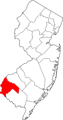
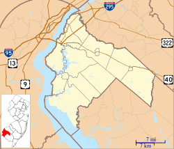 Slapes Corner, New Jersey  Slapes Corner, New Jersey  Slapes Corner, New Jersey Slapes Corner's location in Salem County (Inset: Salem County in New Jersey) | |
| Coordinates: 39°38′23″N 75°26′9″W / 39.63972°N 75.43583°WCoordinates: 39°38′23″N 75°26′9″W / 39.63972°N 75.43583°W | |
| Country |
|
| State |
|
| County | Salem |
| Township | Mannington |
| Elevation[1] | 5 m (16 ft) |
| Time zone | Eastern (EST) (UTC-5) |
| • Summer (DST) | EDT (UTC-4) |
| GNIS feature ID | 880640[1] |
Slapes Corner is an unincorporated community located within Mannington Township, in Salem County, New Jersey, United States.[1][2][3]
The community is centered at County Route 540, Marshalltown Road and Pointers Auburn Road, located 1.0 mile (1.6 km) east of Marshalltown and 3.4 miles (5.5 km) east-southeast of Glenside.[4]
References
- 1 2 3 Feature Detail Report for: Slapes Corner, Geographic Names Information System. Accessed January 1, 2015.
- ↑ Locality Search, State of New Jersey. Accessed January 1, 2015.
- ↑ Areas covering the point (-75.435833,39.639722), MapIt. Accessed January 1, 2015.
- ↑ N 39.639722 W 75.435833, ACME Mapper. Accessed January 1, 2015.
This article is issued from Wikipedia - version of the 6/10/2016. The text is available under the Creative Commons Attribution/Share Alike but additional terms may apply for the media files.