Pedricktown, New Jersey
| Pedricktown, New Jersey | |
|---|---|
| Census-designated place | |
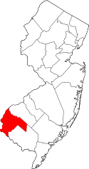
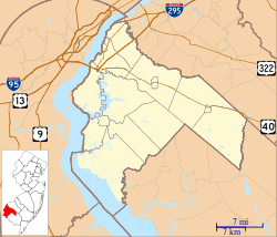 Pedricktown, New Jersey  Pedricktown, New Jersey  Pedricktown, New Jersey Location of Pedricktown in Salem County (Inset: Salem County in New Jersey) | |
| Coordinates: 39°45′59″N 75°24′27″W / 39.76643°N 75.407591°WCoordinates: 39°45′59″N 75°24′27″W / 39.76643°N 75.407591°W[1][2] | |
| Country |
|
| State |
|
| County | Salem |
| Township | Oldmans |
| Area[1] | |
| • Total | 0.905 sq mi (2.345 km2) |
| • Land | 0.903 sq mi (2.340 km2) |
| • Water | 0.002 sq mi (0.005 km2) 0.21% |
| Elevation[3] | 10 ft (3 m) |
| Population (2010 Census)[4] | |
| • Total | 524 |
| • Density | 580.0/sq mi (223.9/km2) |
| Time zone | Eastern (EST) (UTC-5) |
| • Summer (DST) | Eastern (EDT) (UTC-4) |
| ZIP code | 08067[5] |
| Area code(s) | 856 |
| FIPS code | 3457360[6] |
| GNIS feature ID | 02584016[7] |
Pedricktown is an unincorporated community and census-designated place (CDP) located within Oldmans Township, in Salem County, New Jersey, United States.[8][9][10][11] As of the 2010 United States Census, the CDP's population was 524.[4] The area is served as United States Postal Service ZIP code 08067.
Geography
According to the United States Census Bureau, Pedricktown had a total area of 0.905 square miles (2.345 km2), including 0.903 square miles (2.340 km2) of land and 0.002 square miles (0.005 km2) of water (0.21%).[1][2]
Demographics
Census 2010
The 2010 United States Census counted 524 people, 197 households, and 147 families residing in the CDP. The population density was 580.0 per square mile (223.9/km2). The CDP contained 220 housing units at an average density of 243.5 per square mile (94.0/km2). The racial makeup of the CDP was 91.79% (481) White, 2.67% (14) Black or African American, 0.00% (0) Native American, 0.19% (1) Asian, 0.00% (0) Pacific Islander, 4.58% (24) from other races, and 0.76% (4) from two or more races. Hispanics or Latinos of any race were 9.92% (52) of the population.[4]
Out of a total of 197 households, 36.0% had children under the age of 18 living with them, 53.8% were married couples living together, 13.2% had a female householder with no husband present, and 25.4% were non-families. 20.3% of all households were made up of individuals, and 5.1% had someone living alone who was 65 years of age or older. The average household size was 2.66 and the average family size was 3.04.[4]
In the CDP, 26.9% of the population were under the age of 18, 6.7% from 18 to 24, 28.4% from 25 to 44, 27.5% from 45 to 64, and 10.5% who were 65 years of age or older. The median age was 36.0 years. For every 100 females the census counted 94.8 males, but for 100 females at least 18 years old, it was 100.5 males.[4]
Economy
Goya Foods has its South Jersey division in Pedricktown.[12]
Wineries
- Salem Oak Vineyards
Transportation
Pedricktown is accessible at Exit 7 of Interstate 295 via County Route 643.
The Spitfire Aerodrome (FAA LID: 7N7) is a small municipal airport located in Pedricktown.[13]
References
- 1 2 3 Gazetteer of New Jersey Places, United States Census Bureau. Accessed July 21, 2016.
- 1 2 US Gazetteer files: 2010, 2000, and 1990, United States Census Bureau. Accessed September 4, 2014.
- ↑ U.S. Geological Survey Geographic Names Information System: Pedricktown Census Designated Place, Geographic Names Information System. Accessed February 9, 2013.
- 1 2 3 4 5 DP-1 - Profile of General Population and Housing Characteristics: 2010 Demographic Profile Data for Pedricktown CDP, New Jersey, United States Census Bureau. Accessed February 9, 2013.
- ↑ Look Up a ZIP Code for Pedricktown, NJ, United States Postal Service. Accessed September 27, 2012.
- ↑ American FactFinder, United States Census Bureau. Accessed September 4, 2014.
- ↑ US Board on Geographic Names, United States Geological Survey. Accessed September 4, 2014.
- ↑ GCT-PH1 - Population, Housing Units, Area, and Density: 2010 - County -- County Subdivision and Place from the 2010 Census Summary File 1 for Salem County, New Jersey, United States Census Bureau. Accessed February 9, 2013.
- ↑ 2006-2010 American Community Survey Geography for New Jersey, United States Census Bureau. Accessed February 9, 2013.
- ↑ New Jersey: 2010 - Population and Housing Unit Counts - 2010 Census of Population and Housing (CPH-2-32), United States Census Bureau, August 2012. Accessed February 9, 2013.
- ↑ Locality Search, State of New Jersey. Accessed April 19, 2015.
- ↑ Contact Us. Goya Foods. Accessed March 26, 2016. "Goya Foods of South Jersey 1 Industrial Way Pedricktown, NJ 08067"
- ↑ Spitfire Aerodrome, New Jersey Department of Transportation. Accessed July 22, 2016.