Dawson Creek
| Dawson Creek | |||
|---|---|---|---|
| City | |||
| The Corporation of the City of Dawson Creek | |||
|
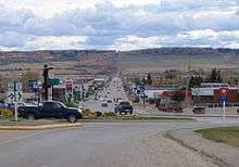
Looking south into downtown Dawson Creek, with the Mile "0" post. | |||
| |||
| Nickname(s): Capital of the Peace, Mile 0 City | |||
 Dawson Creek Location of Dawson Creek in British Columbia | |||
| Coordinates (City Hall): 55°45′38″N 120°14′08″W / 55.76056°N 120.23556°WCoordinates: 55°45′38″N 120°14′08″W / 55.76056°N 120.23556°W | |||
| Country | Canada | ||
| Province | British Columbia | ||
| Region | Peace River | ||
| Incorporated |
May 26, 1936 (village) January 6, 1958 (city) | ||
| Government[1] | |||
| • MP | Bob Zimmer | ||
| • MLA | Mike Bernier | ||
| Area | |||
| • City | 24.37 km2 (9.41 sq mi) | ||
| Elevation | 665 m (2,182 ft) | ||
| Population (2011) | |||
| • City | 11,583 | ||
| • Density | 475.4/km2 (1,231/sq mi) | ||
| • Urban | 11,583 | ||
| • Urban density | 475.4/km2 (1,231/sq mi) | ||
| • Metro | 11,583 | ||
| • Metro density | 475.4/km2 (1,231/sq mi) | ||
| Time zone | Mountain Time Zone[2] (UTC−7) | ||
| • Summer (DST) | not observed (UTC−7) | ||
| Postal code FSA | V1G | ||
| Area code(s) | 250 / 778 / 236 | ||
| Highways |
| ||
| Website | City of Dawson Creek | ||


Dawson Creek is a city in northeastern British Columbia, Canada. The municipality of 24.37 square kilometres (9.41 sq mi) had a population of 11,583 in 2011.[3] Dawson Creek derives its name from the creek of the same name that runs through the community. The creek was named after George Mercer Dawson by a member of his land survey team when they passed through the area in August 1879. Once a small farming community, Dawson Creek became a regional centre after the western terminus of the Northern Alberta Railways was extended there in 1932. The community grew rapidly in 1942 as the US Army used the rail terminus as a transshipment point during construction of the Alaska Highway. In the 1950s, the city was connected to the interior of British Columbia via a highway and railway through the Rocky Mountains. Since the 1960s, growth has slowed.
Dawson Creek is located in the dry and windy prairie land of the Peace River Country. As the seat of the Peace River Regional District and a service centre for the rural areas south of the Peace River, the city has been called the "Capital of the Peace". It is also known as the "Mile 0 City", referring to its location at the southern end of the Alaska Highway. It also has a heritage interpretation village, an art gallery, and a museum. Annual events include a fall fair and rodeo.
History
Dawson Creek is named after the watercourse of the same name, itself named after George Mercer Dawson who led a surveying team through the area in August 1879; a member of the team labelled the creek with Dawson's name.[4] The community that formed by the creek was one of many farming communities established by European-Canadian settlers moving west through the Peace River Country. When the Canadian government began issuing homestead grants to settlers in 1912, the pace of migration increased. With the opening of a few stores and hotels in 1919 and the incorporation of the Dawson Creek Co-operative Union on 28 May 1921, Dawson Creek became a dominant business centre in the area.[5] After much speculation by land owners and investors, the Northern Alberta Railways built its western terminus 3 km (2 mi) from Dawson Creek.[6] The golden spike was driven on 29 December 1930, and the first passenger train arrived on 15 January 1931. The arrival of the railway and the construction of grain elevators attracted more settlers and business to the settlement. The need to provide services for the rapidly growing community led Dawson Creek to incorporate as a village in May 1936. A small wave of refugees from the Sudetenland settled in the area in 1939 as World War II was beginning.[7] The community exceeded 500 people in 1941.[8]
Upon entering the war, the United States decided to build a transportation corridor to connect the US mainland to Alaska. In 1942, thousands of US Army personnel, engineers, and contractors poured into the city – the terminal of rail transport – to construct the Alaska Highway. The highway was completed in less than a year; even after the workers involved in its construction departed, population and economic growth continued. In February 1943, a major fire and explosion in a livery barn, packed with road-building supplies including dynamite, caused serious damage to the center of town; five people were killed and 150 injured.[9][10]
By 1951, Dawson Creek had more than 3,500 residents.[8] In 1952, the John Hart Highway linked the town to the rest of the British Columbia Interior and Lower Mainland through the Rocky Mountains;[11] a new southbound route, known locally as Tupper Highway, made the town a crossroads with neighbouring Alberta. The next year, western Canada's largest propane gas plant was built[12] and federal government offices were established in town. In 1958, the extension of the Pacific Great Eastern Railway to the Peace from Prince George was completed,[11] and the village was re-incorporated as a city. Between 1951 and 1961, the population of Dawson Creek more than tripled.
Growth slowed in the 1960s, with the population reaching its all-time high in 1966. In the 1970s, the provincial government moved its regional offices from Pouce Coupe to the city, Northern Lights College opened a Dawson Creek campus, and the Dawson Creek Mall was constructed. Several modern grain elevators were built, and the town's five wooden grain elevators, nicknamed "Elevator Row", were taken out of service. Only one of the historic elevators remains, converted to an art gallery. Since the 1970s, with the nearby town of Fort St. John attracting much of the area's industrial development and Grande Prairie becoming a commercial hub, the town's population and economy have not significantly increased.
Since 1992, the city has undergone several boundary expansions. One expansion incorporated undeveloped land in the southeast for an industrial park and a Louisiana-Pacific Canada veneer factory.[13] The city extended sewer and water lines to the location; however, the area was not developed and with the factory only half-built, L-P Canada abandoned its plans. A business making manufactured homes bought the factory and completed its development in 2005.[14] Another expansion incorporated the existing oriented strand board factory in the northwest corner of the city, while further incorporations have included undeveloped land to the south and north.
Demographics
The 1941 census, the first to include Dawson Creek as a defined subdivision, counted 518 residents.[8] Its growth spurred by the construction of the Alaska Highway, the town recorded a sevenfold increase to 3,589 residents in the 1951 census. Within five years, the population doubled to 7,531.[8] New transport links with southern British Columbia and Alberta spurred continued growth into the next decade. The population peaked in 1966 at 12,392, then declined throughout the 1970s, rising again briefly during the construction of the nearby town of Tumbler Ridge in the early 1980s. Dawson Creek's population has remained relatively stable since then. Between 2005 and 2009, the population rose from 10,869 to 11,514, per provincial estimates.[3]
| Canada 2011 Census[3] | ||
| Dawson Creek | British Columbia | |
| Median age | 36.2 years | 41.9 years |
| Under 15 years old | 19% | 15% |
| Over 65 years old | 13% | 16% |
| Visible minority | 5% | 27% |
According to the 2006 Canadian census, there were 10,994 people living in 4,650 households within the city[15] (the official provincial estimate was 11,093 people[16]). Of the federally surveyed households, 33% were one-person households, slightly above the 28% average provincewide; households consisting of couples with children, at 26%, were very close to the provincial average; and households of couples without children, at 24%, were below the provincial average of 30%. Among its 3,000 census families, Dawson Creek had a smaller proportion of married couples than the province, 62% compared to 73%, but the same average number of persons per family, 2.9. With 92% of Dawson Creek residents being Canadian-born, and 93% speaking only English, the city has few visible minorities. Only 17% of residents aged 35–64 had a university certificate or diploma, compared to the provincewide rate of 29%. Among those aged 25–64, 20% did not have a high school certificate or equivalent, much higher than the 12% provincewide rate.[15]
In 2005, the 22-officer Dawson Creek Royal Canadian Mounted Police municipal detachment reported 2,561 Criminal Code offences. This translated into a crime rate of 225 Criminal Code offences per 1,000 people, down from the previous year's rate of 231, but still much higher than the provincial average of 125. In 2004, per 1,000 people, the city had higher crime rates compared to the provincial averages on all Criminal Code offences except theft from motor vehicles (19.8 city, 20.2 province), heroin-related offences (0 city, 0.13 province), and murder (0 city, 0.03 province). The city had slightly higher but comparable levels of offensive weapons charges, cannabis-related offences, robbery, and motor vehicle thefts. Per 1,000 people, the city had much higher levels of shoplifting (13.8 city, 4.2 province), cocaine-related offences (7.8 city, 1.4 province), commercial break-and-enters (11.2 city, 4.2 province), residential break-and-enters (13.9 city, 6.0 province), and non-sexual assaults (26.2 city, 9.9 province).[17]


| Historical population | ||
|---|---|---|
| Year | Pop. | ±% |
| 1941 | 518 | — |
| 1951 | 3,589 | +592.9% |
| 1961 | 10,946 | +205.0% |
| 1981 | 11,373 | +3.9% |
| 1991 | 10,981 | −3.4% |
| 1996 | 11,125 | +1.3% |
| 2001 | 10,754 | −3.3% |
| 2006 | 10,994 | +2.2% |
| 2011 | 11,583 | +5.4% |
| [20][21][22] | ||
| Canada 2011 Census | Population | % of Total Population | |
|---|---|---|---|
| Visible minority group Source:[23] |
South Asian | 320 | 2.8% |
| Chinese | 55 | 0.5% | |
| Black | 30 | 0.3% | |
| Filipino | 85 | 0.8% | |
| Latin American | 35 | 0.3% | |
| Arab | 0 | 0% | |
| Southeast Asian | 50 | 0.4% | |
| West Asian | 0 | 0% | |
| Korean | 25 | 0.2% | |
| Japanese | 0 | 0% | |
| Other visible minority | 0 | 0% | |
| Mixed visible minority | 0 | 0% | |
| Total visible minority population | 605 | 5.4% | |
| Aboriginal group Source:[24] | First Nations | 535 | 4.8% |
| Métis | 1,080 | 9.6% | |
| Inuit | 0 | 0% | |
| Total Aboriginal population | 1,645 | 14.6% | |
| White | 8,995 | 80% | |
| Total population | 11,245 | 100% | |
Geography and climate
At the foot of Bear Mountain ridge, the city developed around the Dawson Creek watercourse which flows eastward into the Pouce Coupe River. The city is located on the Pouce Coupe Prairie in the southwestern part of the Peace River Country, 72 km (44.7 mi) southeast of Fort St. John, and 134 km (83.3 mi) northwest of Grande Prairie, Alberta. According to the Canada Land Inventory, the city is on soil that has moderate limitations, due to an adverse climate, that restrict the range of crops or require moderate conservation practices.[25] The land is flat, but slopes upwards in the northeastern corner elevating a residential area over the rest of the city.
The city is in the British Columbia Peace Lowland ecosection of the Canadian Boreal Plains ecozone on the continental Interior Platform. Located in the Cordillera Climatic Region, it lies at the southern end of a subarctic climate (Köppen Dfc). In the summer, the city is often dusty and arid; temperatures during the day are warm, but cool at night, typically falling below 10 °C (50 °F). Highs reaching 30 °C (86 °F) occur only twice per year on average. Heavy rain showers are sporadic, lasting only a few minutes. In the winter, the city can get bitterly cold and dry, with 17 to 18 days of −30 °C (−22 °F) lows per year. It is subject to very strong winds year round.[26] Unlike most of the province, the city and its region use Mountain Standard Time (UTC−07:00) all year round, since the area already has long daylight hours in the summer and short daylight hours in the winter. In other words, residents of the region never change their clocks - they use Pacific Daylight Time during the spring and summer, and Mountain Standard Time during the fall and winter.[2]
| Climate data for Dawson Creek Airport | |||||||||||||
|---|---|---|---|---|---|---|---|---|---|---|---|---|---|
| Month | Jan | Feb | Mar | Apr | May | Jun | Jul | Aug | Sep | Oct | Nov | Dec | Year |
| Record high humidex | 16.3 | 14.7 | 18.1 | 28.9 | 31.6 | 33.8 | 39.2 | 36.3 | 33.8 | 27.4 | 19.7 | 12.9 | 39.2 |
| Record high °C (°F) | 16.6 (61.9) |
15.5 (59.9) |
18.9 (66) |
29 (84) |
32.2 (90) |
33.3 (91.9) |
35 (95) |
34.5 (94.1) |
32 (90) |
27.5 (81.5) |
18.9 (66) |
13.8 (56.8) |
35 (95) |
| Average high °C (°F) | −7.1 (19.2) |
−3.9 (25) |
0.9 (33.6) |
10 (50) |
16.4 (61.5) |
20.1 (68.2) |
22.2 (72) |
21.5 (70.7) |
16.2 (61.2) |
9 (48) |
−1.5 (29.3) |
−5.3 (22.5) |
8.2 (46.8) |
| Daily mean °C (°F) | −13.2 (8.2) |
−10.2 (13.6) |
−5 (23) |
3.5 (38.3) |
9.3 (48.7) |
13.6 (56.5) |
15.5 (59.9) |
14.4 (57.9) |
9.8 (49.6) |
3.3 (37.9) |
−6.8 (19.8) |
−11.1 (12) |
1.9 (35.4) |
| Average low °C (°F) | −19 (−2) |
−16.5 (2.3) |
−10.9 (12.4) |
−3.1 (26.4) |
2.1 (35.8) |
6.9 (44.4) |
8.9 (48) |
7.2 (45) |
3.3 (37.9) |
−2.4 (27.7) |
−12.2 (10) |
−16.8 (1.8) |
−4.4 (24.1) |
| Record low °C (°F) | −48.3 (−54.9) |
−45 (−49) |
−44.4 (−47.9) |
−31.4 (−24.5) |
−13.8 (7.2) |
−5 (23) |
−1.7 (28.9) |
−7.1 (19.2) |
−16.7 (1.9) |
−30.9 (−23.6) |
−39.8 (−39.6) |
−49.2 (−56.6) |
−49.2 (−56.6) |
| Record low wind chill | −57.5 | −53.2 | −51.1 | −33.5 | −16.6 | −7.4 | 0 | −5.4 | −15.3 | −37.6 | −55.4 | −54.5 | −57.5 |
| Average precipitation mm (inches) | 29.1 (1.146) |
18.6 (0.732) |
22.6 (0.89) |
19.8 (0.78) |
34.4 (1.354) |
67.4 (2.654) |
84.9 (3.343) |
54.2 (2.134) |
41.2 (1.622) |
29.9 (1.177) |
29 (1.14) |
22.2 (0.874) |
453.2 (17.843) |
| Average rainfall mm (inches) | 0.8 (0.031) |
0.4 (0.016) |
0.6 (0.024) |
9.4 (0.37) |
29.8 (1.173) |
67.4 (2.654) |
84.9 (3.343) |
54.2 (2.134) |
38.8 (1.528) |
15.9 (0.626) |
4.2 (0.165) |
0.8 (0.031) |
307.2 (12.094) |
| Average snowfall cm (inches) | 34.2 (13.46) |
22.8 (8.98) |
26.6 (10.47) |
11.2 (4.41) |
5.1 (2.01) |
0 (0) |
0 (0) |
0 (0) |
2.4 (0.94) |
15.2 (5.98) |
29.1 (11.46) |
26 (10.2) |
172.7 (67.99) |
| Average precipitation days (≥ 0.2 mm) | 10.9 | 9.1 | 8.9 | 7.2 | 10.5 | 11.8 | 14.4 | 12.1 | 11.2 | 10.2 | 11 | 9.2 | 126.4 |
| Average rainy days (≥ 0.2 mm) | 0.8 | 0.4 | 0.8 | 4 | 9.7 | 11.8 | 14.4 | 12.1 | 10.5 | 6.7 | 2.3 | 0.6 | 73.9 |
| Average snowy days (≥ 0.2 cm) | 10.9 | 9.2 | 8.5 | 4 | 1.4 | 0 | 0 | 0 | 0.9 | 4.5 | 9.3 | 9 | 57.8 |
| Average relative humidity (%) (at 3pm) | 65.6 | 61.3 | 54.7 | 42.2 | 39 | 43.5 | 47.5 | 47.3 | 48.6 | 52.3 | 66 | 67.9 | 53 |
| Source: [27] | |||||||||||||
Economy
The economy of Dawson Creek is based on four major industries: agriculture, retail, tourism, and oil and gas.[28] Agriculture has historically been the most important industry to Dawson Creek, as the city is the regional transshipment point for agricultural commodities. The city is surrounded by the Agricultural Land Reserve, where the soil can support livestock and produces consistently good yields of quality grain and grass crops, such as canola, hay, oats, alfalfa, wheat, and sweet clover.[29] The service and retail sector caters to the city's inhabitants, smaller nearby towns, and rural communities. However, there is significant retail leakage to Grande Prairie, the closest major Alberta city, where there is no provincial tax on retail purchases, while British Columbia charges 7%.[30] In 2006, the BC government rejected a proposal to lower the sales tax in the province's border communities to 4%.[31] The problem of leakage has been exacerbated in recent years by the introduction of large-format retail stores into the small city. Residents still cross the border for high-priced items but now also purchase medium- and low-priced items from foreign-owned large-format chain stores.
| Economy (2001)[32] | ||
|---|---|---|
| Rate | City | Province |
| Unemployment rate | 10.3% | 8.5% |
| Participation rate | 69.5% | 65.2% |
| Poverty rate | 16.5% | 17.8% |
| Average male income | $49,551 | $50,191 |
| Average female income | $30,846 | $35,895 |
Dawson Creek has a large tourism industry as Mile "0" of the Alaska Highway.[33] Thousands of people drive on the highway every year, starting in Dawson Creek and ending in Fairbanks, Alaska. The trek is often made with recreational vehicles, sometimes in convoys which gather in the city. In the winter, the hospitality industry caters to workers from the oil patches. Discoveries south of Dawson Creek[34] and higher energy prices have spurred oil and gas activities, which have in turn driven the nearby Fort St. John economy to spill over to the Dawson Creek economy. British Columbia's first wind farm, Bear Mountain Wind Park, was constructed southwest of the city in 2009.[35]
Transportation and infrastructure

Dawson Creek's road network was laid out in the mid-20th century as the town rapidly expanded. The city maintains 88 km (55 mi) of paved and 11 km (7 mi) of unpaved roads.[36] The primary roads generally follow a grid pattern around large blocks of land. Because the grid contains many internal intersections with stops signs, traffic is forced onto two arterial roads: 8 Street going north–south and Alaska Avenue going southeast–northwest. These two roads meet at a traffic circle where a metal statue marks the beginning of the Alaska Highway. Officially designated British Columbia Highway 97, it runs north from Dawson Creek to Fort St. John and the Yukon – where it becomes Highway 1 – before reaching Alaska. The other highways emanating from Dawson Creek are the John Hart Highway, also 97 (southwest to Chetwynd and Prince George), Highway 2 (south to Grande Prairie and southern Alberta), and Highway 49 (east to Peace River and northern Alberta). A road with few intersections along the southern and western borders of the city, incorporating a stretch of Highway 2, is designated as a "dangerous goods route" for heavy trucks so that they can avoid traveling through the city. However, Highway 49 has no direct access to such a ring road, so many trucks bound to or from the east use the city arterials, slowing traffic and damaging roads.
Dawson Creek is a regional node for air, rail, and bus services. The Dawson Creek Airport, which services commercial flights by Central Mountain Air, was built in 1963; its 1,524 m (5,000 ft) runway was paved in 1966. There are larger airports in Fort St. John and Grande Prairie that maintain more comprehensive flight schedules. Passenger rail service was available in Dawson Creek between 1931 and 1974. Service began when the Northern Alberta Railways (NAR) built its northwest terminus in the town and was extended in 1958 to Vancouver with a rail line through the Rocky Mountains. Passenger rail service ended as commodity shipments of grains, oil and gas by-products, and forestry products became more important in the resource-based economy. Greyhound Lines maintains a bus station in Dawson Creek which connects the city to Vancouver, Edmonton (via Grande Prairie), and Whitehorse (via Fort Nelson).
The city draws its water supply from the Kiskatinaw River, 18 km (11 mi) west of town. Before reaching the city, the water is pumped through a settling pond, two storage ponds, and a treatment plant where it is flocculated, filtered, and chlorinated. The city also provides drinking water for Pouce Coupe and rural residents. Sewage is processed by a lagoon system east of town and released into the Pouce Coupe River.[34]
Education
Dawson Creek is located in School District 59 Peace River South which maintains four elementary schools (Tremblay, Frank Ross, Crescent Park, and Canalta elementary schools), and one high school (Dawson Creek Secondary School).
Mountain Christian School, and Ron Pettigrew Christian School are K-12 private schools located in the city.There is also Notre Dame which is a K-7 Catholic school.
Established in 1975, Northern Lights College has a campus in Dawson Creek that houses its Regional Administration and two Centres of Excellence. At Northern Lights College, students can earn a one-year certificate, a two-year diploma or associate degree, or complete upgrading courses to get their high school diploma.
Culture and recreation

The cultural identity of Dawson Creek rests on its designation as Mile "0" of the Alaska Highway. The Mile "0" post, depicted in the city flag, is located in the historic downtown area, one block south of the Northern Alberta Railways Park. This four-acre (1.6 ha), mostly paved park is the gathering point for travellers. The park includes the Dawson Creek Art Gallery, which exhibits work by local artists and craftsmen. The Station Museum, connected to the art gallery, displays artifacts and exhibits associated with the construction of the NAR railway and the Alaska Highway. Other parks in Dawson Creek include the Mile Zero Rotary Park and the Walter Wright Pioneer Village. Annual events in the city include the Dawson Creek Symphonette and Choir performance, the Dawson Creek Art Gallery auction, the Dawson Creek Spring Rodeo, and the Peace Country Blue Grass Festival.[37] The largest event, held annually since 1953, is the Dawson Creek Fall Fair & Exhibition — a five-day professional rodeo, with a parade, fairgrounds, and exhibitions.[38]
City recreation facilities include two ice hockey arenas, a curling rink, an indoor swimming pool, an outdoor ice rink, and a speed skating oval. The South Peace Community Multiplex, a new facility completed in 2010, boasts a pool, indoor rodeo grounds and ice rink. Voters approved building the Multiplex in a 2004 referendum which projected its cost at C$21.6 million.[39] The project became controversial when construction began and the cost projection was raised to $35 million.[40] The facility is located close to the city's exhibition grounds, away from residential uses. It features an indoor rodeo arena and a 4,000-seat convention centre/ice arena with skyboxes. Nearby Bear Mountain, located south of the city, provides over 20 km (12 mi) of snowshoeing and cross-country skiing trails, as well as areas for downhill skiing and about 500 km (300 mi) of trails for snowmobiles, mountain bikes, and all-terrain vehicles. The city was once home to a North American Hockey League team, the Dawson Creek Rage, beginning in the 2010–11 season until it ceased operations in 2012 due to financial difficulties.[41][42][43]
Media
Dawson Creek is served by several regional newspapers. The Dawson Creek Daily News (formerly Peace River Block Daily News) and Fort St. John's Alaska Highway News, both part of the Glacier Ventures chain of local papers, are dailies available in the city. The Vault Magazine is a free alternative newspaper available in the city bi-weekly.[44] The Northeast News, a free weekly published in Fort St. John, has a sub-office in Dawson Creek. The only radio station broadcasting from the city is 890 CJDC AM, which first went on air in 1947.[45] Originating in Chetwynd, 94.5 Peace FM (CHET) is rebroadcast in Dawson Creek on CHAD-FM 104.1. The Fort St. John stations 95.1 Energy FM (CHRX), 101.5 The Bear FM (CKNL), and 101.1 The Moose FM (CKFU) also reach the city. Also available locally is CBKQ-FM 89.7, repeating CBC Radio One station CBYG-FM from Prince George; and CBUF-FM-7 93.7 FM, repeating Première Chaîne station CBUF-FM from Vancouver.
CJDC-TV, an affiliate of CBC Television, has been broadcasting from Dawson Creek since 1959.[46] A local community group, the Cable 10 Society, operates a community television station. Dawson Creek is also served by local repeater CFSN-TV channel 8, owned locally by Dawson Creek Hypervista Communications and repeating CTV station CFRN-DT Edmonton in analogue.
Government and politics
The City of Dawson Creek has a council-manager form of municipal government. A six-member council, along with one mayor, is elected at-large every four years. Dale Bumstead was elected mayor in a byelection to replace Mike Bernier who had been elected MLA in 2013. Bumstead was elected by acclamation to a four-year term as mayor in the 2014 general municipal election. Previous mayors of the city have included Calvin Kruk (2005-2008), Wayne Dahlen (2001-2005), and Blair Lekstrom (1996-2001). Council appoints one person, usually the mayor, to serve as a board director with the Peace River Regional District.[47] Concurrent with municipal elections, residents also elect two school board trustees to School District 59 which consists of seven trustees.[48]
The city government administered a 2015 operating budget of approximately $36 million which predominantly went towards fire and police protection, recreational facilities and services, water treatment and distribution, sewage collection and treatment, road maintenance, snow removal, library services, parks, public transportation, and the airport.[49] For creating its Community Energy Plan, which involved the installation of low-voltage street lights and solar-powered hot water heaters, the city was awarded the Federation of Canadian Municipalities' 2007 Sustainable Community Award.[50]
Dawson Creek is situated in the Peace River South provincial electoral district and is represented by Mike Bernier of the British Columbia Liberal Party in the provincial assembly. Bernier served as mayor of Dawson Creek between 2008 and 2013. His predecessor, Blair Lekstrom, also served as mayor of Dawson Creek, between 1996 and 2001, before being elected as the MLA for the BC Liberals. Bernier became a Member of the Legislative Assembly in the 2013 provincial election with 46% support. Before Bernier and Lekstrom, Peace River South was represented by Dawson Creek resident Jack Weisgerber. Weisgerber was first elected in 1986 as a member of the Social Credit Party and served as the province's Minister of Energy, Mines and Petroleum Resources and Minister of Native Affairs. While the Social Credit Party lost power in 1991, Weisgerber was re-elected and served as interim party leader. He joined the Reform Party of British Columbia in 1994 and won re-election in 1996 as party leader, even though Dawson Creek polls put him in third place behind the BC Liberal Party and New Democratic Party candidates.[51]
Federally, Dawson Creek is located in the Prince George—Peace River riding. The riding is represented in the Canadian House of Commons by Conservative Bob Zimmer. Bob Zimmer was elected to this seat in 2011 after Jay Hill retired. Before Hill, who was first elected in 1993, the riding was represented by Progressive Conservative Frank Oberle. Oberle served as its Member of Parliament for 20 years.[52]
|
| ||||||||||||||||||||||||||||||||||||||||||||||||||||||||||||||||||||||||||||||||||||||||||||
References
- ↑ City of Dawson Creek. "City Council". Retrieved 2008-01-23.
- 1 2 Canada Flight Supplement. Effective 0901Z 15 September 2016 to 0901Z 10 November 2016
- 1 2 3 "Census Profile: Dawson Creek". Statistics Canada. 2012-10-24. Retrieved 2015-05-05.
- ↑ "First Traveler Through Dawson, 1879". The News, Progress Edition. 27 April 1979. Retrieved 2008-04-16.
- ↑ Coutts, M. E. (1958). Dawson Creek: Past and Present, An Historical Sketch. Edmonton, AB: Dawson Creek Historical Society.
- ↑ Calverley, Dorthea (1983). "The Choice of Terminal for the N.A.R.". Calverley Collection. Retrieved 2008-04-16.
- ↑ Calverley, Dorthea. "The Sudeten Settlement in the Peace River District". Calverley Collection. Retrieved 2008-04-16.
- 1 2 3 4 "British Columbia Municipal Census Populations, 1921-1971". BC Stats. Retrieved 2008-04-16.
- ↑ Calverley, Dorothy. "A Personal Account of the Explosion and Fire". The Dawson Creek Disaster: February 13, 1943.
- ↑ "Culture & History: Dawson Creek". Destination BC.
- 1 2 "PFRA Dawson Creek District Office". Agriculture and Agri-Food Canada. Retrieved 2008-04-17.
- ↑ Rusak, Gary (1972-08-04). "Calendar of Peace Country Milestones". Peace River Block News. Retrieved 2008-04-16.
- ↑ "Northland Industrial Park gets the go-ahead". Peace River Block News. 1982-02-17.
- ↑ Rusak, Gary (2005-09-02). "Greensmart Continues Preparations in Dawson Creek". Peace River Block News. Retrieved 2008-04-16.
- 1 2 "Community Highlights for Dawson Creek". 2006 Community Profiles. Statistics Canada. 2007-09-11. Retrieved 2008-04-17.
- ↑ "2009 Sub-Provincial Population Estimates" (PDF). BC Stats. December 2009. Retrieved 2010-04-12.
- 1 2 Police Services Division (2006). "Police and Crime: Summary Statistics: 1984–2005". Ministry of Public Safety and Solicitor General, Province of British Columbia. pp. 101, 106–110, 151, 154. Retrieved 2008-04-16. ISSN 1198-9971
- ↑ "British Columbia Municipal Census Populations, 1976–1986". BC Stats. Retrieved 2008-04-16.
"British Columbia Municipal Census Populations, 1986–1996". BC Stats. Retrieved 2008-04-16. - ↑ "British Columbia Municipal Census Populations, 1996–2007". BC Stats. Retrieved 2008-04-16.
- ↑ "Archived copy" (PDF). Archived from the original (PDF) on 2013-12-09. Retrieved 2014-08-30., Canada Year Book 1955
- ↑ 193.pdf, Canada Year Book 1967
- ↑ , British Columbia (Canada): Province, Major Cities, Towns & District Municipalities - Statistics
- ↑ "Community Profiles from the 2011 Census, Statistics Canada - Census Subdivision". 2.statcan.gc.ca. 2010-12-06. Retrieved 2013-04-13.
- ↑ "Aboriginal Peoples - Data table". 2.statcan.ca. 2010-10-06. Retrieved 2013-04-13.
- ↑ Agriculture Capability Detailed Description. Provincial Agricultural Land Commission. Retrieved 17 November 2005.
- ↑ Wind Power. Peace Energy Co-op. Retrieved 20 November 2005.
- ↑ "Canadian Climate Normals 1981-2010 Station Data". Environment Canada. Retrieved June 5, 2014.
- ↑ MacKinnon, J.B. (Fall 2005). "Dawson Creek: Mile Zero, where the buffalo roam". British Columbia Magazine. pp. 17–19.
- ↑ Harry Giles, Dawson Creek, "The Cross Roads of the North" The Vancouver Province, 1953.
- ↑ O'Neill, Terry (2000-03-13). "Exasperation in B.C.". Newsmagazine (Alberta Edition). 23 (49). p. 23.
- ↑ "Government rejects lower PST rate for B.C.’s border communities" The Golden Star (January 2006). Retrieved on 10 January 2007.
- ↑ "Community Highlights for Dawson Creek". 2001 Community Profiles. Statistics Canada. 2007-09-11. Retrieved 2008-04-16.
- ↑ Dawson Creek & District Chamber of Commerce, (2003). A Socio-economic profile of the South Peace River Region, British Columbia, Canada, p16.
- 1 2 City of Dawson Creek and Fisheries Renewal BC, Kiskatinaw River Watershed Plan, May 2003, p28.
- ↑ AltaGas Ltd, Bear Mountain Wind Park. Retrieved 14 December 2011.
- ↑ Reed Construction (2006), Municipal redbook: an authoritative reference guide to local government in British Columbia, Burnaby, BC, 27. ISSN 0068-161X
- ↑ Major Events in Dawson Creek. Tourism Dawson Creek. Retrieved 17 November 2005.
- ↑ Agricultural Fair, Rodeo & Exhibition. Dawson Creek Exhibition.. Retrieved 17 November 2005.
- ↑ $21.6 Million Multiplex to be Built in Dawson Creek, CivicInfo BC News, 16 April 2004.
- ↑ Gary Rusak, Infrastructure Money to go to Multiplex, Peace River Block News, 4 April 2005.
- ↑ "NAHL Welcomes Dawson Creek for 2010-11". NAHL. 2009-12-16. Retrieved 2010-04-12.
- ↑ "Dawson Creek Rage suspend operations". NAHL. April 5, 2012. Retrieved May 27, 2012.
- ↑ Campbell, Brock (April 5, 2012). "Rage shown the door". Dawson Creek Daily News. Glacier Interactive Media. Retrieved May 27, 2012.
- ↑ http://www.thevaultmag.com/
- ↑ Calverley, Dorthea; Gordon Cummings. "The Birth of RadioO Station CJDC". Calverley Collection. Retrieved 2008-04-16.
- ↑ Neilson, Mark; Day Roberts (1999-01-15). "CJDC-TV Marks 40th Anniversary". Peace River Block Daily News.
- ↑ "Board of Directors". Peace River Regional District. Retrieved 2016-03-03.
- ↑ "Board of Education". School District 59 Peace River South. 2016. Retrieved 2016-03-03.
- ↑ "City of Dawson Creek 2016 Financial Plan" (PDF). City of Dawson Creek. 2016. Retrieved 2016-03-03.
- ↑ "Dawson Creek Captures National Award" (PDF) (Press release). Sustainable Dawson Creek. 2007-06-06. Retrieved 2007-10-02.
- ↑ "Peace River South Electoral District" (PDF). 36th Provincial General Election – May 28, 1996. Elections BC. 1996. Retrieved 2006-12-08.
- ↑ "Oberle, The Hon. Frank, P.C.". Library of Parliament. Retrieved 2008-04-16.
- ↑ "Forty-First General Election". Official Voting Results. Elections Canada. 2011. Retrieved 2011-11-20. Requires navigation to Prince George—Peace River
- ↑ "Peace River South Electoral District" (PDF). Statement of Votes, 2009. Elections BC. 2009. Retrieved 2011-11-20.
External links
 |
Fort St. John | Taylor | Fairview | |
| Chetwynd | |
Rycroft | ||
| ||||
| | ||||
| Tumbler Ridge | Pouce Coupe | Hythe |
| Subdivisions |  | |
|---|---|---|
| Communities | ||
| Metro areas and agglomerations | ||
| Cities |
| |
| ||