Terrace, British Columbia
| Terrace | ||
|---|---|---|
| City | ||
| City of Terrace | ||
|
View from Mount Thornhill | ||
| ||
 Terrace Location of Terrace in British Columbia | ||
| Coordinates: 54°30′59″N 128°35′59″W / 54.51639°N 128.59972°WCoordinates: 54°30′59″N 128°35′59″W / 54.51639°N 128.59972°W | ||
| Country |
| |
| Province |
| |
| Region | North Coast | |
| Regional district | Kitimat-Stikine | |
| Incorporated | 1911 | |
| Government | ||
| • Mayor | Carol Leclerc | |
| • Terrace City Council |
Sean Bujtas Lynne Christiansen James Cordeiro Brian Downie Michael Prevost Stacey Tyers | |
| Area | ||
| • City | 57.36 km2 (22.15 sq mi) | |
| • Metro | 73.91 km2 (28.54 sq mi) | |
| Elevation | 67 m (219 ft) | |
| Population (2011) | ||
| • City | 11,486 | |
| • Density | 200.3/km2 (519/sq mi) | |
| • Urban | 15,569[1] | |
| • Metro | 15,569 | |
| • Metro density | 210.6/km2 (545/sq mi) | |
| • Immigrant population | 1,670 (14%) | |
| • Demonym | Terracite | |
| Time zone | PST (UTC−8) | |
| • Summer (DST) | PDT (UTC−7) | |
| Postal code | V8G | |
| Area code(s) | 250 / 778 / 236 | |
| Highways |
| |
| Value of building permits (2000) | $24.9 million | |
| Business licences issued (2001) | 1,159 | |
| Website |
www | |


Terrace is a city on the Skeena River in British Columbia, Canada. The Kitselas people, a tribe of the Tsimshian Nation, have lived in the Terrace area for thousands of years. The community population fell between 2001 and 2006 from 12,109 with a regional population of 19,980 (Statistics Canada, 2001) to 11,320 and regional of 18,581 (Statistics Canada, 2006). But the 2011 census showed that the community population had risen to 11,486, and a City of Terrace survey concluded that the population of Terrace was 12,454 as of September 10, 2015 (Big River Analytics, 2015). The community is the regional retail and service hub for the northwestern portion of British Columbia. The Regional District of Kitimat-Stikine's administrative offices are also in Terrace.
The community sits on the Canadian National Railway and the Yellowhead Highway. Air services are provided at Northwest Regional Airport, with connections to Calgary, Prince George, Smithers, and Vancouver. The Terrace railway station is served by Via Rail's Jasper – Prince Rupert train. Health care in Terrace is administered by Northern Health and provided in part by Mills Memorial Hospital.
History and culture
First Nations peoples
Indigenous peoples have inhabited Northwest British Columbia for generations. The region is one of the oldest continuously occupied regions of the world and, long before European contact, was one of the most densely populated areas north of Mexico. The flat mountain ranges surrounding Terrace are traditionally called Ganeeks Laxha, which in the Tsimshian language means the "Stairway to Heaven". Kitselas and Kitsumkalum are two Tsimshian communities in the Terrace area that continue to access traditional tribal and clan-based territories in northwest British Columbia. The Skeena River was initially known as the K'shian River, meaning "where the mist comes out" — ksi, to come out from; yeen (hian-mist), clouds. The Tsimshian Nation's traditional economy was based on hunting, fishing and social gatherings, for domestic consumption or trade, on their traditional lands. For the aboriginal people, the Skeena River was used for transportation, communication, war, trade, as a source of food, and at times for protection.
Steamboats
In 1866 the steamer Mumford made it as far as Kitsumkalum with supplies for the Collins Overland Telegraph line. It took an average of three days to travel from Port Essington (at the mouth of the Skeena River, near Prince Rupert) to Hazelton. It was not until 1891 that the Hudson's Bay Company sternwheeler Caledonia successfully negotiated the Kitselas Canyon and reached Hazelton. A number of other steamers were built around the turn of the century, in part due to the growing fishing industry and the Klondike Gold Rush.[2][3] In honour of its steamboat heritage, Terrace celebrates a festival called Riverboat Days each summer.
George Little
Ontarian George Little arrived in the Skeena River valley in March 1905. While travelling from the Yukon by snowshoe on the Kitimat trail en route to the Bulkley Valley, he liked what he saw in the area, decided to remain, and staked claim later in the year to many acres of what would later be Terrace.[4]
The riverboats operated on the Skeena for only 22 years; the last boat, the Inlander, finished up in September 1912, when the Grand Trunk Pacific Railway took over its function. George Little donated 47 acres (19 ha) to the Grand Trunk Pacific Railway. The station stop was originally named "Littleton"; however, as there was already a Littleton in New Brunswick, Little changed the name to "Terrace" in reference to the local geography and the traditional Tsimshian name for the area. Little established a sawmill to accommodate the demand for railway ties. In 1955, Little rode the first CNR train to Kitimat, passing over the same route he had trekked one half century earlier.
Old Skeena Bridge
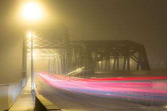
The Old Skeena Bridge officially opened July 1925, halting the use of the Ferry Island ferry service to Thornhill Creek. In 1944, the Skeena River Highway between Terrace and Prince Rupert was ceremoniously opened with a convoy of Canadian and American army bands that were part of the troops stationed there during World War II. Terrace could now easily transport to anywhere in British Columbia.
During the construction of the rail line to Kitimat in the early 1950s, new pilings were poured beside the existing structure and the bridge deck was moved to the new, higher pilings. The original pilings were then used to hold a new rail bridge across the Skeena River for the CNR line to Kitimat. This arrangement is still in place today.
This bridge now shares its load with the Dudley Little Bridges (often referred to as the New Skeena Bridges), a series of two two-way bridges crossing both channels of the Skeena River at Ferry Island and creating a bypass route of downtown Terrace for Highway 16. The new bridges, constructed circa 1975, are fully paved and offer uninterrupted two-way traffic flow, as opposed to the old single-lane bridge controlled by traffic lights. The foundations of the new bridge are prepared for future twinning. The Old Skeena Bridge was once noted for being the largest curved wooden-plank bridge in North America until its decking was replaced with metal grate decking in 2002 due to concerns of safety and upkeep. A concrete-surfaced pedestrian section was installed at the same time, behind an existing divider, to allow for safe bicycle and pedestrian use of the structure with the removal of the solid wooden deck planks.
Pastimes
During the summer, Terrace offers many outdoor activities, such as fishing for a wide range of freshwater fish, mountain biking, hiking, kiting and hunting in the surrounding areas. In the fall, many of Terrace's inhabitants go out to search for pine mushrooms (Tricholoma magnivelare), and pick berries. There is a variety of winter sports available in Terrace and the surrounding region including skiing and snowboarding at nearby Shames Mountain, as well as snowmobiling, ice fishing, curling, and ice skating.
Terrace Mutiny
During World War II, military units composed primarily of conscripts from central and eastern Canada were stationed in Terrace. Morale was low due to the poor relationship between the soldiers and the local populace, the isolation, the damp weather, lack of recreation, crowded facilities, and the distance from home. In late 1944, because of declining enlistment and heavy casualties, Prime Minister William Lyon Mackenzie King was forced to reconsider his promise to not deploy conscripts overseas. Mackenzie King decided to a one-time assignment of conscripts for overseas service. On November 24, 1944, news that conscripts might be sent overseas triggered a mutiny amongst the men stationed in Terrace. It took until November 29 for officers to restore order to the troops. The Terrace Mutiny was the most serious breach of discipline in Canadian military history.
Geography
Terrace and the surrounding Skeena Valley are located in a hybrid coastal-interior rainforest (coastal western hemlock wet submaritime according to the provincial Biogeoclimatic Ecosystem Classification Program[5]) on the Skeena River, approximately 115 kilometres (71 mi) from its mouth at the Pacific Ocean. The lush forests in the area consist primarily of western red cedar, western hemlock, amabilis fir or "balsam" and Sitka spruce. Sediment deposits from glaciers thousands of years ago have produced the natural terraces or "benches" around much of the city, which sits approximately 70 metres (230 ft) above sea level and just east of the Skeena and Kitsumkalum rivers' confluence. The dominant soil in Terrace is a well drained sandy loam with classic podzol profile development where the original forest remains.[6] The Hazelton Mountains are to the east of the city, while the Kitimat Ranges of the Coast Mountains are to the west. The area sits above an active fault line that runs north-south. The area also boasts several natural and developed hotsprings. Port Edward and Prince Rupert are respectively 136 km (85 mi) and 144 km (89 mi) to the west of Terrace, while Smithers and Prince George are respectively 203 km (126 mi) and 571 km (355 mi) to the east. Kitimat is 63 km (39 mi) to the south. Kitwanga and New Hazelton are 93 km (58 mi) and 136 km (85 mi) to the north east of Terrace respectively.
Climate
Being close to the Pacific Coast, Terrace has a humid continental climate (Köppen climate classification Dfb), with wet, cold winters (though much milder than inland places) and drier, warm summers, with an annual normal mean temperature of 6.3 °C (43.3 °F) varying between average temperature in January of −4.3 °C (24.3 °F) and in July 16.4 °C (61.5 °F). Maximum summer temperatures are around 31 °C (88 °F), but 36.2 °C (97.2 °F) has been recorded.
Terrace receives an average annual rainfall of 970.1 mm (38.19 in) and snowfall of 375.4 cm (147.80 in), water equivalence of 375.4 mm (14.78 in); totaling 1,322 mm (52.05 in) of precipitation, which is enough to sustain the lush vegetation of the area. October to February are the wettest months. Predominant winds are from the west and southwest, but occasional northerners during the winter bring snow in.[7]
| Climate data for Northwest Regional Airport | |||||||||||||
|---|---|---|---|---|---|---|---|---|---|---|---|---|---|
| Month | Jan | Feb | Mar | Apr | May | Jun | Jul | Aug | Sep | Oct | Nov | Dec | Year |
| Record high humidex | 8.4 | 12.6 | 16.4 | 28 | 34.6 | 38 | 39.3 | 38.5 | 34.1 | 23.3 | 14.5 | 12.5 | 39.3 |
| Record high °C (°F) | 9.4 (48.9) |
12.7 (54.9) |
16.9 (62.4) |
26 (79) |
34.6 (94.3) |
36.5 (97.7) |
37.3 (99.1) |
36.2 (97.2) |
32.2 (90) |
21.4 (70.5) |
13.4 (56.1) |
11.3 (52.3) |
37.3 (99.1) |
| Average high °C (°F) | −1.1 (30) |
1.7 (35.1) |
5.8 (42.4) |
10.8 (51.4) |
15.7 (60.3) |
19.1 (66.4) |
21.4 (70.5) |
21.1 (70) |
16 (61) |
9 (48) |
2.6 (36.7) |
−0.8 (30.6) |
10.1 (50.2) |
| Daily mean °C (°F) | −3 (27) |
−0.9 (30.4) |
2.4 (36.3) |
6.3 (43.3) |
10.6 (51.1) |
14.2 (57.6) |
16.5 (61.7) |
16.3 (61.3) |
12.1 (53.8) |
6.4 (43.5) |
0.7 (33.3) |
−2.6 (27.3) |
6.6 (43.9) |
| Average low °C (°F) | −5 (23) |
−3.4 (25.9) |
−1.1 (30) |
1.7 (35.1) |
5.5 (41.9) |
9.2 (48.6) |
11.6 (52.9) |
11.5 (52.7) |
8.2 (46.8) |
3.7 (38.7) |
−1.1 (30) |
−4.5 (23.9) |
3 (37) |
| Record low °C (°F) | −25 (−13) |
−25 (−13) |
−19.4 (−2.9) |
−8.3 (17.1) |
−2.2 (28) |
0.6 (33.1) |
3.3 (37.9) |
2.8 (37) |
−1.4 (29.5) |
−13.5 (7.7) |
−25.3 (−13.5) |
−26.7 (−16.1) |
−26.7 (−16.1) |
| Record low wind chill | −40.8 | −35.9 | −30.3 | −14.5 | −6.1 | 0 | 0 | 0 | −4.4 | −24 | −41.7 | −42.2 | −42.2 |
| Average precipitation mm (inches) | 173.5 (6.831) |
110.6 (4.354) |
92.3 (3.634) |
73.7 (2.902) |
56.4 (2.22) |
50.8 (2) |
52.8 (2.079) |
61.2 (2.409) |
111.5 (4.39) |
190.3 (7.492) |
187.1 (7.366) |
180.9 (7.122) |
1,340.8 (52.787) |
| Average rainfall mm (inches) | 91.7 (3.61) |
61.8 (2.433) |
58.8 (2.315) |
64.7 (2.547) |
55.7 (2.193) |
50.8 (2) |
52.8 (2.079) |
61.2 (2.409) |
111.5 (4.39) |
185.2 (7.291) |
132.2 (5.205) |
99 (3.9) |
1,025.3 (40.366) |
| Average snowfall cm (inches) | 88.4 (34.8) |
51.9 (20.43) |
34.3 (13.5) |
8.5 (3.35) |
0.4 (0.16) |
0 (0) |
0 (0) |
0 (0) |
0 (0) |
4.8 (1.89) |
56 (22) |
87.1 (34.29) |
331.5 (130.51) |
| Average precipitation days (≥ 0.2 mm) | 20.6 | 15.3 | 17.5 | 15.4 | 14.8 | 14.7 | 14.1 | 13.4 | 16.6 | 21.8 | 21.9 | 20.9 | 206.8 |
| Average rainy days (≥ 0.2 mm) | 11.7 | 10 | 13.3 | 14.4 | 14.8 | 14.7 | 14.1 | 13.4 | 16.6 | 21.7 | 16.8 | 11.1 | 172.4 |
| Average snowy days (≥ 0.2 cm) | 14.6 | 9.7 | 8.9 | 3.2 | 0.4 | 0 | 0 | 0 | 0 | 1.5 | 11.4 | 15.6 | 65.1 |
| Average relative humidity (%) | 79.9 | 72.3 | 63.9 | 54.1 | 50.5 | 51.6 | 53.7 | 55.2 | 65.3 | 78.2 | 84.3 | 83.5 | 66 |
| Mean monthly sunshine hours | 46.8 | 74.1 | 110.7 | 159.3 | 201.3 | 203.3 | 214.4 | 203 | 132.2 | 73.4 | 36.5 | 31.5 | 1,486.5 |
| Percent possible sunshine | 19 | 27.1 | 30.2 | 37.8 | 40.5 | 39.5 | 41.6 | 43.9 | 34.5 | 22.4 | 14.2 | 13.7 | 30.4 |
| Source: [8] | |||||||||||||
Demographics
| Canada 2011 Census | Population | % of total population | |
|---|---|---|---|
| Visible minority group Source:[9] |
South Asian | 385 | 3.4% |
| Chinese | 60 | 0.5% | |
| Black | 15 | 0.1% | |
| Filipino | 125 | 1.1% | |
| Latin American | 10 | 0.1% | |
| Arab | 0 | 0% | |
| Southeast Asian | 20 | 0.2% | |
| West Asian | 0 | 0% | |
| Korean | 0 | 0% | |
| Japanese | 30 | 0.3% | |
| Other visible minority | 0 | 0% | |
| Mixed visible minority | 0 | 0% | |
| Total visible minority population | 670 | 5.9% | |
| Aboriginal group Source:[10] | First Nations | 2,110 | 18.7% |
| Métis | 305 | 2.7% | |
| Inuit | 20 | 0.2% | |
| Total aboriginal population | 2,560 | 22.6% | |
| Caucasians | 8,080 | 71.4% | |
| Total population | 11,310 | 100% | |
Economy
Terrace was once the cedar pole capital of the world. Over 50,000 poles were manufactured annually to supply many parts of North America with telephone and electric power poles. The world's tallest pole, 50 metres (160 ft) long, was cut in Terrace and stands in New York City. For many years, logging was the region's major industry, but Terrace's economy has recently been forced to diversify since nearly all wood mills not operated by First Nations groups have closed down. Terrace's largest employers are in the public sector, but there are still some large private employers. Many people in Terrace commute to Kitimat to work at Alcan. The city has continually tried to reinvent itself as a service hub for northwestern British Columbia.
In 2001, the community was significantly affected by problems with and the eventual closure of the largest local employer, the former Skeena Cellulose Inc. sawmill. The mill was bought by Terrace Lumber Co., a group of local owners, and reopened in late August 2005, but did not prosper and closed in mid-2006. By the end of 2006, the remaining equipment was auctioned off and the mill was torn down. The mill's former site is now a vacant lot with its footings covered in graffiti.
Current economic prospects are linked to tourism, mineral developments to the north and northwest, construction of a power line towards Iskut and energy-related developments in Kitimat. The Prince Rupert container port expansion has resulted in increased rail traffic by CN Rail in recent years. In 2004, a Wal-Mart center was built in Terrace (store 5834). The Skeena mall underwent a large-scale renovation that was completed in 2013. The ski resort Northern Escape Heli-skiing is based in Terrace.
Educational institutions
Terrace is in School District 82 Coast Mountains, along with Kitimat, Stewart, and Hazelton. There is one senior secondary school in Terrace, Caledonia Senior Secondary School,[11] which serves grades 10, 11 and 12. Terrace is also home to a distance education school, North Coast Distance Education School, which serves all grades from kindergarten to grade 12 and adults. There is one middle school, Skeena Middle School, and one public Francophone primary school, école Jack-Cook, operated by the Conseil scolaire francophone de la Colombie-Britannique.[12] Centennial Christian School is also within the town limits, and provides classes from preschool to grade 12.
The main campus of the Northwest Community College[13] is in Terrace, where it was established in 1975. The college includes the Freda Diesing School, which offers courses related to First Nations art.
The University of Northern British Columbia (UNBC)[14] has a regional campus at 4837 Keith Avenue, the Northwest Regional (Terrace) Campus {http://www.unbc.ca/about/campus/northwest.html}. An additional campus is in Prince Rupert, housed in the NWCC building.
Media
Newspaper
Radio
- AM 590 - CFTK, adult contemporary
- FM 92.1 - CFNR-FM, First Nations community / classic rock
- FM 95.3 - CBTH-FM, CBC Radio One (repeats CFPR, Prince Rupert)
- FM 96.9 - CBUF-FM-3, Première Chaîne (repeats CBUF-FM, Vancouver)
- FM 103.1 - CJFW-FM, country
Television
Bibliography
- Bennett, Norma (1997). Pioneer Legacy: Chronicles of the Lower Skeena River. Dr. REM Lee Hospital Foundation. ISBN 0-9683026-0-2.
- Downs, Art (1971). Paddlewheels on the Frontier. one. ISBN 0-88826-033-4.
- de Leeuw, Sarah. "Unmarked". Unmarked: Landscapes Along Highway 16.
Footnotes
- ↑ Population and dwelling counts, for Canada, provinces and territories, and population centres, 2011 and 2006 censuses: British Columbia. Statistics Canada. Retrieved March 17, 2013
- ↑ Downs, Art (1971). Paddlewheels on the Frontier Volume 1. Foremost Publishing. pp. 61–72. ISBN 0-88826-033-4.
- ↑ Bennett, Norma (1997). Pioneer Legacy: Chronicles of the Lower Skeena River. Dr. REM Lee Hospital Foundation. ISBN 0-9683026-0-2.
- ↑ Terrace Library, George Little Family page
- ↑ http://www.for.gov.bc.ca/hre/becweb/
- ↑ http://sis.agr.gc.ca/cansis/publications/surveys/bc/bc4/bc4_report.pdf
- ↑ Environment Canada—Canadian Climate Normals 1971–2000, accessed 24 July 2012
- ↑ "Calculation Information for 1981 to 2010 Canadian Normals Data". Environment Canada. Archived from the original on June 14, 2013. Retrieved July 9, 2013.
- ↑ "Community Profiles from the 2011 Census, Statistics Canada - Census Subdivision". 2.statcan.gc.ca. 2010-12-06. Retrieved 2013-04-13.
- ↑ "Aboriginal Peoples - Data table". 2.statcan.ca. 2010-10-06. Retrieved 2013-04-13.
- ↑
- ↑ "Carte des écoles." Conseil scolaire francophone de la Colombie-Britanique. Retrieved on 22 January 2015.
- ↑ http://www.nwcc.bc.ca
- ↑ http://www.unbc.ca
External links
| Preceded by Roberval, Quebec |
Kraft Hockeyville 2009 |
Succeeded by Dundas, Ontario |
| Subdivisions |  | |
|---|---|---|
| Communities | ||
| Metro areas and agglomerations | ||
| Cities |
| |
| ||