Port Alberni
| Port Alberni | |
|---|---|
| City | |
| City of Port Alberni | |
|
Aerial view of Port Alberni | |
| Motto: Gateway to the Pacific West Coast | |
 Port Alberni Location of Port Alberni in British Columbia | |
| Coordinates: 49°14′2″N 124°48′18″W / 49.23389°N 124.80500°WCoordinates: 49°14′2″N 124°48′18″W / 49.23389°N 124.80500°W | |
| Country | Canada |
| Province | British Columbia |
| Region | Alberni-Clayoquot Regional District |
| Incorporated | 1912 |
| Government | |
| • Mayor | Mike Ruttan |
| • Governing body | Port Alberni City Council |
| Area | |
| • Total | 19.76 km2 (7.63 sq mi) |
| Population (2011) | |
| • Total | 17,743 |
| • Density | 897.9/km2 (2,326/sq mi) |
| Time zone | PST (UTC-8) |
| Postal code span | V9Y |
| Area code(s) | 250, 778 |
| Highways | Highway 4 |
| Waterways | Sproat Lake, Alberni Inlet |
| Climate | Csb |
| Website | portalberni.ca |
|
| |

Port Alberni is a city located on Vancouver Island in the province of British Columbia, Canada.
Port Alberni has a total population of 17,743, and a census agglomeration area of 25,396.
Port Alberni is a deep port city which lies within the Alberni Valley at the head of the Alberni Inlet, Vancouver Island's longest inlet. It is the location of the head offices of the Alberni-Clayoquot Regional District.
History
Port Alberni was named for Captain Pere d'Alberní,[1] a Spanish officer, who commanded Fort San Miguel at Nootka Sound on Vancouver Island's west coast from 1790 to 1792.
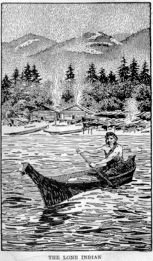
Before Europeans came, Alberni and the West Coast of Vancouver Island was the traditional territory of the Tseshaht and Hupacasath First Nations of the Nuu-Chah-Nulth Tribal Council. The Nuu-chah-nulth were previously called the Nootka. Many place names in Port Alberni have a Nuu-chah-nulth origin, such as Somass (washing), Kitsuksis (log across mouth of creek), Pacheena (foamy), and Nootka (go around). Ancient petroglyph carvings can be found at Sproat Lake.
In March 1787, Captain Charles William Barkley of the Imperial Eagle, explored Barkley Sound, which now bears his name. Barkley travelled with his 17-year-old bride, Frances Barkley, the first European woman to visit what is now British Columbia. Frances Barkley is also the name of one of the two vessels that makes trips down the Alberni Inlet from Port Alberni to Bamfield and Ucluelet. The other, since retired, was the MV Lady Rose.
In 1856, Adam Horne, a Scottish fur trader employed by the Hudson's Bay Company, was directed to locate a land route across Vancouver Island. There were stories that the natives used a trail starting at Qualicum. Adam Horne found this trail leading to the Alberni Valley and it became known as the Horne Lake Trail. Many other settlers used this trail to get to the Alberni Valley.

In 1860, the Anderson company (a sawmilling company) from London England, took the advice of their Victoria agent Captain Edward Stamp and set up a sawmill operation. At the time, the American Civil War prevented the importation of timber from the southern United States. Gilbert Sproat and Edward Stamp transported men and machinery to Alberni. They received land grants from Governor James Douglas and started running the Anderson sawmill at the mouth of the Somass River in August 1861. The first mill in B.C. was built to export lumber. The original mill failed, but several others were established in the 1880s. Sproat Lake was named after Gilbert Sproat and Stamp Falls and Stamp River were named after Edward Stamp.
Rogers Creek, which flows through the centre of Port Alberni, was named after A.B. Rogers,the discoverer of Rogers Pass, when he surveyed in the Alberni Valley for the Canadian Pacific Railway in the late 19th century.
In 1862, small-scale placer gold mining took place on China Creek; in the 1890s more gold mining took place along the Alberni Inlet at China Creek and Mineral Creek. Several gold veins were found. Exploration for gold continued over the years with peaks in the 1930s and 1960s.
In 1912, Port Alberni was incorporated with the arrival of the Esquimalt and Nanaimo Railway, and planned arrival of the Canadian National Railway, and the trans-Pacific telegraph cable at Bamfield. Mining took place on the Alberni Inlet and, as with many fish camps and outports, depended on Port Alberni as a base.
With ample western red cedar and Douglas fir forests surrounding the valley, the forest industry became the dominant economic force. Large logging operators moved in, namely Bloedel, Stewart and Welch. Sawmills were built at Alberni, Great Central Lake, and the McLean Mill. By the Second World War, plywood mills and a nascent pulp industry had started. For the next forty years, the forest industry reigned supreme. Port Alberni Mill opened as a kraft pulp mill in 1946, followed by two paper machines in 1957.[2]
Today, the town is a major service centre for local, regional, and provincial governments, and a supply centre and hospital for west coast communities like Bamfield, Tofino, and Ucluelet. Currently, the natural resources of the area are taking centre stage again, but in a different way. Port Alberni is in the process of "re-developing" itself as a tourism destination. The area's amenities, such as the natural beauty of the area, the opportunities for fishing (both marine and freshwater), its convenience as a jumping-off point for new outdoor recreation and ecotourism activities such as hiking, kayaking, and mountain-biking, lend themselves to these activities very well.

The 1946 Vancouver Island earthquake was a 7.3 magnitude earthquake that struck at 10:15 a.m. on Sunday, June 23, 1946.[3] The main shock epicenter occurred in the Forbidden Plateau area north of Port Alberni. While most of the large earthquakes in the Vancouver area occur at tectonic plate boundaries, the 1946 Vancouver Island earthquake was a crustal event.[4] Shaking was felt from Portland, Oregon to Prince Rupert, British Columbia. The earthquake is remembered as one of the most damaging earthquakes in the history of British Columbia.
From 1920 to 1973 Alberni Residential School was in operation. The Canadian Federal government now says that this was a big blot on race relations in Canada.[5] The residential school system run by the United Church forcibly separated children from their families and communities. The residential school was closed in the late 1970s and in 2009 was demolished.
In 1955, the Alberni Athletics Senior-A Men's Basketball Team had an outstanding year. The Alberni Athletics won the Canadian Senior Basketball Championships at home. A young Jim Robson honed his sports reporting skills doing the play-by-play on radio station CJAV. The Alberni Athletics were inducted into the BC Sports Hall of Fame in 2001.

In 1964, Port Alberni was hit by two tsunamis (called tidal waves in 1964) during the Good Friday earthquake. The water rose about one foot in a minute reaching ten feet above the high-water mark. About 375 homes were damaged and 55 were washed away, however there were no injuries or fatalities.
In 1967, the neighbouring towns of Alberni (on the north) and Port Alberni (on the south) amalgamated to form the city of Port Alberni.
The Alberni Valley has a museum and many ancillary attractions. Sproat Lake, located just outside Port Alberni.
Geography
Located at the head of the Alberni Inlet, Port Alberni lies adjacent to this natural harbour as well as the Somass River. The other end of the inlet is located on Barkley Sound, which includes the Broken Group Islands, considered to be one of the best areas for kayaking in the world.[6]Sproat lake is located 10 km west of the city, and the valley is guarded by the snow-covered peaks of the Beaufort range, Mount Arrowsmith and Mount Klitsa, and surrounded by mountains on all sides. Kuth-kah-chulth, is the Nuu-Chah-Nulth name for Mount Arrowsmith.

The city itself owes its unique layout to its former "twin city" status, due to its two official city centres, as well as the numerous creeks and ravines that bisect the townsite. The former city of Alberni is now dubbed "North Port", and is centered at Highway 4 and Gertrude Street. Visitors continuing onward to the west coast will pass this intersection, marked by the historic Alberni Post Office on the Southeast corner. Much of Port Alberni's recent development has occurred in the North Port area, especially "up the hill", east of the North Port downtown.
The former City of Port Alberni (now referred to as "South Port" or "Uptown") can be found about 3 km South on 3rd and Argyle street. In 2004, the Capitol Theatre, a local landmark in South Port, underwent extensive renovations and emerged as a stately yet modern relic of past times. This theatre now often hosts live performances. South Port is anchored by the Harbour Quay, a waterfront collection of shops, art galleries, great food and parks. The Port Alberni railway station, farmers market on Saturdays, as well as the Maritime Discovery Centre can be found here.
The city's West End is an eclectic mix of new suburban style homes, large acreages, and two First Nations reserves. Much of the residential growth over the past decade has occurred in the city's West End, where the Westporte neighbourhood has taken shape.
The creeks and ravines that cut through the city create natural barriers; Kitsuksis Creek, Cherry Creek, Roger Creek and Dry Creek each flow through the city. The hiking trails in these creeks and ravines add tremendously to the quality of life in Port Alberni.
Climate
Port Alberni's dry July gives it a warm-summer Mediterranean climate (Koppen Csb), although it is much wetter than most such places. Although the summer months do see a relatively small amount of precipitation, the vast majority of it comes during the winter months as cool, moist air flows from the Pacific Ocean over the much colder B.C. coast. Despite its location on the relatively dryer east side of Vancouver Island, the resulting weak rain shadow is not enough to keep the city dry.
The highest temperature ever recorded in Port Alberni was 106 °F (41.1 °C) on 15 July 1941.[7] The coldest temperature ever recorded was −7 °F (−21.7 °C) on 14 January 1950.[8]
| Climate data for Port Alberni Airport, 1981–2010 normals, extremes 1917–present[lower-alpha 1] | |||||||||||||
|---|---|---|---|---|---|---|---|---|---|---|---|---|---|
| Month | Jan | Feb | Mar | Apr | May | Jun | Jul | Aug | Sep | Oct | Nov | Dec | Year |
| Record high °C (°F) | 15.6 (60.1) |
19.4 (66.9) |
24.2 (75.6) |
30.6 (87.1) |
34.1 (93.4) |
37.2 (99) |
41.1 (106) |
39.4 (102.9) |
35.6 (96.1) |
27.8 (82) |
20.6 (69.1) |
16.7 (62.1) |
41.1 (106) |
| Average high °C (°F) | 5.4 (41.7) |
7.4 (45.3) |
11.5 (52.7) |
14.2 (57.6) |
18.0 (64.4) |
20.7 (69.3) |
24.2 (75.6) |
25.5 (77.9) |
22.3 (72.1) |
14.9 (58.8) |
8.1 (46.6) |
4.5 (40.1) |
14.7 (58.5) |
| Daily mean °C (°F) | 3.0 (37.4) |
3.8 (38.8) |
6.4 (43.5) |
8.7 (47.7) |
12.0 (53.6) |
14.9 (58.8) |
17.4 (63.3) |
18.0 (64.4) |
14.9 (58.8) |
10.0 (50) |
5.3 (41.5) |
2.4 (36.3) |
9.7 (49.5) |
| Average low °C (°F) | 0.5 (32.9) |
0.1 (32.2) |
1.3 (34.3) |
3.2 (37.8) |
6.1 (43) |
8.9 (48) |
10.6 (51.1) |
10.5 (50.9) |
7.5 (45.5) |
5.1 (41.2) |
2.5 (36.5) |
0.4 (32.7) |
4.7 (40.5) |
| Record low °C (°F) | −21.7 (−7.1) |
−15.6 (3.9) |
−13.9 (7) |
−7.8 (18) |
−5.6 (21.9) |
0.0 (32) |
2.2 (36) |
1.1 (34) |
−3.9 (25) |
−8.5 (16.7) |
−16.8 (1.8) |
−17.4 (0.7) |
−21.7 (−7.1) |
| Average precipitation mm (inches) | 290.9 (11.453) |
255.3 (10.051) |
190.1 (7.484) |
126.6 (4.984) |
78.5 (3.091) |
55.3 (2.177) |
26.1 (1.028) |
38.5 (1.516) |
49.1 (1.933) |
204.4 (8.047) |
316.6 (12.465) |
276.0 (10.866) |
1,907.3 (75.091) |
| Average rainfall mm (inches) | 275.7 (10.854) |
234.6 (9.236) |
180.6 (7.11) |
125.6 (4.945) |
78.5 (3.091) |
55.3 (2.177) |
26.1 (1.028) |
38.5 (1.516) |
49.1 (1.933) |
203.3 (8.004) |
305.9 (12.043) |
255.9 (10.075) |
1,829 (72.008) |
| Average snowfall cm (inches) | 15.4 (6.06) |
22.2 (8.74) |
10.1 (3.98) |
1.0 (0.39) |
0.0 (0) |
0.0 (0) |
0.0 (0) |
0.0 (0) |
0.0 (0) |
1.1 (0.43) |
9.6 (3.78) |
20.7 (8.15) |
80.0 (31.5) |
| Average precipitation days (≥ 0.2 mm) | 20.0 | 17.3 | 17.7 | 17.9 | 14.5 | 12.4 | 6.7 | 6.9 | 8.6 | 15.6 | 21.6 | 19.6 | 178.5 |
| Average rainy days (≥ 0.2 mm) | 18.4 | 15.2 | 17.2 | 17.9 | 14.5 | 12.4 | 6.7 | 6.9 | 8.6 | 15.5 | 21.0 | 17.1 | 171.3 |
| Average snowy days (≥ 0.2 cm) | 3.4 | 3.6 | 2.6 | 0.5 | 0.0 | 0.0 | 0.0 | 0.0 | 0.0 | 0.1 | 1.9 | 5.1 | 17.2 |
| Average relative humidity (%) (at 15:00 LST) | 88.3 | 77.5 | 65.8 | 58.6 | 59.4 | 57.7 | 52.7 | 47.7 | 52.5 | 70.8 | 83.6 | 87.5 | 66.8 |
| Mean monthly sunshine hours | 24.3 | 58.1 | 111.8 | 150.5 | 191.4 | 193.8 | 262.8 | 262.6 | 195.8 | 103.1 | 35.0 | 22.1 | 1,611.2 |
| Percent possible sunshine | 9.0 | 20.4 | 30.4 | 36.6 | 40.3 | 40.0 | 53.7 | 58.8 | 51.6 | 30.7 | 12.7 | 8.6 | 32.8 |
| Source: Environment Canada[9][10][11][12] | |||||||||||||
Demographics
The total population of Port Alberni and surrounding suburbs consisting of both Cherry and Beaver Creek districts is 26,569 (as of the 2004 census conducted by Statistics Canada). The median household income in 2005 for Port Alberni was $43,624.
One major characteristic known is the twin city demographic, where previously there were the distinct Port Alberni and Alberni municipalities, the remnants remain with two distinct city centres.
| Canada 2006 Census | Population | % of Total Population | |
|---|---|---|---|
| Visible minority group Source:[13] | Chinese | 120 | 0.7% |
| South Asian | 665 | 3.8% | |
| Black | 45 | 0.3% | |
| Filipino | 20 | 0.1% | |
| Latin American | 50 | 0.3% | |
| Southeast Asian | 10 | 0.1% | |
| Arab | 11 | 0% | |
| West Asian | 0 | 0% | |
| Korean | 0 | 0% | |
| Japanese | 35 | 0.2% | |
| Other visible minority | 0 | 0% | |
| Mixed visible minority | 35 | 0.2% | |
| Total visible minority population | 980 | 5.7% | |
| Aboriginal group Source:[14] | First Nations | 2,050 | 11.8% |
| Métis | 0 | 0% | |
| Inuit | 0 | 0% | |
| Total Aboriginal population | 2,050 | 11.8% | |
| European Canadian | 14,295 | 82.5% | |
| Total population | 17,336 | 100% | |
Health and education
Public education is offered by School District 70 Alberni, which operates 11 schools in Port Alberni. New multimillion-dollar state of the art high school opened in 2012-2013.
The Conseil scolaire francophone de la Colombie-Britannique operates one Francophone primary school: école des Grands-cèdres.[15]
Health services are provided in town by Westcoast General Hospital, operated by the Vancouver Island Health Authority (VIHA).[16]
Economy
The chief source of employment in Port Alberni is the forest industry. The Alberni Valley's forests consist primarily of Douglas fir, hemlock, yellow cedar and western red cedar. Most of the old growth forests have been logged with current logging coming from second growth forests. Port Alberni Mill, owned by Catalyst Paper, sits on the edge of the Alberni Inlet. It produces 340,000 tonnes of directory paper and lightweight coated paper each year.[17] There is also a lumber mill, Alberni Pacific Division, that also sits on the inlet. Several smaller sawmills exist throughout the valley. Farming is also practised in the valley.
Port Alberni also serves as a hub for those travelling to the West Coast of Vancouver Island, including Ucluelet, Tofino and Pacific Rim National Park. As commodities tend to be much pricier in these remote areas, campers and travellers often do their shopping in Port Alberni before continuing their journey. This has resulted in development along the Johnston Road (Highway 4) corridor, including several big box retailers, grocery stores and strip mall developments. Previously, eco-tourism companies have set up shop in the Alberni Valley, taking advantage of the city's location on the fringe of wilderness yet proximate location to Vancouver and Victoria. For example, there's a kayaking, ATV touring, a windsurfing and a glider company.
Salmon
In the past two years Port Alberni’s Sockeye salmon returns have been the largest in recorded history, topping the 1.4 million mark both years. The two primary spawning lakes, Great Central and Sproat, saw over 800,000 Sockeye return. Chinook and Coho salmon returns have been average to good, providing anglers with great salmon fishing from early June through September in the saltchuck and all year round in the lakes and rivers. A team of salmon enhancement volunteers and the Department of Fisheries and Oceans have been improving salmon habitat throughout the Alberni Valley, adding a Coho hatchery at the McLean Mill National Historic Site, in addition to the highly successful Robertson Creek Hatchery on the Stamp River. Port Alberni was awarded the World Fishing Network’s coveted “Ultimate Fishing Town” designation in 2010.
Attractions
Port Alberni sits beneath Mount Arrowsmith and is almost completely surrounded by mountains. These beautiful mountains provide great hiking, walking, and mountain biking trails. It also provides the rare opportunity to view wildlife, including deer and black bears.
The city is also known for its fishing. Its waters contain five different species of salmon and yearly runs of steelhead. Halibut can also be found in the saltwater inlets near the city.
The state-of-the-art Robertson Creek Fish Hatchery is the most successful hatchery on Vancouver Island, producing chinook salmon, coho salmon, and steelhead smolts. It is located a short drive west of Port Alberni.[18] and is open to the public.
Port Alberni is home to the McLean Mill National Historic Site which incorporates a steam railway from the downtown harbour to the saw mill up the valley.[19] The historic mill offers demonstrations, including operating the old mill.
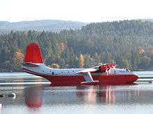
The world's largest aerial firefighting flying boats, the Martin Mars Water Bombers, once made their home on nearby Sproat Lake. This lake is also a popular summer destination for local residents and cottagers from surrounding areas. The sole remaining Water Bomber is now owned by The Coulson Group, and has been renamed from the Martin Mars Water Bombers to the Coulson Flying Tankers. The provincial lake also provided petroglyphs carved First Nations many years ago.
Besides the offers from nature, the city has two quays, Harbour Quay and Victoria Quay include shops, restaurants, and art galleries along the inlet. In addition, at the Victoria Quay the fall, during dusk and low tide in the inlet, black bears can be viewed walking along the other side of the quay looking for fish.
The Alberni Valley Multiplex in Port Alberni is home to the Alberni Valley Bulldogs, a Junior-A hockey team in the BCHL.
Della Falls, the tallest falls (442m) in Canada, is accessible by boat from Great Central Lake or by helicopter. Helicopters are not allowed to land in Strathcona Provincial Park.
Hiking trails around Port Alberni
Port Alberni has some of the best hiking on Vancouver Island. There are over 100 trails in and around the Alberni Valley, including mountain bike trails for all abilities. There is easy quick access to the alpine areas, including Mount Arrowsmith.
- Horne Lake Trail
- Log Train Trail
- Angler's Trail at Stamp River
- Rogers Creek Trail
- Inlet Trail
- Labour Day Lake Trail
- Greenmax Anglers Trail
- China Creek Trail
- Climb Mount Arrowsmith
- Della Falls Trail
- Kitsukis Dyke Walking Path
- Old Forestry Lookout Trail
- Saddle Trail on Mount Arrowsmith
Transportation
Port Alberni Airport (CBS8) is located 11 km north west of the city. The airport has a 4,000-foot runway with another 2,500 plus feet of taxiways and apron. The airport is home to a number of key tenants, including Coulson Aircrane, Canadian Aero Technologies, Alberni Valley Flying Club and Vancouver Island Helicopters.
The Port Alberni Port Authority was created in 1999. Under the Canada Marine Act, the Port Alberni Port Authority is responsible for the Alberni Inlet from the Somass River[20] to Tzartus Island.[21]
The main highway to Port Alberni is Highway 4, known locally as the Alberni Highway and the Pacific Rim Highway. It is the longest east-west main vehicle route on Vancouver Island, with a total length of 163 km (101 mi). The highway to Port Alberni was completed in 1942, and has been designated as Highway 4 since 1953. The highway starts at Qualicum Beach, then reaches Port Alberni from which it continues on to Tofino and Ucluelet.
Port Alberni was served by the Southern Railway of Vancouver Island. The train track to Port Alberni requires extensive upgrading and trains have not come to Port Alberni since the early 2000s.
Notable residents
- Paul Boyd, Canadian and American television journalist (Inside Edition)
- Laurent Brossoit, NHL player with the Edmonton Oilers
- Kim Campbell, 19th Prime Minister of Canada from 25 June to 4 November 1993; the first woman to hold this office.
- George Clutesi (1905-1988) became a Tseshaht artist, actor and writer as well as an expert on and spokesman for First Nations cultures. In 1959, he received the British Columbia Centennial Award and the Canada Centennial Medal in 1967.[22] He was commissioned to paint a mural for Expo 67. Emily Carr was so impressed with his work that in her will she left him her brushes, oils and unused canvases. He died in Victoria in 1988.
- Travis Cross, Olympic wrestler
- Paul Cyr, drafted into the NHL by the Buffalo Sabres in the first round (9th overall) in 1982.
- David Dziurzynski, Ottawa/ Binghamton Senators NHL/ AHL forward.
- Rick Hansen, Canadian paraplegic athlete and activist for people with spinal cord injuries who is most famous for his Man in Motion world tour to raise money for the cause and show the physical capabilities of such people.
- Jim Hiller, current assistant coach of the National Hockey League's Toronto Maple Leafs.[23]
- Eric Jespersen, bronze medalist at the 1992 Olympics
- Jamie Lowery, former soccer player and member of Canada's national team at the 1986 World Cup.
- Dakota Morton, youngest Canadian radio host; created the record and set it on January 16, 1999 at the age of 10 years 218 days. Record was awarded while Dakota was hosting his radio show at CJAV radio in Port Alberni.
- Kenneth Oppel, Canadian writer of the Silverwing & Matt Cruse series.[24]
- Davis Payne, current associate coach of Stanley cup champion LA Kings
- Rob Shick, has been with the NHL as an official since September 1, 1984
- Alec Thomas, fisherman, trapper, longshoreman, logger, “anthropologist”, interpreter, and Tseshaht politician.[25]
- Scott Vickaryous, actor
- Harry Zolnierczyk, Philadelphia Flyers forward
See also
References
- ↑ Archer, Christon. "ALBERNI, PEDRO DE". Library and Archives Canada.
- ↑ Christie, Doug (1 January 2004). "Looking West: Historical Overview of the Industry in BC". Pulp and Paper Canada. Archived from the original on 9 July 2015. Retrieved 9 July 2015.
- ↑ The M7.3 Vancouver Island Earthquake of 1946 Retrieved on 2008-06-11
- ↑ 1946 Vancouver Island Earthquake Anniversary Retrieved on 2008-06-11
- ↑ Indian and Northern Affairs Canada
- ↑ Vancouverisland.com http://www.vancouverisland.com/Regions/towns/?townID=4013
- ↑ "Daily Data Report for July 1941". Environment Canada. Retrieved 30 August 2016.
- ↑ "Daily Data Report for January 1950". Environment Canada. Retrieved 30 August 2016.
- ↑ "Calculation Information for 1981 to 2010 Canadian Normals Data". Environment Canada. Retrieved July 9, 2013.
- ↑ "Port Alberni". Environment Canada. Retrieved 30 August 2016.
- ↑ "Port Alberni Redford". Environment Canada. Retrieved 30 August 2016.
- ↑ "Port Alberni (Aut)". Environment Canada. Retrieved 30 August 2016.
- ↑ "Community Profiles from the 2006 Census, Statistics Canada - Census Subdivision". 2.statcan.gc.ca. 2010-12-06. Retrieved 2013-04-13.
- ↑ "Aboriginal Peoples - Data table". 2.statcan.ca. 2010-10-06. Retrieved 2013-04-13.
- ↑ "Carte des écoles." Conseil scolaire francophone de la Colombie-Britanique. Retrieved on 22 January 2015.
- ↑ VIHA Central Island Facilities. Retrieved 2011-10-24
- ↑ "Our Mills: Port Alberni, BC" (PDF). Catalyst Paper. May 2014. Archived from the original on 9 November 2013. Retrieved 9 July 2015.
- ↑ Robertson Creek Fish Hatchery
- ↑ Alberni heritage
- ↑ Somass River
- ↑ Portalberni Portauthority
- ↑ Native American Authors: George Clutesi profile, October 9, 2007.
- ↑
- ↑ Guinness World Records 2005 Special 50th Anniversary Edition; ISBN 0-9735514-0-2
- ↑ Alec Thomas profile, tseshaht.com; accessed March 1, 2014.
- ↑ http://www.alberniweather.ca/port-alberni-theres-an-app-for-that-and-signing-off-for-a-couple-weeks/
- ↑ http://www.albernivalleynews.com/business/291185121.html
- ↑ http://www.avtimes.net/news/299889461.html
Notes
- ↑ Climate data was recorded at Port Alberni from July 1917 to December 1971 and at Port Alberni Airport from November 1969 to present.
External links
![]() Media related to Port Alberni at Wikimedia Commons
Media related to Port Alberni at Wikimedia Commons
- Community Profile: Port Alberni (City), British Columbia; Statistics Canada
- Community Profile: Port Alberni (Census Agglomeration), British Columbia; Statistics Canada
- Walkscore: Port Alberni: 49 Car Dependent
| Subdivisions |  | |
|---|---|---|
| Communities | ||
| Metro areas and agglomerations | ||
| Cities |
| |
| ||