Charaña Municipality
| Charaña Municipality | |
|---|---|
| Municipality | |
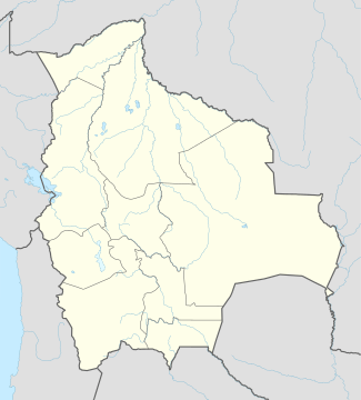 Charaña Municipality Location of the Charaña Municipality within Bolivia | |
| Coordinates: 17°35′0″S 69°10′0″W / 17.58333°S 69.16667°WCoordinates: 17°35′0″S 69°10′0″W / 17.58333°S 69.16667°W | |
| Country |
|
| Department | La Paz Department |
| Province | Pacajes Province |
| Seat | Charaña |
| Government | |
| • Mayor | Victor Hugo Apaza Mamani (2007) |
| • President | Eufracio Marca Cruz (2007) |
| Area | |
| • Total | 1,110 sq mi (2,876 km2) |
| Elevation | 13,500 ft (4,100 m) |
| Population (2001) | |
| • Total | 2,766 |
Charaña Municipality is the fifth municipal section of the Pacajes Province in the La Paz Department, Bolivia. Its seat is Charaña.
Geography
Some of the highest mountains of the municipality are listed below:[1][2][3][4]
- Ch'iyara Salla
- Jach'a Kunturiri
- Kunturiri
- K'illima Parki
- Laram Q'awa (Charaña)
- Laram Q'awa (Río Blanco)
- Phaq'u Q'awa
- Tatitu Qullu
- Wayra Lupi Qullu
Climate
The climate in Charaña is characterized by a sub-freezing mean annual temperature, with large annual temperature ranges, and moderately low precipitation. The Köppen Climate System classifies this as a Tundra climate, abbreviated as ET.[5]
| Climate data for Charaña_Municipality | |||||||||||||
|---|---|---|---|---|---|---|---|---|---|---|---|---|---|
| Month | Jan | Feb | Mar | Apr | May | Jun | Jul | Aug | Sep | Oct | Nov | Dec | Year |
| Average high °C (°F) | 17 (63) |
17 (62) |
17 (62) |
18 (64) |
17 (62) |
14 (58) |
14 (58) |
16 (60) |
16 (61) |
17 (63) |
19 (66) |
18 (64) |
17 (62) |
| Daily mean °C (°F) | 7 (45) |
7 (45) |
7 (45) |
5 (41) |
3 (37) |
0 (32) |
1 (34) |
2 (36) |
4 (39) |
5 (41) |
6 (43) |
7 (45) |
4.5 (40.3) |
| Average low °C (°F) | −2 (28) |
−1 (30) |
−3 (27) |
−6 (21) |
−9 (15) |
−13 (8) |
−13 (9) |
−12 (11) |
−8 (17) |
−7 (20) |
−6 (22) |
−3 (27) |
−7 (20) |
| Average precipitation mm (inches) | 48 (1.9) |
53 (2.1) |
38 (1.5) |
5 (0.2) |
0 (0) |
3 (0.1) |
5 (0.2) |
3 (0.1) |
3 (0.1) |
15 (0.6) |
10 (0.4) |
41 (1.6) |
221 (8.7) |
| Source: Weatherbase [6] | |||||||||||||
References
- ↑ IGM map 1:50,000 Berenguela 5742-II
- ↑ IGM map 1:50,000 Canasita 5740-I
- ↑ IGM map 1:50,000 Nevados Payachata Hoja 5739-I
- ↑ IGM map 1:50,000 Río Blanco 5740-II
- ↑ Climate Summary for Charaña Municipality
- ↑ "Weatherbase.com". Weatherbase. 2013. Retrieved on August 27, 2013.
This article is issued from Wikipedia - version of the 11/19/2016. The text is available under the Creative Commons Attribution/Share Alike but additional terms may apply for the media files.