Chacaltaya
| Chacaltaya | |
|---|---|
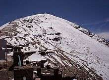
 Chacaltaya peak, October 2012 | |
| Highest point | |
| Elevation | 5,421 m (17,785 ft) |
| Coordinates | 16°21′12″S 68°07′53″W / 16.35333°S 68.13139°WCoordinates: 16°21′12″S 68°07′53″W / 16.35333°S 68.13139°W |
| Geography | |
 Chacaltaya Location of Chacaltaya in Bolivia | |
| Location | La Paz Department, Bolivia |
| Parent range | Cordillera Real, Andes |
| Geology | |
| Mountain type | Fold mountain |
| Climbing | |
| Easiest route | Walk up |
Chacaltaya (Mollo language for "bridge of winds" or "winds meeting point", Aymara for "cold road"[1]) is a mountain in the Cordillera Real, one of the mountain ranges of the Cordillera Oriental, itself a range of the Bolivian Andes. Its elevation is 5,421 meters (17,785 ft). Chacaltaya's glacier — which was as old as 18,000 years — had an area of 0.22 km2 (0.085 sq mi) in 1940, which had been reduced to 0.01 km2 (0.0039 sq mi) in 2007 and was completely gone by 2009.[2][3][4] Half of the meltdown, as measured by volume, took place before 1980.[5] The final meltdown after 1980, due to missing precipitation and the warm phase of El Niño, resulted in the glacier's disappearance in 2009. The glacier was formerly one of the highest in South America, located about 30 kilometers (19 mi) from La Paz, near Huayna Potosí mountain.
Ski area

The glacier on Chacaltaya served as Bolivia's only ski resort. It was the world's highest lift-served ski area and the northernmost in South America as well as the world's second most equatorial after Maoke, Indonesia. The rope tow, the very first in South America, was built in 1939 using an automobile engine; it was notoriously fast and difficult, housed in the site's original clapboard lodge, and is now inoperable. The road to the base of the 200-meter (660 ft) drop is reached by a narrow road, also built in the 1930s. Traditionally, due to the extreme cold weather, the lift operated exclusively on weekends from November to March. Since 2009, skiing is restricted to a 600-foot (180 m) stretch that sometimes receives sufficient snowfall for a run during the winter.[3][6] The mountain is also popular with amateur mountaineers, as the aforementioned road stops only 200 metres (660 ft) from the summit.
Retreat of Chacaltaya glacier
Scientists at the Mount Chacaltaya Laboratory started measuring the Chacaltaya glacier in the 1990s. Predicted at that time to survive until 2015, the Chacaltaya glacier has melted at a much faster rate than expected. The 18,000-year-old glacier has been reduced in recent years to just a few small patches of ice and snow near the top of the mountain.[4]
Many Bolivians on the Altiplano and in two of Bolivia's main cities — La Paz and El Alto — partially depend on the partial melting of Andean glaciers for their water supply during the dry season. The World Bank has warned that many glaciers in the tropical portion of the Andes are expected to disappear within 20 years. This will threaten the water supplies of nearly 80 million people as well as the future generation of hydropower. Bolivia, Ecuador and Peru depend on hydropower for about half their electricity.[4]
Observatory
.JPG)

Located at 5,240 meters (17,190 ft), the Mount Chacaltaya Laboratory began as a weather station in 1942.[7]
It is an important site for gamma ray research [8] since it gained notoriety in the 1940s due to the first observations of pions.
The Chacaltaya Observatory belongs to the Universidad Mayor de San Andrés and it is operated in collaboration with other universities worldwide. It currently hosts the Cosmic Rays research group and since 2011 the Chacaltaya GAW station. The Chacaltaya GAW station is one of the few monitoring sites of essential climate variables (meteorological variables, aerosols and greenhouse gases) in the Southern Hemisphere. It contributes to the Global Atmosphere Watch program.
See also
- List of highest astronomical observatories
- Retreat of glaciers since 1850
- Documentary Samuel in the Clouds
- Chacaltaya GAW station
- Chacaltaya Cosmic Rays observatory
References
- ↑ Enders, John (May 2009). "Bolivia's Chacaltaya glacier is gone". Miami Herald. Retrieved 2015-09-18 – via McClatchy DC.
- ↑ "Vanishing Bolivian Glacier Ends Highest Ski Run (Update1)". Bloomberg. 2009-08-05.
- 1 2 "Farewell to a melting glacier". BBC News. 2007-04-03. Retrieved 2007-07-13.
- 1 2 3 Painter, James (2009-05-12). "Huge Bolivian glacier disappears". BBC New. Retrieved 2015-06-24.
- ↑ Francou, Bernard; Ramirez, Edson; Cáceres, Bolivar; Mendoza, Javier (November 2000). "Glacier Evolution in the Tropical Andes during the Last Decades of the 20th Century: Chacaltaya, Bolivia, and Antizana, Ecuador". AMBIO. 29: 416. ISSN 0044-7447. JSTOR 4315067.
- ↑ Romero, Simon (2007-02-02). "Bolivia's Only Ski Resort Is Facing a Snowless Future". Chacaltaya Journal. The New York Times. Retrieved 2009-05-10.
- ↑ Francesco Zaratti (2009). "The Mount Chacaltaya Laboratory: past, present and future" (PDF). La Paz, Bolivia: Atmospheric Physics Laboratory. Retrieved 2011-04-19.
- ↑ Wamsteker, W; Albrecht, Rudolf; Haubold, Hans J (2004). Developing basic space science world-wide: a decade of UN/ESA workshops. Dordrecht, Boston: Kluwer Academic Publishers. ISBN 978-1-4020-2519-8. OCLC 56105246.
External links
| Wikimedia Commons has media related to Chacaltaya. |
 Chacaltaya travel guide from Wikivoyage
- Chacaltaya Glass Chamber Pyramid of the High Altitude Pathology Institute (Clinica IPPA)
- Apex 3 medical research expedition