Ancoraimes Municipality
| Ancoraimes Janq'u Laymi | |
|---|---|
| Municipality | |
|
Children play outside school in the community of Maquilaya, Ancoraimes Municipality. | |
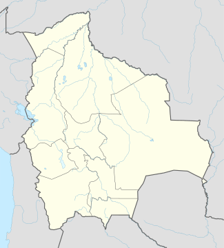 Ancoraimes Location of the Ancoraimes Municipality within Bolivia | |
| Coordinates: 15°50′0″S 68°50′0″W / 15.83333°S 68.83333°WCoordinates: 15°50′0″S 68°50′0″W / 15.83333°S 68.83333°W | |
| Country |
|
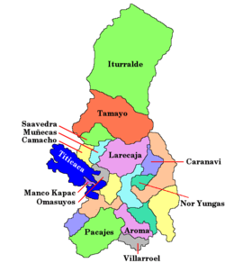
| Department | La Paz Department |
| Province | Omasuyos Province |
| Seat | Ancoraimes |
| Government | |
| • Mayor | Froilan Mamani Mayta (2007) |
| • President | Genaro Quispe Poma (2007) |
| Area | |
| • Total | 125 sq mi (324 km2) |
| Elevation | 12,800 ft (3,900 m) |
| Population (2001) | |
| • Total | 15,199 |
.jpg)
Ancoraimes or Janq'u Laymi (Aymara) is the second municipal section of the Omasuyos Province in the La Paz Department, Bolivia. Its seat is Ancoraimes (Janq'u Laymi).
Geography
Some of the highest mountains of the district are listed below:[1][2][3]
- Chiwanqu
- Ch'amaka Misa
- Ch'umani
- Inkawi
- Jach'a Pata
- Jach'a P'iq'iñ Q'ara
- Jichu Qullu
- Kimsa Chatani
- Muru Qullu
- Paqu Juqhu
- Pinkilluni
- Pukara
- Pukarani
- P'iq'iñ Q'ara
- Qala Qala
- Qutu Uma Qullu
- Q'ara Qullu (Ancoraimes)
- Taypi K'ark'a
- Wila Sirka
- Wisk'achani
References
- ↑ Bolivian IGM map 1:50,000 5846-III Ancoraimes
- ↑ Bolivian IGM map 1:50,000 5846-IV Mina Matilde
- ↑ "Ancoraimes". INE, Bolivia. Retrieved February 10, 2016. labelled (Khara Kella)
External links
This article is issued from Wikipedia - version of the 10/12/2016. The text is available under the Creative Commons Attribution/Share Alike but additional terms may apply for the media files.