Carlyle, Kansas
| Carlyle | |
|---|---|
| Unincorporated community | |
 Map of Allen County (map legend) | |
| Coordinates: 37°59′37″N 95°23′27″W / 37.99361°N 95.39083°W | |
| Country |
|
| State |
|
| County | Allen County |
| Township | Carlyle |
| Settled | 1858 |
| Elevation[1] | 1,001 ft (305 m) |
| Time zone | Central (CST) (UTC-6) |
| • Summer (DST) | CDT (UTC-5) |
| ZIP code[2] | 66749 |
| Area code(s) | 620 |
| FIPS code | 20-10700 [1] |
| GNIS feature ID | 0484351 |
Carlyle is an unincorporated community in the northwestern part of Allen County, located in southeast Kansas, in the central United States. It was first settled in 1858. Although official populations are not compiled for unincorporated places, the population of the surrounding Carlyle Township was 276 in the 2000 census.
History
A great part of the settlement in Allen County during the year 1858 was in what is now Deer Creek Township, along and near Deer Creek. In the fall of 1857, a small colony had been formed in Parke and Johnson counties, Indiana, for the purpose of making a settlement, and building up a town, which was to be named Carlyle. After the selection of the site north of Deer Creek, in 1857, two young men, P.M. Carmine and R.V. Ditmars were left to build cabins. In the spring of 1858, the colonists began to arrive. Among the first were T.P. Killen, J.M. Evans, S.C. Richards, J.W. Scott, David Bergen, and H. Scott. The Carlyle colony selected 320 acres (1.3 km2) for a town site and proposed to build a church, schoolhouse and make other improvements calculated to insure the speedy building up of the proposed town. Finding many difficulties in the way of making a prosperous town, the project was abandoned, and the site cut up into farms, which were soon opened.
Though not successful in building a town, the colony prospered. A post office was secured, and a postal route established from Leavenworth via Hyatt, in Anderson County, Carlyle and Cofachique to Humboldt, in 1858. A church and schoolhouse was afterward built, a high school kept up, and part of the time there has been a store, while it had always retained the post office. Carlyle was well known and it had always been a prosperous and progressive neighborhood. When the Leavenworth, Lawrence and Galveston railroad (later the K.C., L. & S.K. R.R.) was built, Carlyle was made a station.[3]
The post office was finally closed in November 1988.[4]
The railroad tracks in Carlyle have since been converted to a rail trail. The trail is part of the Prairie Spirit Trail State Park.[5]
Geography
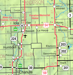
Carlyle is located at 37°59′37″N 95°23′27″W / 37.99361°N 95.39083°W (37.9936436, -95.3908145),[1] in Township 23–24 south, Range 18 east. Contained entirely within Carlyle Township in Allen County, it is about five miles (8 km) north of Iola (the county seat), at the intersection of Texas Road and CR 1600 and less than a mile west of U.S. Route 169. An abandoned railroad passes to the east of Carlyle.[6]
References
- 1 2 3 "US Board on Geographic Names". United States Geological Survey. 2007-10-25. Retrieved 2008-01-31.
- ↑ "ZIP Code Lookup". United States Postal Service. Archived from the original (JavaScript/HTML) on 2007-09-03. Retrieved 2008-01-10.
- ↑ Copied from the following public domain source: Cutler, William G. (1883). "Allen County". History of the State of Kansas. Chicago, IL: A.T. Andreas. Retrieved 2007-11-10..
- ↑ "Kansas Post Offices Database". Kansas State Historical Society. Retrieved 2007-11-11. Containing information taken from Baughman, Robert W. Kansas Post Offices, May 29, 1828–August 3, 1961. Kansas Postal History Society.
- ↑ "Homepage". BikePrairieSpirit.com. Retrieved 17 May 2014.
- ↑ "KDOT County Maps". 1999. Retrieved 2007-11-11.
Municipalities and communities of Allen County, Kansas, United States | ||
|---|---|---|
| Cities | 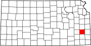 | |
| Unincorporated communities | ||
| Townships | ||
Coordinates: 37°59′37″N 95°23′27″W / 37.99361°N 95.39083°W