Petrolia, Kansas
| Petrolia | |
|---|---|
| Unincorporated community | |
 Map of Allen County (map legend) | |
| Coordinates: 37°44′45″N 95°28′18″W / 37.74583°N 95.47167°W | |
| Country | United States |
| State | Kansas |
| County | Allen |
| Township | Logan |
| Elevation[1] | 951 ft (290 m) |
| Time zone | Central (CST) (UTC-6) |
| • Summer (DST) | CDT (UTC-5) |
| ZIP code | 66720 |
| Area code(s) | 620 |
| FIPS code | 20-55625 [1] |
| GNIS feature ID | 474962 [1] |
Petrolia is an unincorporated community situated along the Neosho River in the southwestern part of Allen County, located in southeast Kansas, in the central United States of America. Although official populations are not compiled for unincorporated places, the population of the surrounding Logan Township was 225 in the 2000 census.
History
In 1910, Petrolia had a money order postoffice, an express office, and was a trading point for the neighborhood. The population that year was 200.[2]
Petrolia had a post office from July 1905 until September 1953.[3]
Geography
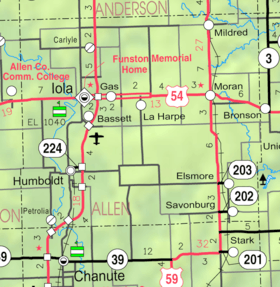
Petrolia is located at 37°44′45″N 95°28′18″W / 37.74583°N 95.47167°W (37.7458767, -95.4716486),[1] in Sections 31–32, Township 26 south, Range 18 east. Less than a mile from the southern border of Allen County, it is situated west of the Neosho River and to the south of Scatter Creek. Contained entirely within Logan Township, it is about 5 miles south-southwest of Humboldt and 13 miles from Iola (the county seat).[4] U.S. Route 169 crosses the Neosho River a mile to the south of Petrolia.
See also
References
- 1 2 3 4 "US Board on Geographic Names". United States Geological Survey. 2007-10-25. Retrieved 2008-01-31.
- ↑ Frank W. Blackmar, ed. (1912). "Petrolia". Kansas: a cyclopedia of state history, embracing events, institutions, industries, counties, cities, towns, prominent persons, etc ... II. Chicago: Standard Pub Co. p. 369. Retrieved 2007-12-15.
- ↑ "Kansas Post Offices Database". Kansas State Historical Society. Retrieved 2007-12-15. Containing information taken from Baughman, Robert W. Kansas Post Offices, May 29, 1828–August 3, 1961. Kansas Postal History Society.
- ↑ "KDOT County Maps". 1999. Retrieved 2007-12-15.
Municipalities and communities of Allen County, Kansas, United States | ||
|---|---|---|
| Cities | 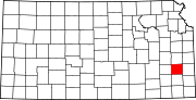 | |
| Unincorporated communities | ||
| Townships | ||
Coordinates: 37°44′45″N 95°28′18″W / 37.74583°N 95.47167°W