Bassett, Kansas
| Bassett, Kansas | |
|---|---|
| City | |
 Location within Allen County and Kansas | |
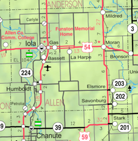 KDOT map of Allen County (legend) | |
| Coordinates: 37°54′14″N 95°24′29″W / 37.90389°N 95.40806°WCoordinates: 37°54′14″N 95°24′29″W / 37.90389°N 95.40806°W | |
| Country | United States |
| State | Kansas |
| County | Allen |
| Township | Iola |
| Government | |
| • Type | Mayor–Council |
| Area[1] | |
| • Total | 0.09 sq mi (0.23 km2) |
| • Land | 0.06 sq mi (0.16 km2) |
| • Water | 0.03 sq mi (0.08 km2) |
| Elevation | 981 ft (299 m) |
| Population (2010)[2] | |
| • Total | 14 |
| • Estimate (2012[3]) | 15 |
| • Density | 160/sq mi (61/km2) |
| Time zone | Central (CST) (UTC-6) |
| • Summer (DST) | CDT (UTC-5) |
| ZIP code | 66749 (Iola) |
| Area code(s) | 620 |
| FIPS code | 20-04450 [4] |
| GNIS feature ID | 0474493 [5] |
Bassett is a city situated along the Neosho River in the west-central part of Allen County, located in southeast Kansas, in the central United States of America. As of the 2010 census, the city population was 14.[6]
History
Bassett was founded in 1903. The following year the Bassett and Concreto extensions were made to the Iola Electric Railroad street car line. In 1914, the first concrete road in Kansas was laid in Bassett.[7]
Geography
Bassett is located at 37°54′14″N 95°24′29″W / 37.90389°N 95.40806°W (37.904017, -95.408005).[8] The city is situated east of the Neosho River along the south bank of Elm Creek in Iola Township, and it lies adjacent to the southern border of the city of Iola (the county seat). Lake Bassola lies to the east of the city. The city is less than two miles southwest of the interchange between U.S. Routes 54 and 169.
According to the United States Census Bureau, the city has a total area of 0.09 square miles (0.23 km2), of which, 0.06 square miles (0.16 km2) is land and 0.03 square miles (0.08 km2) is water.[1]
Climate
The climate in this area is characterized by hot, humid summers and generally mild to cool winters. According to the Köppen Climate Classification system, Bassett has a humid subtropical climate, abbreviated "Cfa" on climate maps.[9]
Demographics
| Historical population | |||
|---|---|---|---|
| Census | Pop. | %± | |
| 1910 | 415 | — | |
| 1920 | 319 | −23.1% | |
| 1930 | 194 | −39.2% | |
| 1940 | 124 | −36.1% | |
| 1950 | 117 | −5.6% | |
| 1960 | 67 | −42.7% | |
| 1970 | 62 | −7.5% | |
| 1980 | 31 | −50.0% | |
| 1990 | 20 | −35.5% | |
| 2000 | 22 | 10.0% | |
| 2010 | 14 | −36.4% | |
| Est. 2015 | 14 | [10] | 0.0% |
| U.S. Decennial Census | |||
2010 census
As of the census[2] of 2010, there were 14 people, 5 households, and 4 families residing in the city. The population density was 233.3 inhabitants per square mile (90.1/km2). There were 10 housing units at an average density of 166.7 per square mile (64.4/km2). The racial makeup of the city was 100.0% White.
There were 5 households of which 40.0% had children under the age of 18 living with them, 80.0% were married couples living together, and 20.0% were non-families. 0.0% of all households were made up of individuals. The average household size was 2.80 and the average family size was 3.00.
The median age in the city was 38 years. 28.6% of residents were under the age of 18; 7.1% were between the ages of 18 and 24; 35.7% were from 25 to 44; 28.5% were from 45 to 64; and 0.0% were 65 years of age or older. The gender makeup of the city was 64.3% male and 35.7% female.
2000 census
As of the U.S. Census in 2000,[4] there were 22 people, 10 households, and 7 families residing in the city. The population density was 309.1 people per square mile (121.3/km²). There were 10 housing units at an average density of 140.5 per square mile (55.2/km²). The racial makeup of the city was 95.45% White and 4.55% Black or African American.
There were 10 households out of which 30.0% had children under the age of 18 living with them, 50.0% were married couples living together, 10.0% had a female householder with no husband present, and 30.0% were non-families. 20.0% of all households were made up of individuals and none had someone living alone who was 65 years of age or older. The average household size was 2.20 and the average family size was 2.14.
In the city the population was spread out with 13.6% under the age of 18, 22.7% from 18 to 24, 22.7% from 25 to 44, 31.8% from 45 to 64, and 9.1% who were 65 years of age or older. The median age was 34 years. For every 100 females there were 120.0 males. For every 100 females age 18 and over, there were 137.5 males.
The median income for a household in the city was $14,688, and the median income for a family was $14,375. Males had a median income of $16,250 versus $0 for females. The per capita income for the city was $12,388. None of the population and none of the families were below the poverty line.
Government
Bassett is incorporated as a city of the third class and, as such, receives services from Iola Township and Allen County.
See also
References
- 1 2 "US Gazetteer files 2010". United States Census Bureau. Archived from the original on 2012-01-24. Retrieved 2012-07-06.
- 1 2 "American FactFinder". United States Census Bureau. Retrieved 2012-07-06.
- ↑ "Population Estimates". United States Census Bureau. Archived from the original on 2013-06-17. Retrieved 2013-05-29.
- 1 2 "American FactFinder". United States Census Bureau. Archived from the original on 2013-09-11. Retrieved 2008-01-31.
- ↑ "US Board on Geographic Names". United States Geological Survey. 2007-10-25. Retrieved 2008-01-31.
- ↑ "2010 City Population and Housing Occupancy Status". U.S. Census Bureau. Archived from the original on July 21, 2011. Retrieved April 6, 2011.
- ↑ Toland, David C. "Time Line of Allen County, Kansas (1803–1992)". Retrieved 2007-12-15.
- ↑ "US Gazetteer files: 2010, 2000, and 1990". United States Census Bureau. 2011-02-12. Retrieved 2011-04-23.
- ↑ Climate Summary for Bassett, Kansas
- ↑ "Annual Estimates of the Resident Population for Incorporated Places: April 1, 2010 to July 1, 2015". Retrieved July 2, 2016.
Further reading
- County
- Atlas and plat book of Allen County, Kansas; Kenyon Company; 90 pages; 1921.
- Plat book of Allen County, Kansas; North West Publishing Co. ; 33 pages; 1906.
External links
| Wikimedia Commons has media related to Bassett, Kansas. |
- City
- Schools
- USD 257, local school district
- Maps
- Bassett City Map, KDOT
Municipalities and communities of Allen County, Kansas, United States | ||
|---|---|---|
| Cities | 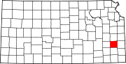 | |
| Unincorporated communities | ||
| Townships | ||