Moran, Kansas
| Moran, Kansas | |
|---|---|
| City | |
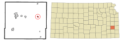 Location within Allen County and Kansas | |
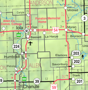 KDOT map of Allen County (legend) | |
| Coordinates: 37°54′58″N 95°10′15″W / 37.91611°N 95.17083°WCoordinates: 37°54′58″N 95°10′15″W / 37.91611°N 95.17083°W | |
| Country | United States |
| State | Kansas |
| County | Allen |
| Government | |
| • Type | Mayor–Council |
| Area[1] | |
| • Total | 0.42 sq mi (1.09 km2) |
| • Land | 0.42 sq mi (1.09 km2) |
| • Water | 0 sq mi (0 km2) |
| Elevation | 1,106 ft (337 m) |
| Population (2010)[2] | |
| • Total | 558 |
| • Estimate (2012[3]) | 550 |
| • Density | 1,300/sq mi (510/km2) |
| Time zone | Central (CST) (UTC-6) |
| • Summer (DST) | CDT (UTC-5) |
| ZIP code | 66755 |
| Area code(s) | 620 |
| FIPS code | 20-48125 [4] |
| GNIS feature ID | 0474519 [5] |
Moran is a city in Allen County, Kansas, United States. As of the 2010 census, the city population was 558.[6]
History
Moran had its start in the year 1881 by the building of the Missouri Pacific Railroad through that territory.[7][8]
Geography
Moran is located at 37°54′58″N 95°10′15″W / 37.91611°N 95.17083°W (37.916168, -95.170718).[9] According to the United States Census Bureau, the city has a total area of 0.42 square miles (1.09 km2), all land.[1]
Climate
The climate in this area is characterized by hot, humid summers and generally mild to cool winters. According to the Köppen Climate Classification system, Moran has a humid subtropical climate, abbreviated "Cfa" on climate maps.[10]
Demographics
| Historical population | |||
|---|---|---|---|
| Census | Pop. | %± | |
| 1890 | 463 | — | |
| 1900 | 464 | 0.2% | |
| 1910 | 559 | 20.5% | |
| 1920 | 676 | 20.9% | |
| 1930 | 651 | −3.7% | |
| 1940 | 592 | −9.1% | |
| 1950 | 616 | 4.1% | |
| 1960 | 549 | −10.9% | |
| 1970 | 550 | 0.2% | |
| 1980 | 643 | 16.9% | |
| 1990 | 551 | −14.3% | |
| 2000 | 562 | 2.0% | |
| 2010 | 558 | −0.7% | |
| Est. 2015 | 520 | [11] | −6.8% |
| U.S. Decennial Census | |||
2010 census
As of the census[2] of 2010, there were 558 people, 219 households, and 142 families residing in the city. The population density was 1,328.6 inhabitants per square mile (513.0/km2). There were 247 housing units at an average density of 588.1 per square mile (227.1/km2). The racial makeup of the city was 93.7% White, 2.0% African American, 1.3% Native American, 0.2% Pacific Islander, 0.2% from other races, and 2.7% from two or more races. Hispanic or Latino of any race were 1.1% of the population.
There were 219 households of which 34.2% had children under the age of 18 living with them, 43.4% were married couples living together, 10.5% had a female householder with no husband present, 11.0% had a male householder with no wife present, and 35.2% were non-families. 28.8% of all households were made up of individuals and 14.6% had someone living alone who was 65 years of age or older. The average household size was 2.36 and the average family size was 2.75.
The median age in the city was 45.4 years. 23.7% of residents were under the age of 18; 7.1% were between the ages of 18 and 24; 18.5% were from 25 to 44; 28.9% were from 45 to 64; and 21.9% were 65 years of age or older. The gender makeup of the city was 45.7% male and 54.3% female.
2000 census
As of the census[4] of 2000, there were 562 people, 224 households, and 140 families residing in the city. The population density was 1,351.3 people per square mile (516.6/km²). There were 255 housing units at an average density of 613.1 per square mile (234.4/km²). The racial makeup of the city was 96.44% White, 0.36% African American, 1.96% Native American, and 1.25% from two or more races. Hispanic or Latino of any race were 0.36% of the population.
There were 224 households out of which 28.6% had children under the age of 18 living with them, 48.7% were married couples living together, 9.4% had a female householder with no husband present, and 37.5% were non-families. 31.3% of all households were made up of individuals and 19.6% had someone living alone who was 65 years of age or older. The average household size was 2.34 and the average family size was 2.99.
In the city the population was spread out with 24.7% under the age of 18, 7.7% from 18 to 24, 21.9% from 25 to 44, 20.5% from 45 to 64, and 25.3% who were 65 years of age or older. The median age was 42 years. For every 100 females there were 90.5 males. For every 100 females age 18 and over, there were 80.8 males.
The median income for a household in the city was $30,179, and the median income for a family was $37,750. Males had a median income of $25,729 versus $19,028 for females. The per capita income for the city was $14,080. About 8.7% of families and 13.1% of the population were below the poverty line, including 6.7% of those under age 18 and 25.3% of those age 65 or over.
Notable people
- Debra Dene Barnes, 1968 Miss America[12]
See also
References
- 1 2 "US Gazetteer files 2010". United States Census Bureau. Retrieved 2012-07-06.
- 1 2 "American FactFinder". United States Census Bureau. Retrieved 2012-07-06.
- ↑ "Population Estimates". United States Census Bureau. Retrieved 2013-05-29.
- 1 2 "American FactFinder". United States Census Bureau. Retrieved 2008-01-31.
- ↑ "US Board on Geographic Names". United States Geological Survey. 2007-10-25. Retrieved 2008-01-31.
- ↑ "2010 City Population and Housing Occupancy Status". U.S. Census Bureau. Retrieved April 6, 2011.
- ↑ Blackmar, Frank Wilson (1912). Kansas: A Cyclopedia of State History, Volume 2. Standard Publishing Company. p. 311.
- ↑ "Moran". Allen County. Retrieved 18 May 2014.
- ↑ "US Gazetteer files: 2010, 2000, and 1990". United States Census Bureau. 2011-02-12. Retrieved 2011-04-23.
- ↑ Climate Summary for Moran, Kansas
- ↑ "Annual Estimates of the Resident Population for Incorporated Places: April 1, 2010 to July 1, 2015". Retrieved July 2, 2016.
- ↑ Associated Press (1967-09-10). "Kansas Beauty is Miss America". Tuscaloosa News. p. 1.
Further reading
- County
- Atlas and plat book of Allen County, Kansas; Kenyon Company; 90 pages; 1921.
- Plat book of Allen County, Kansas; North West Publishing Co. ; 33 pages; 1906.
External links
| Wikimedia Commons has media related to Moran, Kansas. |
- City
- Schools
- USD 256, local school district
- Maps
- Moran City Map, KDOT
Municipalities and communities of Allen County, Kansas, United States | ||
|---|---|---|
| Cities | 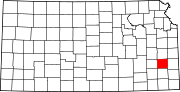 | |
| Unincorporated communities | ||
| Townships | ||