Marmaton Township, Allen County, Kansas
| Marmaton Township | |
|---|---|
| Township | |
 Location in Allen County | |
| Coordinates: 37°54′25″N 095°09′36″W / 37.90694°N 95.16000°WCoordinates: 37°54′25″N 095°09′36″W / 37.90694°N 95.16000°W | |
| Country | United States |
| State | Kansas |
| County | Allen |
| Area | |
| • Total | 55.8 sq mi (144.6 km2) |
| • Land | 55.6 sq mi (143.9 km2) |
| • Water | 0.3 sq mi (0.7 km2) 0.5% |
| Elevation | 1,099 ft (335 m) |
| Population (2010) | |
| • Total | 877 |
| • Density | 16/sq mi (6.1/km2) |
| GNIS feature ID | 0474522 |
Marmaton Township is one of twelve townships in Allen County, Kansas, United States. As of the 2010 census, its population was 877.[1] The majority of inhabitants are farmers.
Geography
Marmaton Township covers an area of 55.8 square miles (144.6 km2) and contains one incorporated settlement, Moran. According to the USGS, it contains one cemetery, Moran.
The stream of Sweet Branch runs through this township.
References
- ↑ "Geographic Identifiers: 2010 Demographic Profile Data (G001): Marmaton township, Allen County, Kansas". U.S. Census Bureau, American Factfinder. Retrieved May 10, 2013.
External links
Municipalities and communities of Allen County, Kansas, United States | ||
|---|---|---|
| Cities | 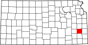 | |
| Unincorporated communities | ||
| Townships | ||
This article is issued from Wikipedia - version of the 11/11/2013. The text is available under the Creative Commons Attribution/Share Alike but additional terms may apply for the media files.