Cape Cod Rail Trail
| Cape Cod Rail Trail | |
|---|---|
|
The trail in Harwich, Massachusetts | |
| Established | 1970s [1] |
| Length | 22 mi (35 km) |
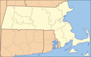
| Location | Barnstable County |
| Trailheads |
Route 134, South Dennis Lecount Hollow Road, Wellfleet Willow Street, Yarmouth (in planning) |
| Use | Hiking, bicycling, horseback riding, roller blading, and cross country skiing |
| Hiking details | |
| Trail difficulty | Easy |
| Season | Year-round |
| Hazards | Deer ticks, poison ivy, road crossings |
| Surface | Paved surface |
| Right of way | Former railroad line |
| Website | Cape Cod Rail Trail |
| Trail map | |
|
| |

The Cape Cod Rail Trail (CCRT) is a 22-mile (35 km) paved rail trail located on Cape Cod in Massachusetts.[2] The trail route passes through the towns of Dennis, Harwich, Brewster, Orleans, Eastham, and Wellfleet. It connects to the 6-plus mile (10 km) Old Colony Rail Trail leading to Chatham, and 8 miles (13 km) of trails within Nickerson State Park.[3] It also passes near the end of the Nauset Bike Trail leading to Coast Guard Beach in Cape Cod National Seashore.[4] Short side trips on roads lead to several other national seashore beaches.
History
The original rail line was constructed by the Old Colony Railroad, which was later incorporated into the New York, New Haven & Hartford Railroad. The New Haven Railroad merged into Penn Central in 1968: it went bankrupt by 1970. The corridor was purchased by the Commonwealth of Massachusetts (Massachusetts Department of Transportation (MassDOT)) in 1976, and a portion of the right-of-way was converted to the Cape Cod Rail Trail by the Massachusetts Department of Conservation and Recreation in the 1970s.[1] MassDOT leases the line from Route 134 in South Dennis to LeCount Hollow Road in South Wellfleet to the Massachusetts Department of Conservation and Recreation for trail use.[5]
Route description
South Dennis trailhead to Nickerson State Park
The trail begins in South Dennis at an intersection with Massachusetts Route 134. This trailhead has a parking area and is just south of exit 9A on US 6. The first 1.5 miles of the trail run through a primarily industrial area in Dennis. It roughly parallels Great Western Road during this section, crossing it twice.
The trail then enters Harwich as the landscape turns to houses and agricultural land before turning gradually north and intersecting with the Old Colony Rail Trail at a bike rotary between miles 3 and 4. The rotary has maps and benches in its center for users of the trail. North of the rotary, the trail passes through a wooded area and crosses Route 6 via an overpass. Another parking area is located at the trail's intersection with Headwaters Drive, north of Route 6. It crosses Massachusetts Route 124 at mile 5 and runs along it until mile 7, passing several ponds and entering Brewster at mile 6.
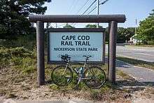
The CCRT crosses Massachusetts Route 137 at mile 8 and then runs south of central Brewster. A parking area is located at Route 137, before the trail enters Nickerson State Park just past mile 10. It is in the park for about two-thirds of a mile, intersecting some of its trails, then crosses Massachusetts Route 6A by an underpass as it leaves the park. A parking lot is located near the Route 6A crossing.
Nickerson State Park to Wellfleet trailhead

The trail continues to cross Namskaket Creek into Orleans between miles 11 and 12. The crossing of Route 6 between miles 12 and 13, near exit 12 on the highway, constitutes the trail's only (and brief) on-road section. The trail follows Salty Ridge Road to West Road, where it turns right over the Route 6 overpass. It then turns left and leaves West Road heading northeast into downtown Orleans. The CCRT crosses Main Street just past mile 13; this area in downtown has several bike shops and dining establishments. A parking area is located off of Old Colony Way, named for the former railroad that the trail runs on. The landscape changes to a less dense residential area as it leaves downtown. The third crossing of Route 6 is an overpass just before mile 14 and just east of the Orleans rotary.
The trail enters Eastham shortly after this, at which point there is a large salt marsh, Boat Meadow Creek, on the west side of the trail. It was at this location that a rudimentary canal, Jeremiah's Gutter, had existed in the 1700s, allowing passage from Cape Cod Bay to the Cove area of Orleans. Around mile marker 15, the trail enters the residential section of Eastham, crossing Gov. Prence Road. The trail remains relatively straight through most of Eastham, and at-grade road crossings are fairly frequent. Locust Road, between miles 16 and 17, is a signed bike route to the Nauset Bicycle Trail (which brings cyclists and pedestrians to Coast Guard Beach) and the Salt Pond Visitor Center, as well as other points in the Cape Cod National Seashore. In the North Eastham area, just west of the trail's intersection with Brackett Road, there are bike shops as well as delis and a Ben and Jerry's ice cream shop. North of Brackett Road, the trail runs closer to Route 6 and several motels and restaurants on the east side of the highway are connected directly to the trail.
The CCRT enters Wellfleet near mile 19. Sparse residential development lies west of the trail, while the east side of the trail is fronted by a power line right-of-way, with undeveloped National Seashore land beyond that. North of mile 21, the trail intersects Marconi Beach Road, which leads to Marconi Beach and the Marconi Station site. Sparse development continues, with the trail ending near mile 22, at Lecount Hollow Road in Wellfleet. This trailhead has the only parking area on the trail north of Orleans. The road provides access to several Wellfleet town beaches.
Expansion and development
Plans call for a 3.7 mile extension of the rail trail westward from the current South Dennis trailhead to Peter Homer Park on Old Town House Road in South Yarmouth, which is the east limit of freight track used by the Massachusetts Coastal Railroad. The extension project calls for the creation of a 10-foot-wide paved path, construction of a 160-foot pedestrian bridge over Bass River and the construction of a new 97-space parking lot to be built off Station Avenue in South Yarmouth (the former site of the New Haven's Bass River station). Work on the extension is scheduled to be completed in 2016 or 2017.[6]
Efforts to extend the bike path from the Wellfleet trailhead north to Provincetown have been under discussion for many years. Four possible routes were identified in 2011: a scenic corridor through the National Seashore, a share-the-road corridor of back roads west of Route 6, a corridor that follows the former railroad right of way (some of which is now privately owned), and a route that would take the bike path north along a power line right of way from South Wellfleet into Truro and then along Route 6 into Provincetown.[7]
Crossings
All crossings in Barnstable County, Massachusetts.
| Town | Crossing | Notes |
|---|---|---|
| Wellfeelt | Lecount Hollow Rd. | Northern
Terminus |
| Cemetery Rd. | ||
| Macaroni Beach Rd. | ||
| Eastham | Nauset Rd. | |
| Brackett Rd. | ||
| Old Orchard Rd. | ||
| underpass | ||
| Kingsbury Beach Rd. | ||
| Locust Rd. | ||
| Samoset Rd. | ||
| Crosby Village Rd. | ||
| Bridge Rd. | ||
| Governor Prence Rd. | ||
| Orleans | Rock Harbor Rd. | overpass |
| freeway
overpass | ||
| Canal Rd. | ||
| Jones Rd. | ||
| Locust Rd. | ||
| Main St. | ||
| West. Rd. | overlap | |
| freeway
overpass | ||
| Salty Ridge Rd. | overlap | |
| Seaview Rd. | ||
| Brewster | Mitchell Ln. | |
| underpass | ||
| Ober Rd. | ||
| Millstone Rd. | ||
| Villages Dr. | underpass | |
| Thad Ellis Rd. | ||
| Underpass Rd. | not a
underpass | |
| School Dr. | ||
| Fishermen's Landing Rd. | ||
| Brewster/ | (twice in a
row) | |
| Harwich | Sequattom Rd. | |
| Headwaters Dr. | ||
| freeway
overpass | ||
| Queen Anne Rd. | ||
| Main St. | underpass | |
| Lothrop Ave. | ||
| Great Western Rd. | ||
| Bells Neck Rd. | ||
| Depot St. | ||
| Dennis | Great Western Rd. | |
| So. Gages Way | ||
| Southern
Terminus |
See also
- Old Colony Rail Trail - between Harwich and Chatham
- Shining Sea Bikeway - between North Falmouth and Woods Hole
References
- 1 2 Cape Cod Commission (August 2011, revised May 20, 2013). "Cape Cod Regional Transportation Plan" (PDF). pp. 165–166, 350. Retrieved September 15, 2014. Check date values in:
|date=(help) - ↑ "Cape Cod Rail Trail". MassParks. Executive Office of Energy and Environmental Affairs. Retrieved February 2, 2014.
- ↑ Johnstone, Stuart (2006). Bike Paths of Massachusetts. Carlisle, Mass.: Active Publications. ISBN 0962799076.
- ↑ "Cape Cod: Bike trails, safety tips, and guidelines" (PDF). National Park Service. Retrieved February 2, 2014.
- ↑ "Official Map" (PDF). MassParks: Cape Cod Rail Trail. Executive Office of Energy and Environmental Affairs. Retrieved February 2, 2014.
- ↑ Legere, Christine (July 8, 2014). "Cape rail trail extension gets put on track". Cape Cod Times. Archived from the original on July 14, 2014. Retrieved July 11, 2014.
- ↑ Bragg, Mary Ann (2011-09-05). "Officials peddling rail trail extension". Cape Cod Times. Retrieved 2014-09-16.
External links
| Wikimedia Commons has media related to Cape Cod Rail Trail. |
- Cape Cod Rail Trail - Massachusetts Department of Conservation and Recreation
- Official Map of the Cape Cod Rail Trail
- Cape Cod Rail Trail - CapeCodBikeGuide.com
- Master planning for bicycle and pedestrian infrastructure on the Outer Cape - Cape Cod Commission
| |||||||||||||||||||||||||
| |||||||||||||||||||||||||
| |||||||||||||||||||||||||
| |||||||||||||||||||||||||
| |||||||||||||||||||||||||
| |||||||||||||||||||||||||
| |||||||||||||||||||||||||