Neponset River
| Neponset River | |
| River | |
| Source | Neponset Reservoir |
|---|---|
| - location | Foxborough, Massachusetts, United States |
| - coordinates | 42°05′10″N 71°14′38″W / 42.086°N 71.244°W |
| Mouth | Dorchester Bay |
| - coordinates | 42°18′00″N 71°02′31″W / 42.300°N 71.042°WCoordinates: 42°18′00″N 71°02′31″W / 42.300°N 71.042°W |
| Length | 29 mi (47 km) |
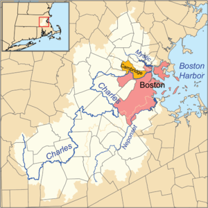 Charles, Mystic and Neponset river watersheds | |
The Neponset River is a river in eastern Massachusetts in the United States. Its headwaters are at the Neponset Reservoir in Foxborough, near Gillette Stadium. From there, the Neponset meanders generally northeast for about 29 miles (47 km) to its mouth at Dorchester Bay between Quincy and the Dorchester section of Boston, near the painted gas tank.[1]
The Neponset River forms the southern boundary of the city of Boston, passing through the neighborhoods of Readville, Hyde Park, Mattapan and Dorchester, and forming with the northern border of the city of Quincy. In addition, the Neponset touches the towns of Foxborough, Walpole, Sharon, Norwood, Canton, Westwood, Dedham, and Milton.
The Neponset River is fed by a drainage basin of approximately 130 square miles, a watershed that includes numerous aquifers, wetlands, streams and surrounding upland areas.[1] Some 250,000 people live in the Neponset River watershed, which in addition to the towns listed above, includes portions of Stoughton, Medfield, Dover, and Randolph.
The Canton River, a tributary of the Neponset River, is located in Canton, Massachusetts. It flows under the Canton Viaduct.
History
Before Europeans arrived, the area was inhabited by Algonquian-speaking Native American tribes. The Wamsutta site (19-NF-70) is a paleoindian site, which was dated to 10210 ± 60 BP).[2] Evidence of habitation along the Neponset River also includes the Middle Archaic (ca. 5000 BC) at sites such as Green Hill near the Blue Hills.[3]
The river's recorded history begins in 1619 when Native Americans traveled down the Neponset River to Thompson's Island, where they traded furs with English settlers. [4]
The falling waters of the Neponset provided the energy for the country's first water-powered grist mill, gunpowder mill, paper mill and the Revere Copper Company, among others.[1]
The upper stretch of the Neponset River, in Foxborough, Walpole and Norwood, is steeply sloped, dropping about 228 feet (69 m) over its first 12 miles, (19 km) and so the earliest years of the Industrial Revolution brought the Neponset to prominence. In 1635, Israel Stoughton built the first dam on the Neponset (only the second dam in the entire New World) for his grist mill. It was the first of three mills for flour, gunpowder and paper making. In 1640, shipbuilding began at Gulliver's Creek Wharf, and in 1673 John Trescott built a lumber mill on the river.
In 1765, a chocolate mill was established by Dr. James Baker and Irish immigrant John Hannon (later known as Walter Baker & Company producing Baker's Chocolate) in the Lower Mills section of Dorchester, and in 1770 Daniel Vose's Wholesale Shipping Warehouses at the second Milton Town Landing at Lower Mills were at the peak of their operation. Ship building and commercial shipping were the major river industries at the estuary. In 1773, George Clark built a paper mill on remnants of Trescott's Lumber Mill, which became the Tileston and Hollingsworth Paper Mill in 1836. In 1826, the river became the terminus of the Granite Railway, the first commercial railway in the United States. This river was central to the establishment of the town of Walpole.
Neponset River Reservation
Today the Neponset River and its watershed are increasingly being protected and opened up as a recreational destination for the benefit of local residents. Several recommendations of the 1966 Lower Neponset River Reservation Master Plan have been implemented, including the reclamation of the former Hallet Street landfill and the old Neponset Drive-In to provide the 66-acre (270,000 m2) Pope John Paul II Park, which opened to the public in 2001. At Squantum Point in Quincy, phase one of Squantum Point Park, 25 acres (100,000 m2) of a 50-acre (200,000 m2) former U.S. Navy Airfield, was developed as waterfront parkland with assistance from National Grid plc and dedicated in the spring of 2001.
2.4 miles (3.9 km) of the Lower Neponset River Trail opened in 2003.[5] The trail follows the former right-of-way of the Dorchester and Milton Branch Railroad, the western part of which is also used by the MBTA Ashmont–Mattapan High Speed Line.
References
- 1 2 3 Neponset River Watershed Association, Watershed, retrieved 2009-10-17
- ↑ Jim Chandler On the Shore of a Pleistocene Lake: The Wamsutta Site (19-NF-70) M.A.S. In: Bulletin of the Massachusetts Archaeological Society 62 (2001) 52-62. It is a.ka. Neponset/Wamsutta site.
- ↑ Hoffman, Curtis (2006). "Late to Transitional Archaic Exchange in Eastern Massachusetts". Archaeology of Eastern North America. 34: 93–94. JSTOR 40914499.
- ↑ MassBike, Neponset River: A History, retrieved 2009-10-17
- ↑ "Neponset River Reservation". MassParks. Executive Office of Energy and Environmental Affairs, Department of Conservation and Recreation. Retrieved August 17, 2013.
External links
River and watershed
- Neponset River - MWRA Massachusetts Government Web site
- Neponset River Watershed Association
- Neponset watershed map
- River Bank Destruction, Squantum Point , Neponset River
Greenway and recreation
- Neponset River Greenway official site
- Neponset Greenway Corridor Completion Project - includes plans, maps
- Neponset River Reservation Department of Conservation and Recreation
- Massbike listing for Neponset River Greenway
| |||||||||||||||||||||||||
| |||||||||||||||||||||||||
| |||||||||||||||||||||||||
| |||||||||||||||||||||||||
| |||||||||||||||||||||||||
| |||||||||||||||||||||||||
| |||||||||||||||||||||||||