Lower Neponset River Trail
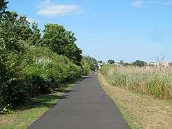
The Lower Neponset River Trail is a 2.4-mile-long (3.9 km) rail trail running along the Neponset River in the Dorchester section of Boston, Massachusetts.[1][2] It roughly follows the path of the eastern part of the Dorchester and Milton Branch Railroad from the Port Norfolk neighborhood in Dorchester to the Central Avenue T Station in Milton,[3] passing through Pope John Paul II Park, the Neponset Marshes, and the Lower Mills area.[1]
References
External links
|
|---|
|
|
|
|
|
|
|
| Wildlife Management Areas |
|---|
| Wildlife
Management Areas | |
|---|
| Wildlife
Sanctuaries |
- Billingsgate Island
- Carr Island
- E. Howe Forbush
- Egg Rock
- Grace A. Robson
- J.C. Phillips
- Knight
- Penikese Island
- Ram Island (Salisbury)
- Ram Island (Mattapoisett)
- Susan B. Minns
- Tarpaulin Cove
- Watatic Mountain
|
|---|
|
|
|
| |
|---|
|
- Black Pond Bog
- Boat Meadow
- Francis Newhall Woods
- Grassy Pond
- Greene Swamp
- Halfway Pond Island
- Hawley Bog
- Hockomock Swamp
- Hoft Farm
- Homer-Watcha Preserve
- Katama Plains
- McElwain-Olsen
- Miacomet Moors
- Reed Brook
- Drury
- Sandy Neck
- David H. Smith Preserve and Fire Trail
- Stacy Mountain
- Tatkon
|
|
|
|
|
|
|
|
|
|