Barney Circle
| Barney Circle | |
|---|---|
| Neighborhood | |
|
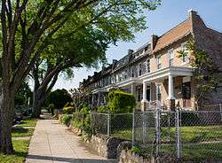
800 block of Kentucky Avenue SE in the Barney Circle neighborhood | |
 Map of Washington, D.C., with the Barney Circle neighborhood highlighted in red | |
| Coordinates: 38°52′42.6″N 076°58′50.5194″W / 38.878500°N 76.980699833°W | |
| Country | United States |
| Territory | Washington, D.C. |
| Constructed | c. 1917 |
| Named for | Commodore Joshua Barney |
Barney Circle is a small residential neighborhood located on the west bank of the Anacostia River in southeast Washington, D.C., in the United States. The neighborhood's name refers to the traffic circle which exists at Pennsylvania Avenue SE just before it crosses the John Philip Sousa Bridge over the Anacostia. The Barney Circle traffic circle is named for Commodore Joshua Barney, commander of the Chesapeake Bay Flotilla in the War of 1812.
Neighborhood
The Barney Circle neighborhood covers the area bounded by Pennsylvania Avenue SE, Potomac Avenue SE, 15th Street SE, and 17th Street SE. However, many of the residents of the surrounding areas (such as the Lincoln Park and Capitol Hill East neighborhoods) consider themselves to live in Barney Circle. The neighborhood's disputed boundaries may stretch as far north as East Capitol Street, as far south as the Southeast/Southwest Freeway, and as far east as D.C. Jail at 19th and D Streets SE.[1]
A small portion of Barney Circle—bounded by E, D, 17th, and 18th Streets NE—was occupied by Eastern Methodist Cemetery from 1824 to 1892.[2][3] Most of Barney Circle remained undeveloped until World War I, when homes were built in the area to provide low-cost housing for war workers. Most of the structures in the neighborhood are two-story, single-family brick rowhouses. Earlier developments on Capitol Hill featured homes which were narrow and deep, while the homes in the Barney Circle neighborhood are wide and shallow.[4] These type of homes, an innovation in the first decade of the 20th century, are known as "daylight rowhouses" because each room was lit as much as possible by sunlight coming through windows.[5] The homes in the Barney Circle neighborhood generally are set back from the street at a uniform distance, and have a small front yard and an open-air porch. As with most rowhouses, the homes typically have mansard roofs with dormers which provide third-floor sleeping, working, or storage space.[4]
Although little of the architecture in the area is outstanding, the neighborhood has retained its historic appearance. Few homeowners have installed modern siding or altered their structure in an ahistoric manner.[4]
Traffic circle
Barney Circle was part of the original L'Enfant Plan for the District of Columbia. However, it was designated a square, not a traffic circle, on the city's original plats.[6] For reasons which are not clear, it was constructed as a traffic circle instead, with the name "Pennsylvania Avenue Circle".[7] On August 19, 1911, President William Howard Taft signed S. 306 into law (Public Law No. 33), formally changing the name of the circle to "Commodore Barney Circle"[8] in honor of Commodore Joshua Barney.[7]
In 1940, the construction of the John Philip Sousa Bridge connected Barney Circle with Pennsylvania Avenue SE on the east side of the Anacostia River. A streetcar turnaround and bus lane was carved from the center of the circle,[6] and a $7,000 bus and streetcar terminal occupied the western portion of the site. The terminal opened on January 26, 1941.[9]
The Inner Loop's effect on Barney Circle

In 1956, federal and regional transportation planners proposed an Inner Loop Expressway composed of three circumferential beltways for the District of Columbia. The innermost beltway would have formed a flattened oval about a mile in radius centered on the White House. The middle beltway would have formed an arc along the northern portion of the city, running from the proposed Barney Circle Freeway (whose terminus would have been near Robert F. Kennedy Memorial Stadium) through Anacostia Park, cutting northwest through the Trinidad neighborhood along Mt. Olivet Road NE, following the Amtrak rail line north to Missouri Avenue NW, along Missouri Avenue NW to Military Road NW, along Military Road NW across Rock Creek Park to Nebraska Avenue NW, down Nebraska Avenue NW to New Mexico Avenue NW, and down New Mexico Avenue NW and across Glover-Archbold Park until it terminated near 37th Street NW at the north end of Georgetown. Two decades of protest led to the cancellation of all but the Interstate 395 and Interstate 695 portions of the plan. The unbuilt portions of the project were finally cancelled in 1977.[10][11][12]
The failure to complete the Inner Loop left the Sousa Bridge's approaches incomplete and confusing. The bus and streetcar terminal were removed, and Pennsylvania Avenue SE now ran directly through the center of the circle. M Street was disconnected from the circle, and now dead-ended in a roundabout a block east of 12th Street SE. Unmarked Interstate 695 delivered three lanes of traffic to a one-lane on-ramp to the bridge, and traffic backed up for miles every day as a traffic light allowed only a few cars onto the bridge's southbound lanes during rush hour. Four lanes of traffic (two northbound, two southbound) passed beneath the bridge's terminus, dead-ending at a non-existent Inner Loop and connected haphazardly to the northeastern side of the circle. An off-ramp delivered most northbound bridge traffic around the incomplete Barney Circle and under the bridge onto Interstate 695 westbound. A dangerous right-hand turn with no deceleration ramp left local traffic coming to a swift halt to access 17th Street SE — but not Kentucky Avenue SE, which now had to be accessed from local streets. K Street SE now curved north and east around the west side of Barney Circle, and traffic lights on the street caused even more backups both on K Street and on the Sousa Bridge.[6]
Barney Circle Freeway fight
In 1975, federal, regional, and city transportation planners proposed an extension to I-695/Southeast Freeway to be called the "Barney Circle Freeway" to help alleviate the problems created by the failure to complete the Inner Loop.[13] The freeway would extend I-695 past its existing terminus at Barney Circle and travel along the western bank of the Anacostia River (through Anacostia Park) to East Capitol Street and Robert F. Kennedy Memorial Stadium.[13][14][15] A new bridge over the Anacostia River at Burnham Barrier would provide vehicles easy access to the Anacostia Freeway.[13][14][15] The Barney Circle Freeway would have delinked Barney Circle from I-695, and reconstructed the on- and off-ramps to Sousa Bridge so that the bridge returned to its traditional function as a local bridge rather than a route for commuters to access the Anacostia Freeway and points east in the state of Maryland. The combined bridge and freeway project was ready for construction to begin in 1981,[15] and its cost was estimated to be $93.5 million.[14] But after protests from residents of Capitol Hill (who feared the Barney Circle Freeway would cause more traffic to flow into the area) as well as environmentalists, the District of Columbia agreed to reduce the number of lanes on the Barney Circle Freeway to two from four.[16]
The protests and legal and regulatory challenges to the proposed freeway did not end, however, and by 1992 the freeway's cost had ballooned to $160 million and it remained unbuilt.[17] By 1993, although costs for the project had increased to $200 million, D.C. Mayor Sharon Pratt Kelly gave her approval for construction to begin.[18] But construction was delayed yet again when the Sierra Club Legal Defense Fund, Anacostia Watershed Society, Committee of 100 on the Federal City, Citizens Committee to Stop It Again, D.C. Federation of Civic Associations, Friends of the Earth, Kingman Park Civic Association, the Barney Circle Neighborhood Watch, Urban Protectors, and American Rivers sued to force the city to scale back the freeway even further, add exit ramps at the junction of Pennsylvania Avenue SE and I-695, and alter traffic patterns (e.g., creating more one-way streets) on Capitol Hill.[19][20][21] Federal Highway Administration (FHWA) officials agreed in August 1994 to conduct an additional environmental impact assessment regarding the project,[22] but later said the assessment's findings did not alter its earlier conclusion that construction of the roadway and bridge project was economically feasible, technologically appropriate, and environmentally sound.[13][23] However, the D.C. City Council had the final say on whether to proceed with the project or not. In December 1994, the City Council bowed to neighborhood opposition and voted overwhelmingly to reject the project.[24]
Restructuring of Barney Circle


Since the cancellation of the Inner Loop Expressway, motorists wanting to access the Baltimore–Washington Parkway or U.S. Route 50 in Maryland (the John Hanson Highway) would often travel Interstate 695 to Barney Circle, wait at the traffic light there, cross the Sousa Bridge, wait at a traffic light on the southwestern terminus of the bridge, and make a left turn against oncoming traffic to access a narrow and dangerous ramp that led to northbound D.C. Route 295 (the Anacostia Freeway). The combination of traffic lights, left turn, and mixing of both through-traffic and local traffic created extensive traffic congestion on the Sousa Bridge during evening rush hour.[25][26][27][28][29]
In 2009, the District of Columbia Department of Transportation (DDOT) began the replacement of the 11th Street Bridges. It closed the westbound segment of Interstate 695 from the 11th Street Bridges to Barney Circle in late November 2012,[30] and the eastbound lanes in early 2013.[29] This portion of was Interstate 695 was subsequently decommissioned, turning roughly five blocks of six-lane highway into city streets from the National Highway System.[31] The unfinished "mixing bowl" exchange on the southern terminus of the 11th Street Bridges was also altered. Local traffic was separated from through-traffic by the construction of a bridge dedicated for local traffic only, and ramps connecting the bridge to D.C. Route 295 were created. Construction of the new ramps began in May 2012,[27] with the ramp from southbound D.C. Route 295 onto the 11th Street Bridge completed in July 2012.[28] The ramp from the bridges to northbound D.C. Route 295 opened on December 19, 2012.[32]
These changes removed a significant portion of the traffic using Sousa Bridge, from 50,000 vehicles per day (each way) in 2004 to an estimated 35,000 vehicles per day (each way) in 2030.[33] DDOT also redesigned and rebuilt the ramp from Pennsylvania Avenue SE to northbound D.C. Route 295 to improve its safety.[25][34]
Decommissioned Interstate 695 began to be transformed into a boulevard named "Southeast Boulevard".[28] The reconstruction project, estimated to take 18 to 24 months, raised the roadway 20 feet (6.1 m) to bring it level with the grad of the surrounding streets.[29] The six-lane former highway began to be turned into a four-lane grand boulevard with a landscaped median and pedestrian nature trail. Southeast Boulevard was designed to link Barney Circle to 11th Street SE.[28]
In 2013, DDOT published plans to reconfigure Barney Circle. Priorities for the project included improving and restoring access to neighborhood streets, and adding pedestrian and bicycle connectivity to local streets and the Anacostia River waterfront. DDOT also began exploring whether to connect Southeast Boulevard to 12th, 13th, 14th, and 15th Streets SE.[35] By 2014, DDOT's plan involved possible reconstructing of Barney Circle into an intermodal transportation hub as well. DDOT planners said that construction on this project might begin as early as 2016.[36]
References
- ↑ Henderson, Nell (November 21, 1992). "Barney Circle: Fostering a Sense of Community". The Washington Post. Retrieved May 6, 2014.
- ↑ Proctor, Black & Williams 1930, p. 538.
- ↑ "Back From the Tomb". The Washington Post. November 4, 1892. p. 8.
- 1 2 3 "Barney Circle Neighborhood: 2009 Most Endangered Places". D.C. Preservation League. 2009. Retrieved May 6, 2014.
- ↑ Hayward & Belfoure 1999, p. 128.
- 1 2 3 Eisen, Jack (June 19, 1971). "Barney Circle Gone, But Will Return". The Washington Post.
- 1 2 Memorial to Congress of the Columbia Historical Society 1911, p. 183.
- ↑ Corps of Engineers 1911, p. 3160.
- ↑ "Bus Terminal to Be Opened This Morning at Barney Circle". The Washington Post. January 26, 1941.
- ↑ Levey, Bob; Levey, Jane Freundel (November 26, 2000). "End of The Roads". The Washington Post; Eisen, Jack (July 13, 1973). "Md. Vetoes I-95 Extension Into District". The Washington Post; Feaver, Douglas B. (May 13, 1977). "Three Sisters Highway Project Is Killed - Again". The Washington Post.
- ↑ Schrag 2004, pp. 648-673.
- ↑ Mohl 2008, pp. 193-226.
- 1 2 3 4 Wheeler, Linda (August 21, 1995). "D.C. Freeway in Limbo". The Washington Post.
- 1 2 3 Lynton, Stephen J. (September 26, 1983). "D.C. Plans to Link Two City Freeways". The Washington Post.
- 1 2 3 Lippman, Thomas W. (January 5, 1981). "D.C. Is Planning $850 Million For Maintenance, New Projects". The Washington Post.
- ↑ Lynton, Stephen J. (July 7, 1985). "D.C. Reviving Long-Controversial Anacostia Road Plan". The Washington Post.
- ↑ Spencer, Duncan (June 18, 1992). "Hill Faces Another Classic Battle Over a Freeway". Roll Call.
- ↑ Castaneda, Ruben (September 17, 1993). "Construction to Begin in '94 On Anacostia-SE Freeway Link". Washington Post.
- ↑ Spencer, Duncan (February 3, 1994). "Road Project Hits Legal Dead End". Roll Call.
- ↑ Cohn, D'Vera (May 13, 1994). "Suit Seeks to Stop D.C. Plans to Build Connector Highway". The Washington Post.
- ↑ Neufeld, Matt (May 13, 1994). "People Sue to Stop SE Freeway Proposal". The Washington Times.
- ↑ Neufeld, Matt (August 18, 1994). "Barney Circle Plan Up in Air". The Washington Times.
- ↑ "Freeway Given Boost". The Washington Post. April 19, 1996.
- ↑ Loeb, Vernon (March 5, 1997). "Norton Declares Barney Circle Freeway a Dead End". The Washington Post.
- 1 2 Thomson, Robert (December 18, 2012). "D.C. Preparing to Open New Highway Link". The Washington Post. Retrieved May 5, 2014.
- ↑ Thomson, Robert (August 18, 2011). "At Four-Way Stops, A Risky Maximization of Opportunity". The Washington Post.
- 1 2 Thomson, Robert (May 27, 2012). "Piece By Piece at 11th Street Bridge". The Washington Post.
- 1 2 3 4 Thomson, Robert (August 16, 2012). "Freeway Fragment to Undergo An Identity Swap". The Washington Post.
- 1 2 3 Thomson, Robert (October 7, 2012). "Bridge Ramps Remake D.C. Freeways". The Washington Post.
- ↑ Freeman, Amy (November 27, 2012). "Sousa Bridge Access to Freeway/395 to Close Thursday". WTOP.com. Retrieved May 5, 2014.
- ↑ DeBonis, Mike (November 28, 2011). "Interstate 695 Reappears in D.C.". The Washington Post.
- ↑ Thomson, Robert (December 30, 2012). "With A New Freeway Link, Is It Time to Reconsider How the Roads Are Marked?". The Washington Post.
- ↑ Grahame, Tom (July–August 2005). "Myriad Traffic Studies Reflect Pace of Change to Come" (PDF). Capital Hill Restoration Society Newsletter. p. 1.
- ↑ Thomson, Robert (July 8, 2012). "D.C. Freeway Ramps, Beltway Paving, Rush Plus Tweaks". The Washington Post.
- ↑ District of Columbia Department of Transportation 2013, p. 2.
- ↑ District of Columbia Department of Transportation 2014, p. 10.
Bibliography
| Wikimedia Commons has media related to Barney Circle. |
- Corps of Engineers (1911). Annual Reports, War Department, Fiscal Year Ended June 30, 1911. Report of the Chief of Engineers, U.S. Army, 1911. Part III. Washington, D.C.: Department of the Army.
- District of Columbia Department of Transportation (November 21, 2013). Barney Circle and Southeast Boulevard Transportation Planning Study (PDF) (Report). Washington, D.C.: D.C. Department of Transportation. Retrieved April 26, 2014.
- District of Columbia Department of Transportation (March 6, 2014). Projects Update Meeting For Ward 7 (PDF) (Report). Washington, D.C.: D.C. Department of Transportation. Retrieved April 26, 2014.
- Hayward, Mary Ellen; Belfoure, Charles (1999). The Baltimore Rowhouse. New York: Princeton Architectural Press. ISBN 9781568981772.
- "Memorial to Congress of the Columbia Historical Society". Records of the Columbia Historical Society, Washington, D.C. 1911.
- Mohl, Raymond A. (2008). "The Interstates and the Cities: The U.S. Department of Transportation and the Freeway Revolt, 1966-1973". Journal of Policy History: 193–226.
- Proctor, John Claggett; Black, Frank P.; Williams, E. Melvin (1930). Washington, Past and Present: A History. New York: Lewis Historical Publishing Co.
- Schrag, Zachary M. (July 2004). "The Freeway Fight in Washington, D.C.: The Three Sisters Bridge in Three Administrations". Journal of Urban History: 648–673.
 |
Kingman Park | | ||
| Capitol Hill | |
Congressional Cemetery | ||
| ||||
| | ||||
| Anacostia River |