Woodridge, Washington, D.C.
| Woodridge | |
|---|---|
| Neighborhood of Washington, D.C. | |
|
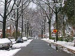
Woodridge is a primarily residential neighborhood. | |
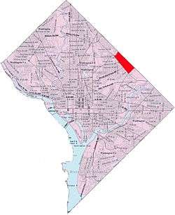 Woodridge within the District of Columbia | |
| Coordinates: 38°55′53″N 76°58′16″W / 38.9315°N 76.9711°WCoordinates: 38°55′53″N 76°58′16″W / 38.9315°N 76.9711°W | |
| Country | United States |
| District | Washington, D.C. |
| Ward | Ward 5 |
| Government | |
| • Councilmember | Kenyan McDuffie |
Woodridge is a residential neighborhood located on the northeastern edge of Washington, D.C., bounded by Eastern Avenue on the east, Michigan Avenue to the north, South Dakota then 18th St. to the west, and Bladensburg Road to the south. Its central commercial strips are Rhode Island Avenue NE and Bladensburg Road NE. It is located roughly between the neighborhoods of Brookland in D.C. to the northwest, Brentwood to the west and the city of Mount Rainier, Maryland to the east.
Education
District of Columbia Public Schools operates public schools.
District of Columbia Public Library operates the Woodridge Neighborhood Library located at 18th and Rhode Island Ave. N.E.[1]
Real Estate

Real estate research blog Redfin named Woodridge the hottest DC neighborhood of 2015.[2] In the first half of 2015, median home prices in Woodridge rose 20 percent.[3]
Bladensburg Road is a main stretch of road in Woodrige. Walmart is planning on opening one of four locations in the area. [4]
References
| Wikimedia Commons has media related to Woodridge, Washington, D.C.. |
- ↑ "Hours & Locations." District of Columbia Public Library. Retrieved on October 21, 2009.
- ↑ https://www.redfin.com/research/reports/special-reports/2015/hottest-neighborhoods-of-2015.html#washington-dc. Missing or empty
|title=(help) - ↑ http://dc.urbanturf.com/articles/blog/home_price_watch_woodridge_market_on_the_rise/10229. Missing or empty
|title=(help) - ↑ "Bladensburg Road"