Grant Circle
| Grant Circle | |
|---|---|
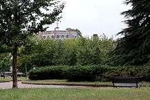 Grant Circle, with Petworth United Methodist Church in the background, in September 2016. | |
| Location | |
| Washington, DC | |
| Roads at junction: |
New Hampshire Avenue NW Illinois Avenue NW Varnum Street NW 5th Street NW |
| Construction | |
| Type: | Traffic circle |
| Maintained by: | DDOT |
Grant Circle is a traffic circle located in the Petworth neighborhood of Northwest Washington, D.C. New Hampshire and Illinois Avenues NW, Varnum Street NW, and 5th Street NW all intersect at this circle. The park within the circle is owned and administered by the National Park Service through its Rock Creek Park unit.[1] The circle and the buildings flanking it were listed on the National Register of Historic Places in 2015.
History
Originally named Sheridan Circle, it was renamed Grant Circle in 1889.[2] Grant Circle is named for Ulysses S. Grant, the former Union Army General who won the American Civil War and later was twice elected President of the United States. The local newsletter, the Grant Circular, is named after the circle. The blocks surrounding the circle were fully developed by 1920,[3] and the 40-foot (12 m) roadway around it paved in 1921.[4]
The park within the circle is owned and administered by the National Park Service through its Rock Creek Park unit.[5] [6]
Petworth Methodist Church was built on Grant Circle in 1920.[3][7] Grant Circle was one of the first locales in the city where the double-globe "Bacon lamppost" was erected. The Beaux-Arts-style street light was approved by the United States Commission of Fine Arts in 1924, and is still used only in the city's historic core.[8]
See also
References
- ↑ "Reservation List: The Parks of the National Park System, Washington, DC" (PDF). www.nps.gov. National Park Service; Land Resources Program Center; National Capital Region. Retrieved 1 May 2016.
- ↑ "District Government: Changes in Petworth". Washington Evening Star. January 21, 1889. p. 3.
- 1 2 Committee on Appropriations 1920, p. 543.
- ↑ District of Columbia Appropriations 1921, p. 3.
- ↑ "Reservation List: The Parks of the National Park System, Washington, DC" (PDF). www.nps.gov. National Park Service; Land Resources Program Center; National Capital Region. Retrieved 1 August 2014.
- ↑ Urban Mass Transportation Administration 1991, p. 5-26.
- ↑ Urban Mass Transportation Administration 1991, p. R-86.
- ↑ Commission of Fine Arts 1926, p. 120-121.
Bibliography
- Commission of Fine Arts (1926). Tenth Report of the Commission of Fine Arts. July 1, 1921 to December 31, 1925. Washington, D.C.: Government Printing Office.
- Committee on Appropriations (1920). District of Columbia Appropriation Bill, 1922. Washington, D.C.: Government Printing Office.
- "District of Columbia Appropriations. S.Rept. 391. 66th Cong. 3d sess.". Senate Documents. December 6, 1920 to March 4, 1921. Vol. 16. 66th Cong. 3d sess. Washington, D.C.: Government Printing Office. 1921.
- Urban Mass Transportation Administration (1991). Washington Regional Rapid Transit System (Metrorail), Green Line (E Route) Mid-city Segment: Environmental Impact Statement. Washington, D.C.: U.S. Government Printing Office.
External links
Coordinates: 38°56′35″N 77°01′09″W / 38.9431°N 77.0192°W