Swampoodle, Washington, D.C.

Swampoodle was an Irish neighborhood in Washington, D.C. A geographic approximation of its borders would be K Street to the north, G Street to the south, 1st Street NW to the west, and 2nd Street NE to the east. Through the center of it ran the principal branch of Tiber Creek. The name Swampoodle is attributed to a newspaper reporter covering the ground-breaking of St. Aloysius Church in 1857, who referred to the land at the site on North Capitol and I street as containing numerous swamps and puddles that often occurred when Tiber Creek overflowed its banks.
Early history
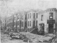
Swampoodle developed during the second half of the 19th century, providing a place of refuge for emigrants following the Irish potato famine. It gained a reputation for being a lawless shantytown, where crime, prostitution and drunkenness were rife. At the core of the district was Jackson Alley, considered a virtual no-go area for the police. The area was known for overcrowding and outbreaks of malaria, typhoid and dysentery. But Swampoodle was a thriving community, whose Irish construction workers helped build Washington, D.C. As Swampoodle was then on the edge of the city, many of the residents kept goats and cows, sometimes in livestock pens among the alleys dividing their modest houses. This continued up to the early 20th century.
There is a play by Tom Swift about life in Swampoodle by the same name. It was produced by Solas nua with support from the Ireland-based Performance Corporation to help combat stereotypes about the Irish. It consists of colorful, disparate stories about life in the predominantly Irish neighborhood.[1]
Impact of Union Station construction
The demise of Swampoodle as a community began with the construction of Union Station in 1907. The plan involved the demolition of the core of Swampoodle, around Jackson’s Alley.[2] As part of the plan, the remainder of Tiber Creek was filled in. Over 300 houses were demolished to make way for the station and the rail yard. This physically divided the neighborhood and led to many of the 1,600 former residents moving to other parts of the city. Rezoning led to increased heavy industry in the area, making it unattractive for residential use.
The Irish identity of Swampoodle died away; by the post-World War II period, even the name Swampoodle was largely forgotten.
In 1941, Uline Arena, later renamed Washington Coliseum was built in the area. The arena was a venue for many concerts, including The Beatles' first show in America, which took place in 1964.[3] The arena was the home of the Basketball Association of America's Washington Capitols, coached by Red Auerbach, the American Basketball Association's Washington Caps, and other college and pro teams.
Relevance to baseball
Swampoodle was home of the Swampoodle Grounds, which was the home of the Washington Nationals baseball club from 1886 to 1889.
Present
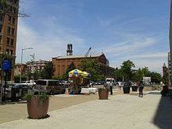
Today the area is occupied primarily by office complexes, rail yards serving Union Station, and Gonzaga College High School, a legacy of its original settlers. It is surrounded by some of the original dwellings, particularly in the Near Northeast section to the east of Delaware Avenue. The neighborhood got some press after a play about it debuted in 2011.[4][5] Since 2007, the neighborhood has been included in the rebranded "NoMa" which stands for "North of Massachusetts Avenue."[6] It is served by the NoMa – Gallaudet University Metro station and Union Station.
The Capitol Hill Restoration Society (CHRS) has begun walking tours[7][8] of four square blocks of the neighborhood that remains today between F and H Streets NE and 2nd and 4th Streets NE. CHRS is proposing to expand the Capitol Hill Historic District[9] to include these blocks as part of their Beyond the Boundaries initiative.[10]
See also
References
- ↑ Wallace, Arminta (3 June 2011). "If we can make it there..". Irish Times. p. 12.
- ↑ Map of Swampoodle and Proposed Union Depot | Ghosts of DC
- ↑ Marc Fisher (2006-11-27). "Saved: D.C.'s Beatles Connection". Washington Post.
- ↑ DCist review
- ↑ Swampoodle: The neighborhood behind the play | TBD.com
- ↑ NoMa | NoMa Business Improvement District, Washington, DC
- ↑ Capitol Hill Restoration Society » Walking Tour of Swampoodle June 29, 2013
- ↑ http://chrs.org/wp-content/uploads/2013/06/WTswampoodleHandout1307BP.pdf
- ↑ Restoration Society Hears Recommendations for Major Expansion of Capitol Hill Historic District | CAPITOL HILL CORNER
- ↑ Capitol Hill Restoration Society » Beyond the Boundaries Map
Coordinates: 38°54′0.7″N 77°0′29.5″W / 38.900194°N 77.008194°W