Bloomingdale (Washington, D.C.)
| Bloomingdale, Washington, D.C. | |
|---|---|
| Neighborhood of Washington, D.C. | |
|
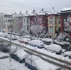
Victorian-style rowhouses in Bloomingdale. | |
 Bloomingdale within the District of Columbia | |
| Country | United States |
| District | Washington, D.C. |
| Ward | Ward 5 |
| Advisory Neighborhood Commission | ANC 5E |
| Government | |
| • Councilmember | Kenyan McDuffie (Ward 5) |
| Area | |
| • Total | .20 sq mi (0.5 km2) |
| Population (2010) | |
| • Total | 4,980 |
| • Density | 24,510.0/sq mi (9,463.4/km2) |
| ZIP Code | 20001 |
| Area code(s) | 202 |
| Website | http://bloomingdaleneighborhood.blogspot.com/ |
Bloomingdale is a neighborhood in the Northwest quadrant of Washington, D.C., less than two miles (3 km) north of the United States Capitol building. It is a primarily residential neighborhood, with a small commercial center near the intersection of Rhode Island Avenue and First Street, NW featuring bars, restaurants, and food markets.
Most of Bloomingdale's houses are Victorian-style rowhouses built around 1900 as single-family homes. Today, these houses remain primarily single-family residences, with some recently converted to two-unit condominiums.
Geography
Bloomingdale is bounded to the north by Channing St., N.W., to the east by North Capitol St., to the south by Florida Ave., N.W., and to the west by Second St., N.W.. The neighborhoods bordering Bloomingdale are LeDroit Park to the west, Shaw to the southwest, Truxton Circle to the south, Eckington to the east, and Stronghold to the northeast. To the north, sit the McMillan Sand Filtration Site and the McMillan Reservoir.
The neighborhood is a low-lying area, located at the foot of hills that extend to the north and east. Its topography is also shaped by the now-buried Tiber Creek, one branch of which generally followed what is now Flagler Place NW.
Because of its low-lying topography, flooding had periodically occurred in parts of the neighborhood during particularly strong rainstorms. Most recently, in July 2012, the stormwater drainage system was overwhelmed three times by particularly strong storms, flooding vehicles near the topographic basin at T Street NW and Rhode Island Avenue NW and causing sewer backflow to enter some basements, many of which were rental apartments.[1] Since then, DC Water has undertaken a large-scale tunneling project designed to divert and contain stormwater.[2]
Government
Bloomingdale is in the southwestern part of Ward 5, currently represented on the City Council by Councilmember Kenyan McDuffie. Bloomingdale is also a part of Advisory Neighborhood Commission 5E, currently represented by Commissioners Teri Janine Quinn, Bertha Holliday, Horacio Sierra, and Dianne Barnes.[3]
History
The present-day neighborhood of Bloomingdale originated from several large estates. Located just outside the original boundary of the City of Washington as designed by Pierre L’Enfant in 1792, and in the former County of Washington, the neighborhood known today as Bloomingdale began to develop its residential character in the late 1880s, shortly after the County of Washington was absorbed by the City of Washington, and just over a century after L'Enfant's plan was developed.
(1792-1870s) Farms and Estates
The lands that comprise Bloomingdale first began as large estates and orchards. Boundary Street, today Florida Avenue, was the dividing line between paved, planned streets (to the south of Boundary), laid out in the original city L'Enfant plan, and rural country (to the north of Boundary), where a variety of landowners maintained orchards, large country estates, and later, a mixture of commercial properties.
In 1823, George Beale and his wife Emily Truxton Beale bought a 10-acre (40,000 m2) parcel of land north of the Capitol, along the City boundary, for $600.00 from Wm Bradley.[4] This estate, which they named the "Bloomingdale Estate," grew to 50 acres (200,000 m2).
As late as the 1870s, the land where Bloomingdale now sits was largely a collection of undeveloped private estates and farming properties, most prominently those of the Beales and of the Moores.[5]
(1880s onward) Residential Development
Following Emily Truxton Beale's death in 1885,[6] her heirs began to sell large tracts of the estate to developers. The old Bloomingdale estate rapidly changed into the modern neighborhood configuration as developers and land speculators transformed the undeveloped lands for denser residential development, located between the already established residential LeDroit Park and Eckington neighborhoods. By 1887, city planners had proposed extending the city's paved street grid into Bloomingdale.[7]

In 1891, the 45-acre (180,000 m2) Moore farm, located north and west of the former Beale estate and representing some of the last undeveloped property in the area, was also sold to private developers.[8] It was incorporated into the already-underway Bloomingdale neighborhood.
By 1892, the reconfiguration of Bloomingdale was underway, as large estates had been consolidated and reconfigured into the predecessor to the modern neighborhood,[9] with further development of the neighborhood by 1894.[10] During this time, roads corresponding to the grid system of Washington's streets were improved, curbed, and paved. Streams and creeks were buried or re-directed, most notably the Tiber Creek, much of which had already been buried south of Bloomingdale in the original City of Washington. One section of the Tiber Creek in Bloomingdale ran along what is now Flagler Place.[11]
Construction on some of the earliest homes was completed between 1892 and 1900. And, in the early 1900s, the remainder of the surrounding blocks had been built in a speculative nature by such developers as Harry Wardman, Francis Blundon, and S. H. Meyers within the following decade. The neighborhood website contains a list of Bloomingdale's Wardman built homes. Many of Wardman's first homes incorporate elements of Richardson Romanesque architecture (a sub-category of Victorian).[12] This can be seen in the ornate floral and vine-like stone carving around doors and windows of many Bloomingdale homes. His later homes, like those on Adams and Bryant Streets, are in an architectural style for which he is most prominently known, brick homes which incorporate a deeper setback from the street and large covered front porch. Blundon built several homes along 1st Street including 100 W Street, NW, which he occupied with his family.
Development continued, and in 1904, the neighborhood's first school, the Nathaniel Parker Gage School, was built on the 2000 block of 2nd Street. (The school has now been converted to private condominiums.) By 1909, the old estates had been sold and divided, the Tiber Creek had been buried, and the neighborhood street layout had been fully developed into its present form.[13][14]
Many homes in the northern section of Bloomingdale still retain carriage houses in the block interiors. Some have been converted to private residences.
Present
Like many D.C. neighborhoods since the early 2000s, Bloomingdale has undergone substantial gentrification, with the neighborhood's once-numerous vacant properties being repurposed, sharp rises in property values, and rapidly shifting demographics. The population is primarily African American, which has maintained deep roots in the community for many years. There is also a growing Hispanic and White population. According to the 2010 census, the diverse population of Bloomingdale was 59% African American and 30% White with the last 11% split between Hispanic residents, Asian residents, and residents of other origins.[15]
During this period of rapid change, numerous new businesses have opened in the neighborhood, primarily restaurants, bars, and food markets. These include Windows Market, Big Bear Cafe, Yoga District, El Camino, Bacio Pizzeria, FieldToCity, Rustik Tavern, Boundary Stone, Aroi Thai Sushi Bar, Grassroots Gourmet, Red Hen, Showtime Lounge, and Crisp Kitchen & Bar. Every summer, the Bloomingdale Farmers' Market operates on Sundays on R St between Florida Ave and 1st Street, N.W.
On May 22, 2010, the city officially dedicated a new street, Bloomingdale Court, N.W., on the alleyway between the 100 block of U and V Streets, N.W., and the 2000 block of 1st Street and Flagler Place, N.W.
The neighborhood has several active neighborhood groups and associations including the Bloomingdale Civic Association.
Crispus Attucks Park
.jpg)
Bloomingdale has its own community-managed and community-owned greenspace, Crispus Attucks Park. The acre-and-a-quarter park, located within the court bounded by First, U, V, and North Capitol Streets N.W., was previously the site of a telephone switching station and cable yard for the Chesapeake & Potomac Telephone Company. In the late 1960s, the building and the site were left vacant until 1977, when a neighborhood organization that ultimately became the Crispus Attucks Development Corporation convinced Chesapeake & Potomac to sell the property.[16]
The park is named after Crispus Attucks, an African American who was killed in the Boston Massacre and is often regarded as the first person killed in the American Revolution. Crispus Attucks Park is privately owned, but open to the public, and is maintained through charitable donations and volunteer labor coordinated by the Crispus Attucks Development Corporation.
Notable residents and historic landmarks
- Samuel Gompers, the founder of the American Federation of Labor in 1886 (which later became the AFL-CIO), owned and lived in the house at 2122 1st Street, N.W. following its construction in 1900. The house was declared an individual landmark on the National Register of Historic Places in 1974.
- Chita Rivera, an accomplished and singer, dancer, and entertainer on Broadway. Ms. Rivera lived with her parents (both federal government employees) on the 2100 block of Flagler Place, N.W. until the age of 15.
- The Barnett-Aden Gallery, formerly at 127 Randolph Place, N.W.,[17] was the first privately owned black gallery in the US and one of Washington, D.C.’s principal art galleries when it opened in 1943. Founded by James V. Herring and Alonzo J. Aden, it was named ‘Barnett-Aden' to honor Aden’s mother’s family. While the owners of the gallery were African American, Barnett-Aden was not conceived as a “black gallery.” It was one of the few art places in the city in which artists representing different nationalities, races, and ethnicities were exhibited together.[18] The gallery's collection has since been sold and relocated.
- The house at 116 Bryant Street, N.W. was the subject of the Supreme Court case, Hurd v. Hodge, 334 U.S. 24 (1948).[19] The house was purchased by James M. Hodge and his wife, an African American couple, in violation of a racially restrictive covenant, which the Hodges challenged in court. This case was a companion to Shelley v. Kraemer, which found the enforcement of racial and religious covenants restricting the sale of certain homes to racial and religion minorities to be unconstitutional. Hurd v. Hodge clarified that this ruling applied to the District of Columbia.[20]
- The Nathaniel Parker Gage School on Second Street, N.W. was built as a school in 1904.[21] It is an historic structure, listed on the National Register of Historic Places in 2008. The building now houses condominiums.
In popular culture
- Though the series is filmed in Baltimore, the opening credit sequence of House of Cards features several prominent shots of the Bloomingdale neighborhood along North Capitol Street, between R Street and T Street.[22]
References
- ↑ "Councilmember: Relief fund needed for victims of Sunday's flooding". wtop.com. Retrieved 2012-09-03.
- ↑ "Bloomingdale and LeDroit Park: The Northeast Boundary Protection Program". dcwater.org. Retrieved 2014-02-21.
- ↑ "Advisory Neighborhood Commission 5E". dc.gov. Retrieved 2014-07-01.
- ↑ "Why Is It Named Bloomingdale?". Ghosts of DC. Retrieved 2014-02-25.
- ↑ "Atlas of fifteen miles around Washington (1879)". Library of Congress. Retrieved 4 May 2016.
- ↑ "Emily Truxton Beale (1798 - 1885) - Find A Grave Memorial". findagrave.com. Retrieved 4 June 2015.
- ↑ "Map of Washington, D.C., and environs : with marginal numbers and measuring tape attachment for instantly locating points of interest within a radius of twenty miles from the Capitol / - Library of Congress". loc.gov. Retrieved 4 June 2015.
- ↑ "Blogger". bloomingdalehistoryproject.blogspot.com. Retrieved 4 June 2015.
- ↑ "The altograph of Washington City, or, stranger's guide : - Library of Congress". loc.gov. Retrieved 4 June 2015.
- ↑ "The vicinity of Washington, D.C. - Library of Congress". loc.gov. Retrieved 4 June 2015.
- ↑ "Hidden Washington: Tiber Creek". Park View, D.C. Retrieved 4 June 2015.
- ↑ Scott, Pamela. "Residential Architecture of Washington, D.C., and Its Suburbs". loc.gov. Library of Congress. Retrieved August 17, 2016.
Last revised: 2005
- ↑ "1907 Baist Map of LeDroit Park and Bloomingdale". Library of Congress. Retrieved 4 May 2016.
- ↑ "Blogger". bloomingdalehistoryproject.blogspot.com. Retrieved 4 June 2015.
- ↑ Annie Gowen (24 March 2011). "In D.C.'s Bloomingdale neighborhood, population changes welcomed and resented". Washington Post. Retrieved 4 June 2015.
- ↑ "crispusattuckspark.org". crispusattuckspark.org. Retrieved 4 June 2015.
- ↑ "Art Exhibition Features Negro". New York Amsterdam News. October 21, 1944. p. 4B.
- ↑ "BARNETT ADEN GALLERY, AFRICAN AMERICAN HERITAGE TRAIL". Cultural Tourism DC. Retrieved 2014-02-26.
- ↑ "Restrictive Writ Cases Argued Before U. S. Supreme Court: Seven Hours Allotted For Argumentation". Atlanta Daily World. January 15, 1948. p. 1.
- ↑ FindLaw | Cases and Codes
- ↑ "Dedication of Gage School: Board of Education Completes Arrangements for Ceremony February 15". The Washington Post. February 9, 1905. p. 5.
- ↑ Sean Hennessey. "bloomingdale". bloomingdaleneighborhood.blogspot.com. Retrieved 4 June 2015.
External links
- The Bloomingdale History Project
- Bloomingdale Neighborhood Blog and Listserv
- Why Is It Named Bloomingdale? - Ghosts of DC local history blog
- If Walls Could Talk: Big Bear Cafe - history of the building which houses Big Bear Cafe
 |
Pleasant Plains | McMillan Sand Filtration Site | Stronghold | |
| LeDroit Park | |
Eckington | ||
| ||||
| | ||||
| Shaw | Truxton Circle |
Coordinates: 38°54′59″N 77°00′41″W / 38.9164°N 77.0114°W